Potential For Record Warmth This Week
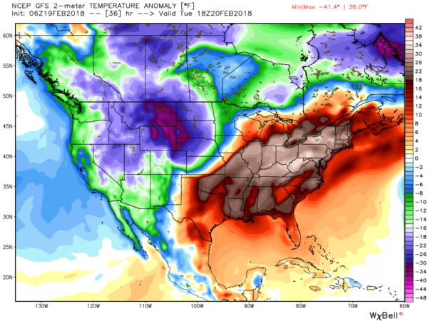
HOLY HIGH AMPLITUDE: A very high amplitude upper air pattern is setting up over the continental U.S. this week… a very cold upper trough will be over the western states, but we will be influenced by a strong upper high over the east. This will set up blowtorch warmth over the eastern and southern states this week, with potential for record warmth.
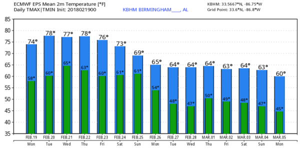
Here are the record daily highs for Birmingham this week…
Today (Feb 19) 76 (1986)
Tomorrow (Feb 20) 78 (1986)
Wednesday (Feb 21) 78 (1922)
Thursday (Feb 22) 81 (1897)
Friday (Feb 23) 83 (1996)
FYI the warmest temperature on record at Birmingham for the month of February is 83, set on Feb 8, 1918… Feb 13, 1962… and Feb 23, 1996.
TODAY/TOMORROW: We are projecting a high between 77 and 80 today, and very close to 80 tomorrow. Clouds and fog this morning will give way to a partly sunny afternoon, and any showers will be few and far between. Pretty much the same situation tomorrow; a mix of sun and clouds with only isolated showers.
WEDNESDAY THROUGH FRIDAY: An approaching front will bring a chance of showers and thunderstorms by Wednesday afternoon and Wednesday night… but no risk of severe storms despite the warmth. Showers and storms remain possible Thursday as the front stalls out near the Tennessee border. That front will then move northward Thursday night, and Friday looks warm with only isolated showers. Highs will remain well up in the 70s, and we could touch 80 in spots on each of the three days as the warm late winter pattern continues.
THE ALABAMA WEEKEND: Another warm day is ahead on Saturday; the high will be close to 80 with a mix of sun and clouds. Showers should be pretty widely separated. Then, the chance of rain will rise Sunday with another front; this one will have little more southward push, and highs should drop back into the 60s with occasional showers and possibly a thunderstorm.
NEXT WEEK AND BEYOND: Looks like we will see highs mostly in the 60s next week, back to seasonal averages. Still no sign of any freezing temperatures for the next 10 days, but global model output suggests potential for cold shots in March, which of course brings up the idea of strong to severe storms at times. That, of course, is to be expected since March does kick off the spring tornado season in Alabama. See the Weather Xtreme video for maps, graphics, and more details.
WEATHER ON THIS DATE IN 1884: In short, severe thunderstorms spawned sixty tornadoes in the southeastern U.S., killing more than 420 persons and causing three million dollars damage. Dubbed “The Enigma Outbreak,” it is thought to be among the largest and most widespread tornado outbreaks in American history, striking on February 19–20, 1884. As the precise number of tornadoes as well as fatalities incurred during the outbreak are unknown, the nickname “Enigma outbreak” has come to be associated with the storm. Nonetheless, an inspection of newspaper reports and governmental studies published in the aftermath reveals tornadoes (or more likely — long-track tornado families) striking Alabama, Georgia, Illinois, Indiana, Kentucky, Mississippi, North Carolina, South Carolina, Tennessee and Virginia. The majority of reported tornado activity was seen across Alabama, Georgia, South Carolina and North Carolina, which were all struck severely by multiple waves of tornado families. In the Southeast, the outbreak began during the late morning in Mississippi, preceded by severe thunderstorms in Louisiana. Shortly thereafter, the outbreak widened and intensified, progressing from Alabama to Virginia between noon and midnight.
BEACH FORECAST: Click here to see the AlabamaWx Beach Forecast Center page.
WEATHER BRAINS: Don’t forget you can listen to our weekly 90 minute netcast anytime on the web, or on iTunes. This is the show all about weather featuring many familiar voices, including our meteorologists here at ABC 33/40. We will produce this week’s show tonight at 8:30 CT… you can watch it live here.
CONNECT: You can find me on all of the major social networks…
Facebook
Twitter
Google Plus
Instagram
Pinterest
Snapchat: spannwx
Look for the next Weather Xtreme video here by 4:00 this afternoon… enjoy the day!
Category: Alabama's Weather, ALL POSTS, Weather Xtreme Videos
About the Author (Author Profile)
James Spann is one of the most recognized and trusted television meteorologists in the industry. He holds the AMS CCM designation and television seals from the AMS and NWA. He is a past winner of the Broadcast Meteorologist of the Year from both professional organizations.Subscribe
If you enjoyed this article, subscribe to receive more just like it.


