More Record Warmth Through Saturday
A NATION DIVIDED: A very high amplitude upper air pattern continues over North America, with a deep upper trough over the western half of the continental U.S… and a strong upper ridge over the East Coast. It is cold and icy over the western two-thirds of the nation, but blowtorch warmth continues across the Deep South and the eastern states…
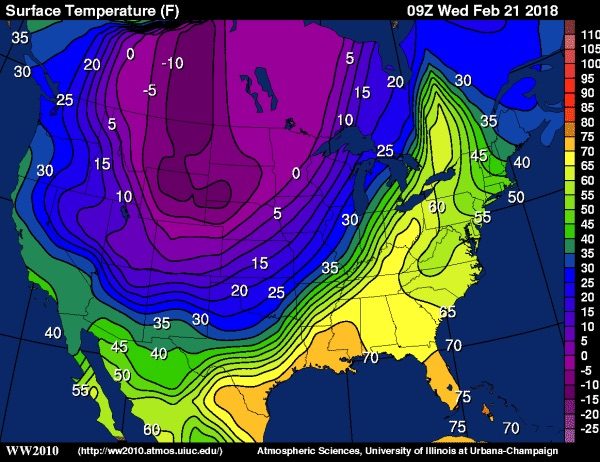
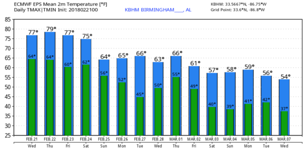
ALABAMA THROUGH SATURDAY: The upper ridge will be the main player in our state, meaning potential for more record warmth on a daily basis through Saturday. Each day we will have a mix of sun and clouds with afternoon highs very close to 80 degrees. This is twenty degrees above the average high of 60 for late February, and in record territory.
In terms of rain chances, we will mention some risk of isolated showers through tomorrow, but the really organized rain will remain to the west along the sharp cold front over East Texas, Louisiana, Arkansas, and far West Tennessee. Friday looks dry for most of Alabama as the ridge strengthens, and showers during the day Saturday should be widely spaced.
COLD FRONT ARRIVES EARLY SUNDAY: A band of organized showers and thunderstorms will push through the state late Saturday night and Sunday morning as the cold front to the west gets a southward nudge. SPC has a risk of severe storms defined for the northwest corner of the state late Saturday night, but the overall threat looks low for the rest of Alabama due to the lack of instability and the main dynamic support passing to the north.
For now, it looks like the main window for rain and storms over the weekend will come from about 12:00 midnight Saturday night through 12:00 noon Sunday. Rain amounts of 1/2 to 3/4″ are likely, so no flooding issues. Sunday will be cooler with a high in the 60s.
NEXT WEEK: The front will stall over South Alabama Sunday night, and as a wave of low pressure moves along the front Monday look fairly wet with periods of rain. The high Monday will b close to 60; some North Alabama communities will hold in the 50s all day. The GFS model continues to advertise drier air on Tuesday, but there will be some risk of showers each day Wednesday through Friday as moist air returns. Highs through the week will be generally in the 60s.
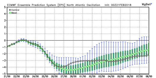
MARCH: With the Arctic Oscillation and the North Atlantic Oscillation going negative, that certainly opens the door for some pretty good cold shots. Winter is not over; the average date of the last freeze in Birmingham is April 1, and we never recommending planting before April 15. Since we often see frost during the first half of April.
BEACH FORECAST: Click here to see the AlabamaWx Beach Forecast Center page.
WEATHER BRAINS: Don’t forget you can listen to our weekly 90 minute netcast anytime on the web, or on iTunes. This is the show all about weather featuring many familiar voices, including our meteorologists here at ABC 33/40.
CONNECT: You can find me on all of the major social networks…
Facebook
Twitter
Google Plus
Instagram
Pinterest
Snapchat: spannwx
I have a weather program this morning at Ragland High School in St. Clair County… be looking for the next Weather Xtreme video here by 4:00 this afternoon. Enjoy the day!
Category: Alabama's Weather, ALL POSTS, Weather Xtreme Videos
About the Author (Author Profile)
James Spann is one of the most recognized and trusted television meteorologists in the industry. He holds the AMS CCM designation and television seals from the AMS and NWA. He is a past winner of the Broadcast Meteorologist of the Year from both professional organizations.Subscribe
If you enjoyed this article, subscribe to receive more just like it.


