

Cold Front To Push Through This Weekend
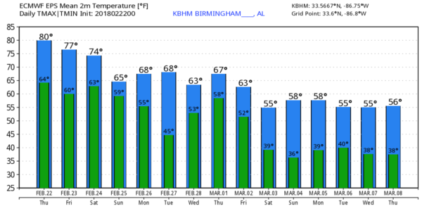
RADAR CHECK: A band of showers and storms is draped over Northwest Alabama this morning, just ahead of a cold front near the northwest tip of the state. The rest of the state is dry, and for most places, today will be just like yesterday. A mix of sun and clouds, record warmth this afternoon with a high around 80 degrees and only isolated showers. The band of rain over Northwest Alabama will diminish later today.
The strong upper ridge will provide another very warm late winter day tomorrow; with a partly sunny sky we rise to near 80 degrees once again, and any showers should be few and far between.
WEEKEND STORMS: The daytime hours Saturday should be warm and mostly dry with only widely scattered showers, but the cold front will get a good nudge, and enter Northwest Alabama late Saturday night. An organized band of showers and thunderstorms will accompany the front, and SPC has defined the standard “slight risk” of severe storms for parts of North and West Alabama, with a “marginal risk” down to Thomasville, Clanton, and Anniston.
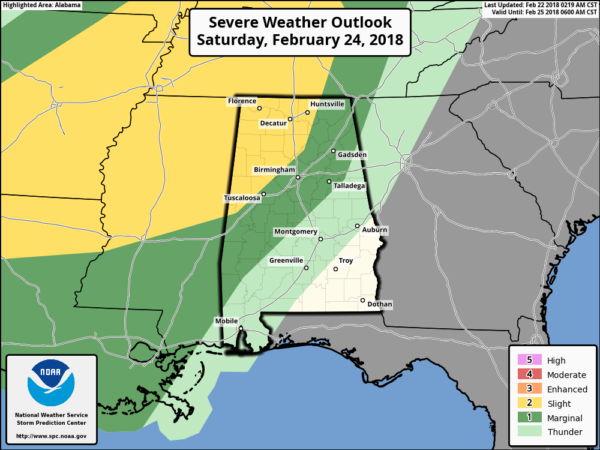
The main window for heavier storms will come from about 12:00 midnight Saturday through 6:00 a.m. Sunday. Thunderstorms will pack a punch as they enter the northwest part of the state late Saturday night; they will have potential for strong winds and small hail. We can’t rule out a small, isolated tornado as well. But, as the storms move deeper into Alabama during the pre-dawn hours Sunday, the air will be more stable, and the better dynamics will lift away to the north. This means the band of storms should slowly weaken as they approach cities like Tuscaloosa, Birmingham, Anniston, and Gadsden. But, as we all know, when it comes to thunderstorms, you have to “expect the unexpected”… so we will keep an eagle eye on radar early Sunday morning.
Rain amounts will be in the 1/2 to 1 inch range with the frontal passage… the rain will end from northwest to southeast Sunday, and the day will be much cooler with a high close to 60 degrees. Many places north of Birmingham won’t get out of the 50s; quite the contrast to the recent warmth.
NEXT WEEK: The front will become stationary over Alabama Sunday night, and we will need to mention a chance of rain Monday for about the southern two-thirds of the state with a high in the 60s. Tuesday looks dry for now, but a chance of showers will return Wednesday and Thursday. Highs for most of the week will be in the 60s.
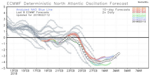
MARCH: The Arctic Oscillation/North Atlantic Oscillation continues to trend negative as we get into March, opening the door for sharp cold snaps. Remember, the average date of the last freeze in Birmingham is April 1, so it is WAY too early to even think about planting anything that would be harmed by a freeze. See the Weather Xtreme video for maps, graphics, and more details.
BEACH FORECAST: Click here to see the AlabamaWx Beach Forecast Center page.
WEATHER BRAINS: Don’t forget you can listen to our weekly 90 minute netcast anytime on the web, or on iTunes. This is the show all about weather featuring many familiar voices, including our meteorologists here at ABC 33/40.
CONNECT: You can find me on all of the major social networks…
Facebook
Twitter
Google Plus
Instagram
Pinterest
Snapchat: spannwx
I will be speaking at Cullman High School this morning… look for the next Weather Xtreme video here by 4:00 this afternoon. Enjoy the day!
Category: Alabama's Weather, ALL POSTS, Weather Xtreme Videos
About the Author (Author Profile)
James Spann is one of the most recognized and trusted television meteorologists in the industry. He holds the AMS CCM designation and television seals from the AMS and NWA. He is a past winner of the Broadcast Meteorologist of the Year from both professional organizations.Subscribe
If you enjoyed this article, subscribe to receive more just like it.


