Rain/Storms Arrive Late Tomorrow Night
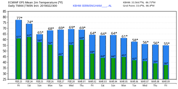
ANOTHER WARM DAY: We are forecasting a high of 80 degrees today; the current record at Birmingham for February 23 is 83 set in 1996. But a high of 80 is still 19 degrees above average for the date. The intense upper high over the Southeast U.S. will keep most places dry today with a partly sunny sky; any showers should be few and far between.
WEEKEND STORMS: I think a decent part of the day tomorrow will be dry; showers should be widely scattered. A warm south wind will increase, averaging 10-20 mph by afternoon. Then, late tomorrow night, the cold front that has been parked just north and west of Alabama will get a southward nudge, and will bring a band of showers and thunderstorms into the state. SPC has a “slight risk” of severe storms defined for Northwest Alabama, west of a line from Huntsville to Jasper to Reform, with a “marginal risk” down to Gadsden, Birmingham, and Reform.
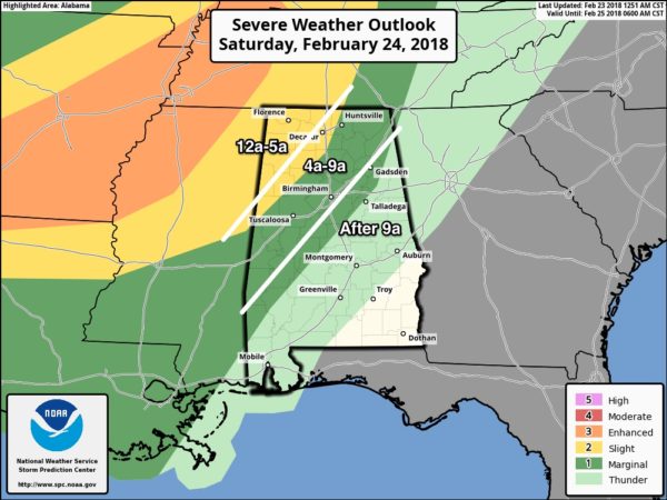
TIMING: Models are trending a tad slower; the main threat for Northwest Alabama will come from midnight tomorrow night through 5:00 a.m. Sunday. For Tuscaloosa, Birmingham, Anniston, and Gadsden, the risk of stronger storms will come after 4:00 a.m.
THREATS: The main threat will come from strong straight line winds across the northwest corner of Alabama late tomorrow night. While one or two small, short lived tornadoes are possible, they are not likely. And, some small hail is not out of the question. The storms should weaken as they move into more stable air over North/Central Alabama early Sunday morning.
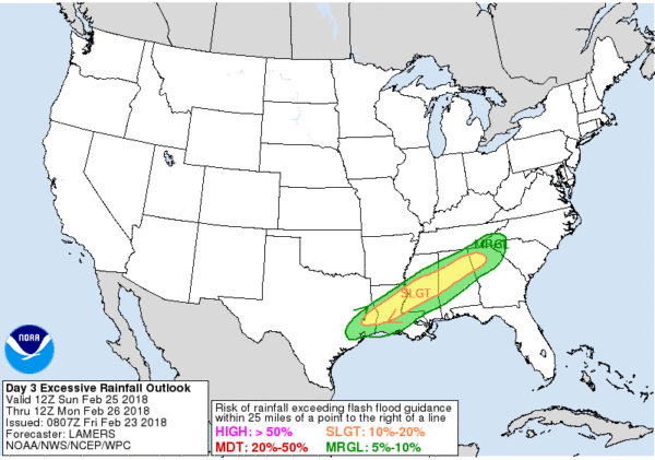
RAIN AMOUNTS: The front will become stationary Sunday, and the chance of rain will continue through the day across a decent part of the state. Rain amounts of 1-2″ are likely, and there could be some localized flooding issues. HPC has a “slight risk” of flooding for parts of North/Central Alabama up in their excessive rain outlook.
We should also note a few strong storms could redevelop Sunday afternoon south of I-59; SPC has a “marginal risk” defined as strong gusty winds will be possible.
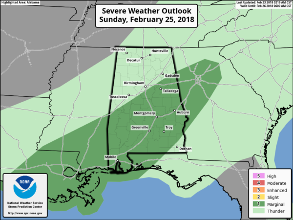
Sunday will be cooler with a high in the 60s.
NEXT WEEK: Lingering showers are possible Monday morning, but for now Monday afternoon and Tuesday look dry. Then, showers are possible Wednesday and Thursday morning, followed by drier, cooler air Friday. See the Weather Xtreme video for maps, graphics, and more details.
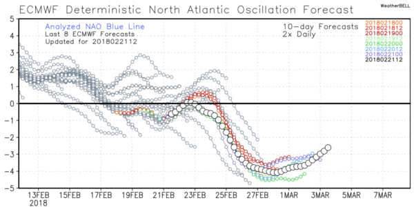
LONG RANGE: We are still looking at a negative Arctic Oscillation/North Atlantic Oscillation combo as we head into March, a pattern that opens for door for sharp cold snaps for the southern and eastern U.S. Too early to be specific, of course.
ON THIS DATE IN 1975: AN EF-4 tornado tore through parts of Tuscaloosa. It first touched down in the Taylorville community and then skipped northeastward before hitting the Skyland Park area and moving on to the McFarland Blvd. exit area of I-59/20. It went on to affect parts of the Alberta City-Leland Park area and then touched down in Holt. The official path length was 14.4 miles. Along it, 289 homes were destroyed or heavily damaged, along with 20 businesses and 21 mobile homes.
The tornado nearly destroyed the new Scottish Inn motel on I-59 at McFarland. The fatality was a 23 year old housekeeper named Thelma Hill, killed when most of the second floor of the motel was sheared away by the tornado causing a wall to fall on her.
BEACH FORECAST: Click here to see the AlabamaWx Beach Forecast Center page.
WEATHER BRAINS: Don’t forget you can listen to our weekly 90 minute netcast anytime on the web, or on iTunes. This is the show all about weather featuring many familiar voices, including our meteorologists here at ABC 33/40.
CONNECT: You can find me on all of the major social networks…
Facebook
Twitter
Google Plus
Instagram
Pinterest
Snapchat: spannwx
I have weather programs today at Trace Crossings Elementary in Hoover, and Cahaba Elementary in Trussville… look for the next Weather Xtreme video here by 4:00 this afternoon. Enjoy the day!
Category: Alabama's Weather, ALL POSTS, Weather Xtreme Videos
About the Author (Author Profile)
James Spann is one of the most recognized and trusted television meteorologists in the industry. He holds the AMS CCM designation and television seals from the AMS and NWA. He is a past winner of the Broadcast Meteorologist of the Year from both professional organizations.Subscribe
If you enjoyed this article, subscribe to receive more just like it.


