Strong Storms Soon To Affect Lawrence, Limestone, Madison, Morgan, Marshall, Jackson, Cullman Counties
Special Weather Statement
National Weather Service Huntsville AL
141 AM CST SUN FEB 25 2018
ALZ004>009-016-TNZ097-250845-
Marshall AL-Lawrence AL-Madison AL-Morgan AL-Limestone AL-Cullman AL-
Jackson AL-Franklin TN-
141 AM CST SUN FEB 25 2018
…SIGNIFICANT WEATHER ADVISORY FOR NORTHWESTERN JACKSON…WEST
CENTRAL MARSHALL…MADISON…SOUTHEASTERN LIMESTONE…NORTHWESTERN
CULLMAN…MORGAN AND SOUTHWESTERN FRANKLIN COUNTIES UNTIL 245 AM
CST…
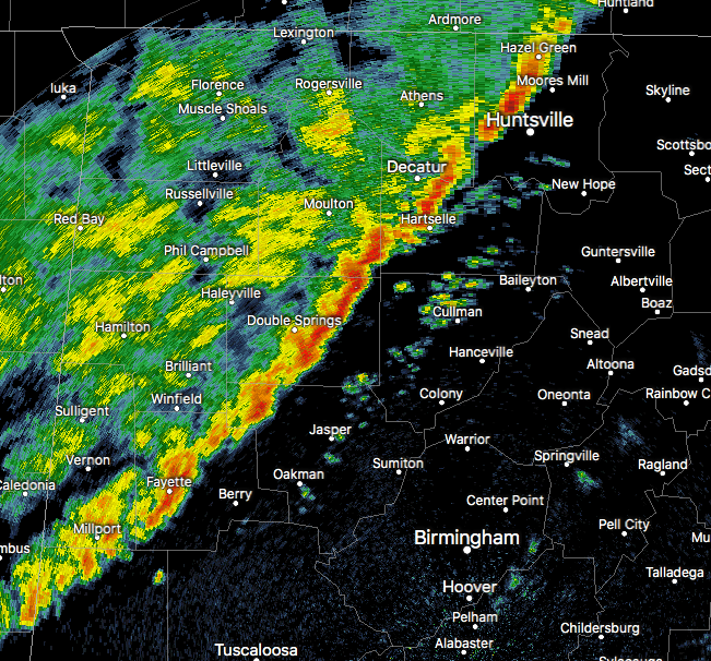
At 141 AM CST, Doppler radar was tracking strong thunderstorms along
a line extending from near Hazel Green to Corinth Rec Area. Movement
was east at 45 mph.
Wind gusts up to 50 mph will be possible with these storms.
Locations impacted include…
Huntsville, Decatur, Madison, Cullman, Hartselle, Moores Mill,
Meridianville, Redstone Arsenal, Hazel Green and Priceville.
PRECAUTIONARY/PREPAREDNESS ACTIONS…
Very heavy rainfall is also occurring with these storms and may lead
to localized flooding. Do not drive your vehicle through flooded
roadways.
Category: Archived Warnings
About the Author (Author Profile)
Scott Martin is an operational meteorologist, professional graphic artist, musician, husband, and father. Not only is Scott a member of the National Weather Association, but he is also the Central Alabama Chapter of the NWA president. Scott is also the co-founder of Racecast Weather, which provides forecasts for many racing series across the USA. He also supplies forecasts for the BassMaster Elite Series events including the BassMaster Classic.Subscribe
If you enjoyed this article, subscribe to receive more just like it.


