Weather Just Spectacular for the Weekend
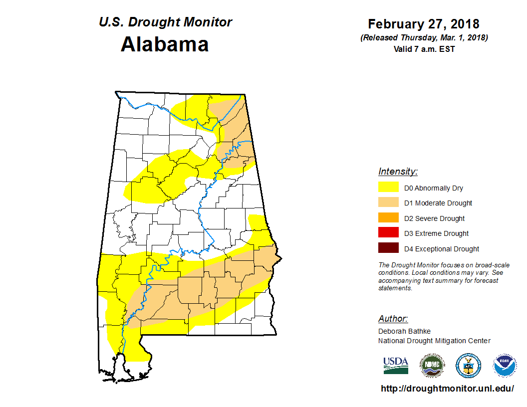
It’s great to see the drought conditions across Alabama much lower thanks to the nice rains we’ve seen during February. The Birmingham Shuttlesworth International Airport recorded 8.14 inches of rain while my gauge saw 7.55 inches. The 30-year average rainfall for February is 4.53 inches.
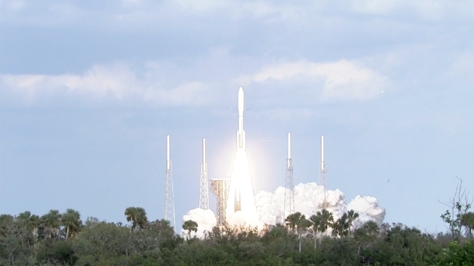
And in case you missed it, the launch of GOES-S on Thursday afternoon occurred successfully. The 197-foot-tall (60-meter) rocket launched at 4:02 p.m. CST (2202 GMT) from Cape Canaveral’s Complex 41 launch pad, and headed east atop 2.1 million pounds of thrust from its RD-180 main engine and four solid rocket boosters. Now it goes through checkouts and testing before being put into service later this year.
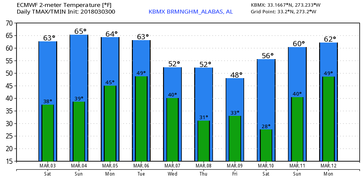
Not a cloud to be found anywhere in the Southeast US this morning. And temperatures are a bit chillier than we’ve seen lately with many locations dipping into the range of 35 to 40 degrees. Lots of sunshine in store for us with a large surface high off to the north keeping a refreshing northerly flow in place with highs climbing into the lower and middle 60s. Much the same weather in store for Sunday with the afternoon highs a trifle warmer as most locations reach the upper 60s.
A strong trough over South Dakota Monday will produce a surface low over eastern South Dakota with a cold front stretching along the Mississippi River Valley into extreme East Texas. Monday should start out dry for us as clouds increase with rain chances ramping up from early afternoon into the evening from the west. Afternoon highs remain warm for Monday with values in the upper 60s.
The front should move fairly quickly through Alabama on Tuesday clearing all by the extreme southeastern counties of the state by midday. Highs will be a little cooler with readings around the 60-degree mark.
The strong upper closed low digging into the Middle Mississippi River Valley on Tuesday will carve out a fairly broad and relatively deep trough across the eastern US for the latter portion of the week. This will bring colder air back into the picture with highs Wednesday and Thursday in the 50s. But the real news will be the morning lows which could be below freezing on Thursday morning. I think there is a really good chance that we’ll see some sort of freeze warning or advisory from the NWS for Thursday and possible Friday mornings.
But as is typically the case in the Southeast US, the trough begins to weaken as ridging takes place over the Central US on Saturday bringing our temperatures back up with highs by Saturday in the lower 60s.
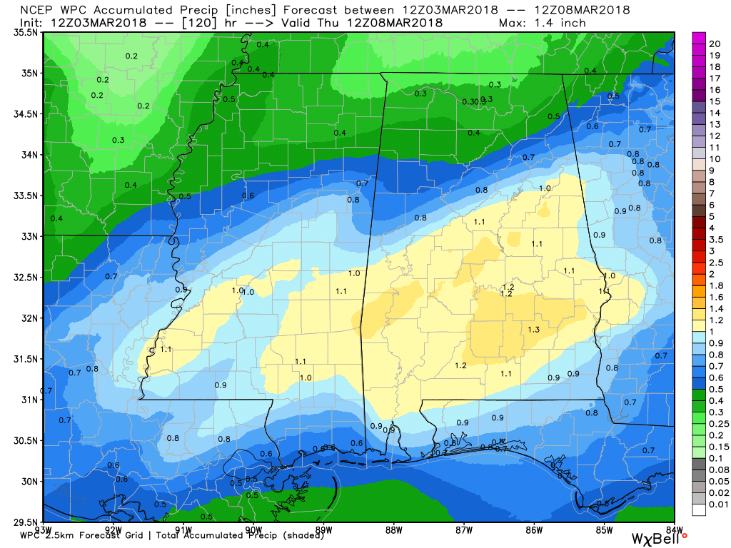
Rainfall amounts for us will be fairly light over the next five days with amounts ranging from a third of an inch in the Tennessee River Valley to around 1.25 inches in the area of Montgomery. This should have a positive effect of reducing drought conditions over South Alabama even further. Limited instability with the system keeps the likelihood of severe storms to the marginal category for Sunday over the Central US (Day 2).
Looking into voodoo country, the GFS progs a fairly strong system to move across the northern US on March 11th helping to create another broad trough over the eastern US by the 14th. A fairly strong upper ridge promises some warm weather around the ides of March (15th) before the flow becomes nearly zonal around the 18th. You can sum up the long range period as active.
Beach Forecast: Click here to see the AlabamaWx Beach Forecast Center page.
WeatherBrains: Don’t forget you can listen to our weekly 90 minute netcast anytime on the web, or on iTunes. This is the show all about weather featuring many familiar voices, including our meteorologists here at ABC 33/40.
Just one more week before Daylight Saving Time begins again. I’ll be filling in this evening for Charles Daniel on ABC 3340 News at 6 and 10 pm, so be sure to tune in for the latest weather forecast. The next Weather Xtreme Video will be posted here on Sunday morning. Enjoy the spectacular weather and Godspeed.
-Brian-
.
Category: Alabama's Weather, ALL POSTS, Weather Xtreme Videos
About the Author (Author Profile)
Brian Peters is one of the television meteorologists at ABC3340 in Birmingham and a retired NWS Warning Coordination Meteorologist. He handles the weekend Weather Xtreme Videos and forecast discussion and is the Webmaster for the popular WeatherBrains podcast.Subscribe
If you enjoyed this article, subscribe to receive more just like it.


