Rain Tonight; Sub-Freezing Temps Thursday/Friday Morning
RAINY NIGHT AHEAD: We have scattered light rain on radar this afternoon, mainly over the eastern half of Alabama, with temperatures in the 60s. Rain will become widespread late tonight as a cold front approaches; rain amounts of around 1/2 inch are likely, with most of the rain coming from about 11:00 tonight through 7:00 a.m. tomorrow. Some thunder is possible, but the air is stable and no severe storms are expected.
The sky becomes mostly sunny tomorrow afternoon as dry air returns to the state; the high tomorrow will be in the mid 60s.
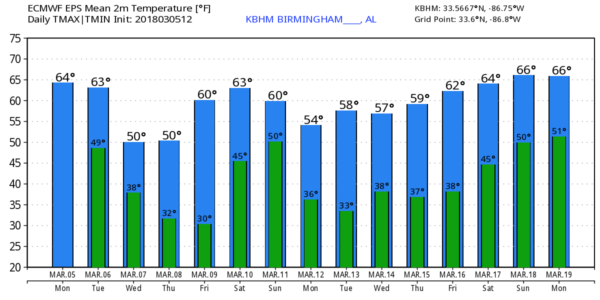
LATE SEASON COLD SNAP: Wednesday will be breezy and much colder; we will struggle to reach the low 50s despite a decent amount of sunshine. We are still forecasting sub-freezing lows Thursday and Friday morning over the northern half of Alabama; most communities will see lows in the 28-32 degree range, with potential for low to mid 20s across colder pockets.
Thursday and Friday will feature a good supply of sunshine both days; the high Thursday will be in the mid 50s, followed by mid 60s Friday.
RAIN RETURNS OVER THE WEEKEND: Clouds increase Friday night, and we will deal with periods of rain over the weekend, along with the possibility of a thunderstorm or two. For now it looks like the most widespread rain will come Saturday afternoon, Saturday night, and into early Sunday morning. The severe weather threat looks very low for now, and rain amounts of 1/2 to 1 inch are likely.
The high Saturday will be in the 60s, but we will struggle to get out of the 40s Sunday with a cold north wind along with lingering clouds.
NEXT WEEK: Looks like we will have more sub-freezing lows early Monday and Tuesday morning of next week as cold air settles into the Deep South. Most of the week looks dry with below average temperatures… see the Weather Xtreme video for maps, graphics, and more details.
ON THIS DATE IN 1963: Voters trekked to the polls in great numbers to vote in the mayor’s race in Birmingham, despite a steady rain. The heated mayoral race pitted attorney Albert Boutwell, Tom King, J.T. Waggoner and Commissioner Bull Conner. Severe storms would develop that day; about 3:35 p.m., a tornado touched down near Bessemer. It moved northeast, remaining on the ground for fifteen miles, tearing through Homewood and into Mountain Brook. Bessemer was the hardest hit, with the worst damage along second and third avenues between 19th and 21st streets. Fortunately, the F3 tornado killed no one, but thirty five people were injured along its path.
BEACH FORECAST: Click here to see the AlabamaWx Beach Forecast Center page.
WEATHER BRAINS: Don’t forget you can listen to our weekly 90 minute netcast anytime on the web, or on iTunes. This is the show all about weather featuring many familiar voices, including our meteorologists here at ABC 33/40. We will produce this week’s episode tonight at 8:30… you watch it live here.
CONNECT: You can find me on all of the major social networks…
Facebook
Twitter
Google Plus
Instagram
Pinterest
Snapchat: spannwx
I had a great time today visiting with the first graders at Ashville Elementary School… be looking for them on the Pepsi KIDCAM today at 5:00 on ABC 33/40 News! The next Weather Xtreme video will be posted here by 7:00 a.m. tomorrow…
Category: Alabama's Weather, ALL POSTS, Weather Xtreme Videos
About the Author (Author Profile)
James Spann is one of the most recognized and trusted television meteorologists in the industry. He holds the AMS CCM designation and television seals from the AMS and NWA. He is a past winner of the Broadcast Meteorologist of the Year from both professional organizations.Subscribe
If you enjoyed this article, subscribe to receive more just like it.


