Unsettled Weekend; Large Hail, Possibly Tornadoes Late Monday for Alabama
There is lots of hyperbole that has developed about Monday’s severe weather situation for Alabama. There is a significant threat of severe weather Monday, but there is lots of uncertainty concerning the modes of severe weather (very large hail, damaging winds and tornadoes). We will try to sort out the details and show our work right here. Welcome to the weather no-hype zone.
POOR WORD CHOICE: Spin zone may be the wrong thing to describe a discussion about potential tornadoes. Hopefully, we will have a lack of spin in the atmosphere Monday. But in any case, large hail is looking as a big threat Monday afternoon and evening.
FOR YOUR SATURDAY: An upper-level impulse is moving across the area this morning, powering an area of rain and a little thunder. Behind this impulse, expect some sunshine through late morning and into the afternoon, pushing temperatures well into the 70s and allowing instability values to rise. But it will be hard to generate much in the way of showers and storms through the afternoon. Any that do manage to form could be strong, but we don’t expect significant severe weather. Finally, a weak cold front will push into the area this evening, triggering a few showers, and maybe a little thunder, but severe weather shouldn’t be a threat.
THEN FOR SUNDAY: The front settles into Central Alabama and stalls. The day will be mostly cloudy, but a little sunshine will push temperatures into the lower 70s by afternoon. Another disturbance will slide eastward across Alabama Sunday night and early Monday morning, triggering a round of extensive rain and some thunder. Rainfall amounts could be pretty decent with this system, totaling over an inch.
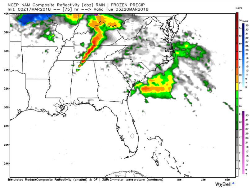
MAIN DAY MONDAY: The warm front will be pulled northward on Monday morning, powered by a low pressure system moving from Missouri into Kentucky. Scattered showers and storms will accompany this passage. A warm and humid airmass will be in place south of the warm front, and some sunshine will push temperatures into the upper 70s. I don’t think it will have a typical stormy feel, with a lack of strong surface winds. But there will be a good supply of instability, decent wind shear and very strong temperature decreases with height. A line of thunderstorms will enter the state during the late afternoon or early evening and will intensify through the evening hours as it pushes southeastward.
FORECAST CONFIDENCE: There is high confidence that large hail will be a significant threat. There is less confidence about the tornado threat. If the NAM is correct, instability will be about 30% higher and wind shear about 30% higher also. This would greatly enhance the tornado threat. As the surface low moves eastward, it will drag a cold front into Alabama.
MONITOR: Now is the time to monitor the very latest forecast information through the weekend and into Monday. The situation should come into clearer focus as we go through the weekend. Don’t fall to the hype machines on social media. It is a situation that bears watching, but nothing to panic about.
TUESDAY TRANSITION: Tuesday will be a breezy and a mix of sun and clouds, and there is a chance for showers and maybe a thunderstorm wrapping around the backside of the low as it departs the southeast. Those showers should be out of the area by the evening. Afternoon highs will be in the lower 60s to the lower 70s, while overnight lows will be in the upper 30s to the mid-40s.
CALMING FOR THE REST OF THE WEEK: The good news is that conditions will be drier for the remainder of the work week, and temperatures will be just below normal for Wednesday and Thursday. Afternoon highs will be in the upper 50s to the mid-60s for those days with a good supply of sunshine. Friday will feature a mix of sun and clouds with slightly warmer temperatures, as highs reaching the lower 60s to the upper 60s.
OUT THERE IN VOODOO LAND: Just past the end of our seven days in this discussion, days 8-14 are trending wetter as we’ll have several different disturbances move through, with a couple of those days possibly featuring stronger storms. These are just trends at this point, not a forecast. That is why we call it Voodoo Land.
GULF COAST WEATHER: Into each life a little rain must fall, even along the beautiful beaches of Alabama and Northwest Florida. It will be mild, however, with highs in the 70s and lows in the 60s before a short-lived cool down arrives at midweek. Water temperatures are in the lower 60s. a href=”http://www.alabamawx.com/?page_id=99654″ target=”_blank”>Click here to see the Beach Forecast Center page.
ADVERTISE WITH US: Deliver your message to a highly engaged audience by advertising on the AlabamaWX.com website. The site enjoyed 18 MILLION pageviews in the past 12 months. Don’t miss out! We can customize a creative, flexible and affordable package that will suit your organization’s needs. Contact me, Bill Murray, at (205) 687-0782 and let’s talk.
WEATHERBRAINS: Monday night, the panel will entertain the inestimable Chuck Doswell (severe weather threat pending though). Check out the show at www.WeatherBrains.com. You can also subscribe on iTunes. You can watch the show live at live.bigbrainsmedia.com. You will be able to see the show on the James Spann 24×7 weather channel on cable or directly over the air on the dot 2 feed.
ON THIS DATE IN 1952: The ban on the word “tornado” fell on March 17, 1952 when the new Severe Local Storm Warning Center issued its first tornado “forecast.” The forecasts were the forerunners of the tornado watches we know today. Follow my weather history tweets on Twitter. I am @wxhistorian at Twitter.com.
Category: Alabama's Weather, ALL POSTS
About the Author (Author Profile)
Bill Murray is the President of The Weather Factory. He is the site's official weather historian and a weekend forecaster. He also anchors the site's severe weather coverage. Bill Murray is the proud holder of National Weather Association Digital Seal #0001 @wxhistorianSubscribe
If you enjoyed this article, subscribe to receive more just like it.


