A Look At The Alabama Severe Weather Situation Sunday/Monday
This is mid-March in Alabama, and we are getting into the core of the spring tornado season. Having severe weather threats here this time of the year is nothing unusual. Here is a review of the situation over the next 72 hours…
TODAY: Scattered showers and storms across Alabama early this morning will end in a few hours, and the late morning and afternoon will be generally rain-free with only isolated showers. The sun should break out at times, and the high will be in the upper 70s. A few spots could touch 80 where the sun stays out longer.
TOMORROW: SPC has defined a severe weather threat for parts of Central and South Alabama tomorrow afternoon and tomorrow night…

A surface front will begin to lift northward, and as an upper trough begins to approach from the west, showers and storms will begin to fire up tomorrow afternoon and tomorrow night. Some of these storms could reach severe limits; the main threats will come from heavy rain and strong gusty winds. Storm relative helicity values will not be particularly strong. Still, a isolated tornado or two is not totally out of the question, especially in the “slight risk” over Southwest Alabama.
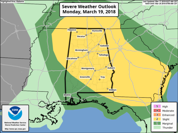
MONDAY: All of Alabama is in a severe weather risk Monday; there is a “marginal” risk over Southwest Alabama, with the standard “slight risk” for the rest of the state.
There has been much hyperbole about this threat across social media; it is very important to understand the magnitude of this threat will be determined by mesoscale (small scale) features, and for now nobody knows exactly how the atmosphere will look after the showers and storms Sunday afternoon and Sunday night. Computer models are not in especially good agreement.
But, if the atmosphere can recover, there could be a significant severe weather threat for at least a part of the state Monday afternoon into Monday evening. SPC states in their discussion “Given the potential for significant severe storms, a categorical upgrade is possible in later outlooks once predictability increases and the centroid of severe coverage is better established.” Once we get a better handle on the mesoscale situation, an upgrade to a higher risk is likely.
For now it looks like all modes of severe weather will be possible Monday, including tornadoes. It is important to note that with forecast steep lapse rates, large hail is a very strong possibility.
As I stated at the top of this post, severe weather threats are VERY common in Alabama in March, April, and May. For any event like this… you need to be ready…
*Be sure you can hear warnings if needed. NEVER rely on an outdoor warning siren; if that is your main way of hearing warnings, you have little hope of hearing them indoors. Have a NOAA Weather Radio in your home or business, and a good app designed for warnings on your smart phone like WeatherRadio by WDT.
*Know the safe place in your home. Small room, lowest floor, away from windows, and near the center of the house. If you live in a mobile home, you have to leave and go to a shelter or site built structure.
*In your safe place, be sure you have a helmet for everyone to wear (not just children)… it is also good for everyone to have a portable air horn, and be sure and wear hard sole shoes.
I am in Indianapolis speaking at a weather conference today; I will be back tomorrow afternoon. Our entire team will keep you updated on the severe weather situation, so keep checking the blog for no-nonsense updates through the weekend.
Category: Alabama's Weather, ALL POSTS, Weather Xtreme Videos
About the Author (Author Profile)
James Spann is one of the most recognized and trusted television meteorologists in the industry. He holds the AMS CCM designation and television seals from the AMS and NWA. He is a past winner of the Broadcast Meteorologist of the Year from both professional organizations.Subscribe
If you enjoyed this article, subscribe to receive more just like it.


