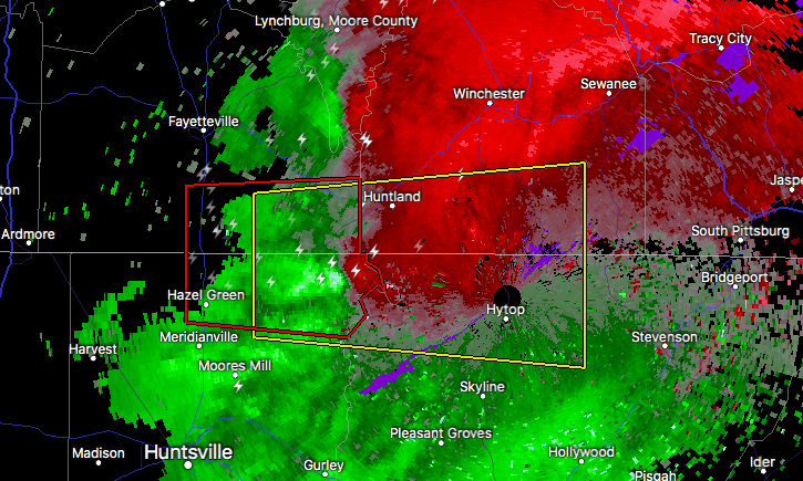
Severe Thunderstorm Warning Issued For Parts Of Jackson, Madison, Franklin (TN), And Lincoln (TN) Counties Until 7:45PM

The National Weather Service in Huntsville Alabama has issued a
* Severe Thunderstorm Warning for…
Northwestern Jackson County in northeastern Alabama…
Northeastern Madison County in north central Alabama…
Southeastern Lincoln County in Middle Tennessee…
Southern Franklin County in Middle Tennessee…
* Until 745 PM CDT
* At 718 PM CDT, a severe thunderstorm was located near New Market, or 11 miles northeast of Moores Mill, moving east at 35 mph.
HAZARD…70 mph wind gusts and quarter size hail.
SOURCE…Radar indicated.
IMPACT…Hail damage to vehicles is expected. Expect considerable tree damage. Wind damage is also likely to mobile homes, roofs, and outbuildings.
* Locations impacted include…
Huntland, New Market, Hytop, Francisco, Beans Creek, Plevna, Jericho, Flintville, Elora and Estillfork.
Category: ALL POSTS
About the Author (Author Profile)
Subscribe
If you enjoyed this article, subscribe to receive more just like it.


