Strong to Severe Storms Still Expected Later Tonight & Into Early Wednesday
Looking at the latest model data that is rolling in and I still believe the forecast is still on point with having the possibility of strong to severe storms rolling through North and Central Alabama starting later this evening through the pre-dawn hours on Wednesday morning.
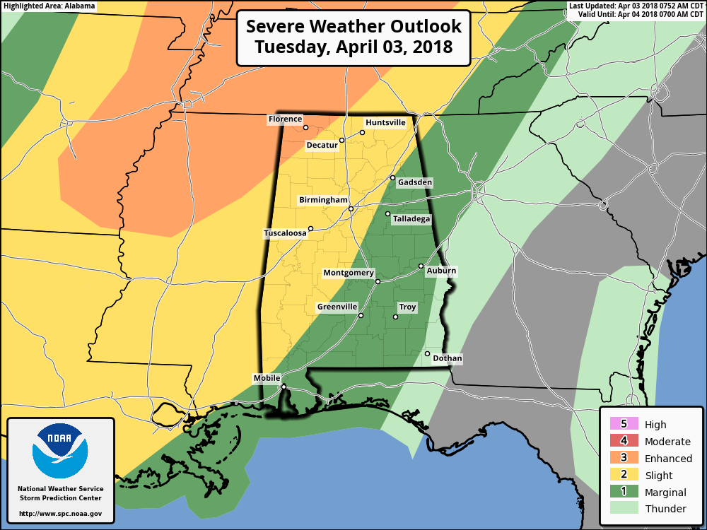
The latest Day 1 Severe Weather Outlook graphic from the Storm Prediction Center continues to show that the northwestern corner of the state has been defined in an Enhanced Risk for severe storms for this evening through the early morning hours on Wednesday. This includes locations west of a line from just west of Elkmont (Limestone Co.) to just west of Town Creek (Lawrence Co.) to Hodges (Franklin Co.) to the Mississippi state line due west of Hamilton. Locations east and south of that has been defined in a Slight Risk for severe storms stretching all the way to a line from Sand Rock (Cherokee Co.) to Pell City (St. Clair Co.) to Clanton (Chilton Co.) to just east of Selma (Dallas Co.). The rest of Central Alabama east of the slight risk has been defined in a Marginal Risk for severe storms with the exception of the extreme southeastern corner of the area.

12z NAM-3k forecast sounding valid at 7PM tonight in NW Alabama.
The main window for strong to severe storms throughout the area will be from around 8:00 PM tonight through roughly 3:00 AM Wednesday. Looks like tonight’s event will be linear in nature, with a line of storms moving into the northwestern parts of the state around 8:00 PM. At that time, instability values will be sufficient in the 1800-2100 J/kg range, and mix that with Downdraft CAPE values at or near 1000 J/kg, there will be the potential for storms with strong downdraft thunderstorm winds up to and exceeding 60 MPH. Helicity values will be sufficient to support rotating updrafts, so therefore a risk for a few brief tornadoes will exist.
As this line moves eastward, it will be in a weakening trend as we continue to lose the heating from the day and instability values continue to steadily decline. With that being said, the threat for damaging thunderstorm wind gusts and a brief tornado will continue through much of North and Central Alabama throughout the remaining hours of Tuesday and into the first few hours of Wednesday.
Timing on impacts from strong to severe storms for locations west of a line from Gadsden to Birmingham to Demopolis will be from around 8:00 PM to 12:00 AM, and east of that same line from 11:00 PM to 3:00 AM. By the time the line of storms reach the I-85 corridor in the southeastern parts of Central Alabama, the threat of severe weather will have diminished (mainly locations east of a line from Roanoke to Dadeville to Montgomery).
We’ll continue to have updates throughout the day on the blog. Be sure to have your safety kits and plans ready to go just in case a warning is issued for your location.
Category: Alabama's Weather, ALL POSTS
About the Author (Author Profile)
Scott Martin is an operational meteorologist, professional graphic artist, musician, husband, and father. Not only is Scott a member of the National Weather Association, but he is also the Central Alabama Chapter of the NWA president. Scott is also the co-founder of Racecast Weather, which provides forecasts for many racing series across the USA. He also supplies forecasts for the BassMaster Elite Series events including the BassMaster Classic.Subscribe
If you enjoyed this article, subscribe to receive more just like it.


