Enhanced Risk Area Expanded In Northwest Alabama; Moderate Risk Just To Our Northwest
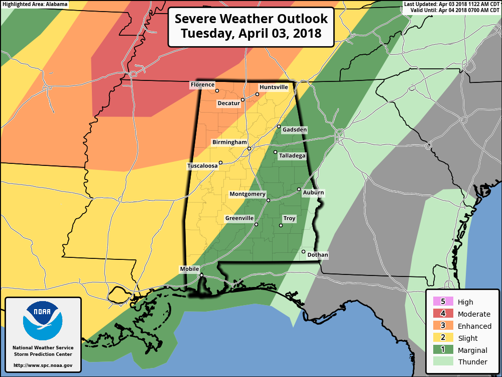
The SPC has expanded the Enhanced Risk of severe storms more to the southeast to now include area east of a line from Hytop (Jackson Co). to Arley (Winston Co.) to just west of Reform (Pickens Co.).
We do note that a Moderate Risk for severe storms clips the very northwestern corner of the state, which includes the Waterloo community in Lauderdale County. The threat for damaging winds will be a little higher in the moderate risk zone, while the tornado risk stays the same as the enhanced risk areas.
A Slight Risk continues for areas east and southeast of that, stretching to a line from Sand Rock (Cherokee Co.) to Pell City (St. Clair Co.) to Clanton (Chilton Co.) to just east of Selma (Dallas Co.).
The rest of Central Alabama east of the slight risk has been defined in a Marginal Risk for severe storms with the exception of the extreme southeastern corner of the area.
Everything is still on track from my previous forecast update post… this update does not affect the timing of the storms or the threats. This just means that the line is possible to hold on strength-wise for a little longer as it moves through the northwestern parts of the state.
Main threats continue to be from damaging straight-line thunderstorm winds of up to and could exceed 60MPH and a few brief tornadoes.
Category: Alabama's Weather, ALL POSTS
About the Author (Author Profile)
Scott Martin is an operational meteorologist, professional graphic artist, musician, husband, and father. Not only is Scott a member of the National Weather Association, but he is also the Central Alabama Chapter of the NWA president. Scott is also the co-founder of Racecast Weather, which provides forecasts for many racing series across the USA. He also supplies forecasts for the BassMaster Elite Series events including the BassMaster Classic.Subscribe
If you enjoyed this article, subscribe to receive more just like it.


