Strong/Severe Storms Arrive Late Tonight
ANOTHER WARM SPRING DAY: We project a high around 80 degrees again today; south winds will increase this afternoon, gusting at times to 30 mph ahead of a cold front. The sky will be mostly cloudy, although the sun should peek out at times. A shower is not totally out of the question during the day, but the main action comes late tonight.
SEVERE STORMS POSSIBLE: SPC has pulled the “enhanced risk” down into the northwest corner of the state for tonight, around the Shoals… the standard “slight risk” extends down to Fort Payne, Birmingham, and Demopolis, and a “marginal risk” is defined to Roanoke, Troy, and Andalusia…
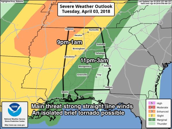
TIMING: A line of strong to severe storms will enter far Northwest Alabama around 9-10 p.m. tonight; the line should reach I-59 (Tuscaloosa, Birmingham, Gadsden) around midnight-1 a.m…. and then places like Anniston and Clanton by 2:00 a.m.
THREATS: The main threat will come from strong, potentially damaging straight line winds. These winds could be strong enough to knock down some trees and power lines. An isolated, small tornado is possible as well, along with small hail.
RAIN: Rain amounts of 1/2 to 3/4″ are expected, not enough for any flooding issues.
The storms should weaken as they move southeast of Birmingham during the pre-dawn hours, encountering a more stable airmass over Central and South Alabama. Be sure you have a good way of hearing warnings late tonight in the event they are needed.
The sky becomes sunny tomorrow, and the day will be windy and much cooler with a high in the 60-65 degree range.
FROST THURSDAY MORNING: We project lows in the mid 30s early Thursday with a clear sky and calm wind; frost should be fairly widespread over the northern half of the state. And, the traditionally colder spots will see another late season freeze. Growers beware. Then, we warm nicely during the day Thursday… with ample sunshine we project a high around 70 degrees.
FRIDAY AND THE WEEKEND: Moisture levels will begin to rise Friday along with an increase in clouds, but for now it looks like any showers will be pretty widely spaced. Friday’s high will be in the 67-70 degree range. Unfortunately Saturday looks wet and cool as a cold front drops southward; some parts of North Alabama will hold in the 50s all day with periods of rain. This won’t be an “all day” kind of rain, but if you have something planned outdoors understand it will rain at times.
Then, Sunday will be much warmer as a warm front lifts north of the state; we reach the mid 70s with a mix of sun and clouds. A shower is possible Sunday, but they should be widely separated.
NEXT WEEK: Monday looks wet with showers and thunderstorms likely as another cold front slices into the state; colder and drier air will return during the mid-week period. Some hint in global models we could drop into the 30s again by Wednesday morning (April 11). See the Weather Xtreme video for maps, graphics, and more details.

ON THIS DATE 44 YEARS AGO: Alabama was one of several states devastated by the “Super Outbreak,” as April 3rd and 4th, 1974, has become known. This date certainly represents one of the darkest times in Alabama weather history. During the late afternoon and evening hours of April 3, 1974, at least eight tornadoes, including four extremely intense and long-lived storms, brought death and extreme storm destruction to Alabama. Eighty-six persons were killed, 949 were injured, and damages exceeded $50 million. Sixteen counties in the northern part of the state were hit the hardest. The most intense tornado, an F5, tore through the heart of Guin, in Marion County, killing 23.
BEACH FORECAST: Click here to see the AlabamaWx Beach Forecast Center page.
WEATHER BRAINS: Don’t forget you can listen to our weekly 90 minute netcast anytime on the web, or on iTunes. This is the show all about weather featuring many familiar voices, including our meteorologists here at ABC 33/40.
CONNECT: You can find me on all of the major social networks…
Facebook
Twitter
Google Plus
Instagram
Pinterest
Snapchat: spannwx
I have weather programs today at American Christian Academy in Tuscaloosa… and North Jefferson Middle School in Kimberly… be looking for the next Weather Xtreme video here by 4:00 this afternoon. Enjoy the day!
Category: Alabama's Weather, ALL POSTS, Weather Xtreme Videos
About the Author (Author Profile)
James Spann is one of the most recognized and trusted television meteorologists in the industry. He holds the AMS CCM designation and television seals from the AMS and NWA. He is a past winner of the Broadcast Meteorologist of the Year from both professional organizations.Subscribe
If you enjoyed this article, subscribe to receive more just like it.


