Rain/Storms Today; Delightful Weekend Ahead
WET IS THE WORD: A strong upper air wave is pushing a large rain mass into Alabama this morning… we expect widespread rain through midday. This afternoon we trend drier, but the air could become unstable over the eastern counties of the state, and SPC maintains a “marginal risk” of severe storms near the Georgia border… for places like Heflin, Wedowee, Roanoke, Lineville, Lafayette, Opelika, and Phenix City…
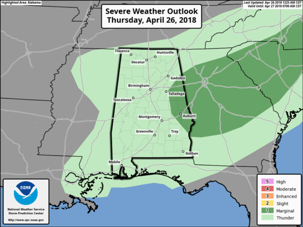
A few storms over East Central Alabama this afternoon could produce some hail and strong gusty winds… the threat of a tornado is very low, but not zero. The main window for the heavier storms there will come from about 1:00 until 5:00 p.m. There is certainly a chance the rain this morning could keep the air stable, and we wind up with no strong/severe storms. But then again this is late April and we have to keep an eye on any dynamic system like this that passes through.
Rain amounts today should be in the 1/2 to 1 inch range for most places, and temperatures will generally hold in the 60s.
TOMORROW AND THE WEEKEND: Tomorrow looks dry and pleasant with a partly sunny sky… a surface front should pass through in dry fashion during the late afternoon or evening hours. Tomorrow’s high will be at or just over 70 degrees. Then, a fine spring weekend is ahead with sunny mild afternoon and clear cool nights. Saturday’s high will be in the mid 70s… then we expect low 70s Sunday as slightly cooler slips in from the north. No rain worries for a change.
RACE WEEKEND: Today will be pretty wet at the Talledega Superspeedway with rain likely this morning, and possibly a strong thunderstorm during the afternoon. The high will be in the 67-70 degree range. For tomorrow it will be a partly sunny day with a high will be close to 70 degrees. Then, the weather could not be any better for the weekend. Sunny Saturday and Sunday; highs in the low 70s Saturday followed by mid 70s Sunday for the Geico 500.
MULLET TOSS: The annual event at the Flora-Bama draws huge crowds, and the weekend on the Gulf Coast will be spectacular. Sunny days, fair nights tomorrow through Sunday with highs in the 70s. Water temperatures in the Gulf are running in the mid 70s this morning (74 at the Dauphin Island Sea Lab).
NEXT WEEK: A developing upper ridge over the eastern third of the nation will bring the warmest weather so far year to our state; we expect upper 70s Monday, low 80s Tuesday and Wednesday, and mid 80s Thursday and Friday. There will be a threat of storms west of here by mid-week, but the ridge holds and we only expect a weakening band of showers and storms by the end of the week Friday or Friday night. See the Weather Xtreme video for maps, graphics, and more details.

ON THIS DATE SEVEN YEARS AGO: The second day of “superoutbreak” of tornadoes, which lasted from April 25-28, 2011. Numerous tornadoes touched down across several states, including Texas, Louisiana, Arkansas. Most of those tornadoes were weak, but a few of them caused considerable damage. A long-tracked wedge tornado caused EF2 damage in rural portions of Texas and Louisiana. An EF3 tornado destroyed multiple structures and caused severe damage at Fort Campbell, Kentucky as well. A total of 55 tornadoes were confirmed the 26th, although no fatalities occurred. The peak of the event, however, would come the next day, April 27.
BEACH FORECAST: Click here to see the AlabamaWx Beach Forecast Center page.
WEATHER BRAINS: Don’t forget you can listen to our weekly 90 minute netcast anytime on the web, or on iTunes. This is the show all about weather featuring many familiar voices, including our meteorologists here at ABC 33/40.
CONNECT: You can find me on all of the major social networks…
Facebook
Twitter
Google Plus
Instagram
Pinterest
Snapchat: spannwx
I have a weather program this morning at Whitesboro Elementary in Etowah County… look for the next Weather Xtreme video here by 4:00 this afternoon. Enjoy the day!
Category: Alabama's Weather, ALL POSTS, Weather Xtreme Videos
About the Author (Author Profile)
James Spann is one of the most recognized and trusted television meteorologists in the industry. He holds the AMS CCM designation and television seals from the AMS and NWA. He is a past winner of the Broadcast Meteorologist of the Year from both professional organizations.Subscribe
If you enjoyed this article, subscribe to receive more just like it.


