Watching the Progress of Alberto
Radars covering Alabama were clear of rain this morning, but our latest satellite view showed the clouds across the Southeast US arcing from the Carolinas across Georgia and Alabama into the Gulf south of Mobile. Clearly we can see the influence of Alberto which was located west of Fort Myers, FL. Much like we saw yesterday afternoon and evening, showers with embedded thunderstorms will develop again today in the moist, unstable air mass across the Southeast US. Storms will likely be moving from east to west with a slight angle to the south of west. Highs will be held to the lower and middle 50s in response to the clouds and showers.

The future course of Alberto, still expected to remain a tropical storm as it approaches landfall in the Florida Panhandle on Monday afternoon has been adjusted eastward. This track is still on the western edge of the ensemble of track plots, so it is quite possible we see additional adjustment with future forecasts.
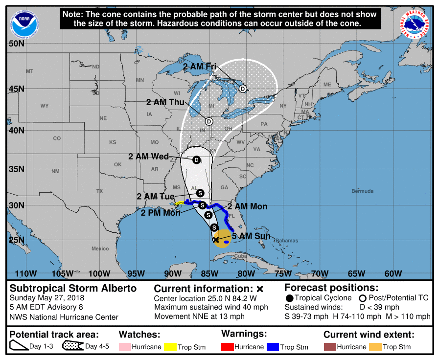
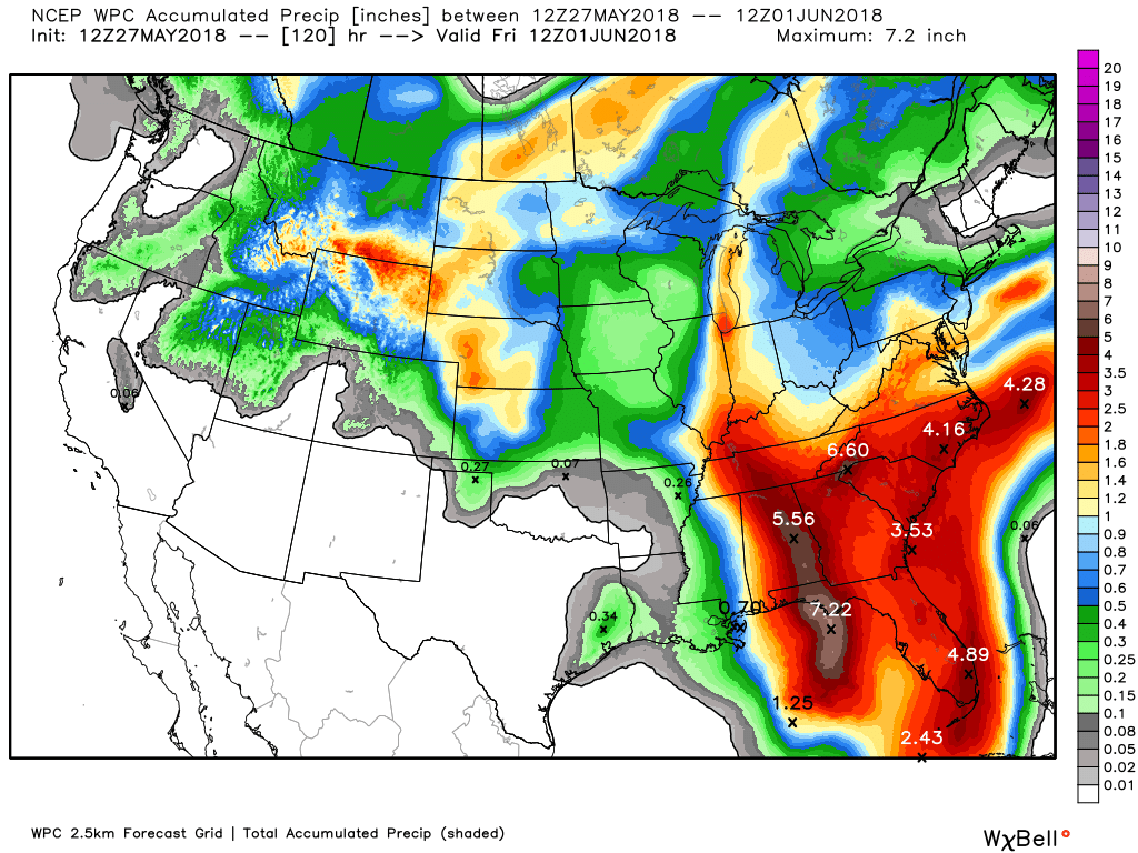
For Central Alabama the big threat is going to come in the form of heavy rain. With the eastward adjustment in the track, the band of heavy rain – in the range of 4 to 6 inches – has also been adjusted eastward stretching in a band about 90 miles wide from Panama City, FL, to Anniston, AL (see graphic below).
Flash flood watches have been posted for much of the Florida Panhandle and Southeast Alabama (those just north Mobile were cancelled this morning). Tropical Storm Warnings have been issued along the Gulf Coast from Mobile, AL, to just north of Fort Myers, FL. Besides heavy rain on the coast this evening and Monday, very dangerous rip currents will occur, so anyone at the Gulf Coast should stay out of the water – this is not the time for swimming.
Conditions on the Gulf Coast will begin improving rapidly on Tuesday as the center of the storm makes its way through Central and North Alabama moving into Middle Tennessee by Wednesday morning.
Monday and Tuesday the rain and clouds should hold our afternoon highs to near 80 with many locations only reaching the upper 70s. Heavy rain may well create localized flash flooding. In their discussion this morning, the NWS forecasters at Birmingham noted that they were not issuing a flash flood watch since they expect the anticipated flooding to be localized. I don’t think wind will be a big issue for North and Central Alabama as Alberto should decrease fairly quickly after making landfall with wind of 20 to 30 mph here with gusts potentially reaching 40 mph. Isolated tornadoes will also be possible along the eastern side of the track.
Wednesday the storm moves up across the Ohio River Valley as we return to those typical diurnal showers for Wednesday and Thursday with highs climbing right back up into the upper 80s.
As I noted yesterday, we may get at least one day off from the moisture as the GFS is forecasting a trough coming across the Great Lakes and digging along the East Coast Friday and Saturday. This should bring some drier air into the Southeast US and perhaps shutting down the daily showers for one day. But only one day before another impulse dives into the trough on Sunday bringing its own supply of moisture and putting showers and thunderstorms back into the forecast. Highs over the weekend in the mid to upper 80s.
Looking out into voodoo, the GFS is showing signs of some heat. The upper trough over the Southeast US Coast on Tuesday stays with us for a couple of days, but by June 7th a large heat ridge is bubbling upward across the Central US. It promises to spread across the Central US by June 10th raising the prospect of some serious heat as we enter the first portion of June.
SEC BASEBALL TOURNAMENT: The 2018 SEC Baseball Tournament continues today at the Hoover Met. Don’t miss some of the best baseball in the country as the top-12 teams will battle it out in Hoover on the road to Omaha. Join us for the indoor FanFest which is free to the public, open each day of the tournament and fun for all ages. Single-session tickets are $18 each for adults and $9 each for kids 3-12. Bleacher seats are first-come, first-served in the General Admission sections. GET YOUR TICKETS HERE!!!
WEATHER BRAINS: Don’t forget you can listen to our weekly 90 minute netcast anytime on the web, or on iTunes. This is the show all about weather featuring many familiar voices, including our meteorologists here at ABC 33/40.
James Spann will be back on Monday morning with the next edition of the Weather Xtreme Video. Be sure to check back here often for unscheduled updates on the changing weather over the Southeast US in response to Alberto. Have a great day and Godspeed.
-Brian-

.
Category: Alabama's Weather, ALL POSTS, Weather Xtreme Videos
About the Author (Author Profile)
Brian Peters is one of the television meteorologists at ABC3340 in Birmingham and a retired NWS Warning Coordination Meteorologist. He handles the weekend Weather Xtreme Videos and forecast discussion and is the Webmaster for the popular WeatherBrains podcast.Subscribe
If you enjoyed this article, subscribe to receive more just like it.


