Deep Tropical Moisture Lingers Over Alabama
FLASH FLOOD WATCH: While Alberto is gone, he left behind a very deep layer of rich tropical moisture, and with a broad upper trough overhead we will maintain a chance of showers and thunderstorms across Alabama today. It won’t rain all day, and the sun will probably peek out at times. But, showers and storms today will be very effective rain producers with high precipitable water values. NWS Birmingham issued another flash flood watch for much of Central Alabama early this morning; it will be in effect until 7pm…
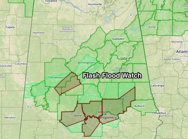
A number of flash flood warnings were in effect at daybreak; some of the heaviest rain was from the Birmingham metro down into Bibb, Hale, and Perry counties. With the ground totally saturated from yesterday’s rain, heavier storms today can easily produce flooding issues. If you live in a flood prone area, pay close attention to warnings. Many creeks and streams will be pushed out of their banks.
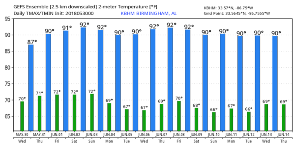
TOMORROW: Storms will be a little more scattered in nature tomorrow, and mostly during the afternoon and evening hours. But, where they form they could pack a punch, SPC has a “marginal risk” of severe weather defined for parts of North Alabama…

Heavier storms tomorrow afternoon could produce small hail and gusty winds. Otherwise, tomorrow will feature a mix of sun and clouds with a high in the 85-88 degree range.
FRIDAY AND THE WEEKEND: We are forecasting some pretty routine early June weather on these three days; partly sunny with “scattered, mostly afternoon and evening showers and thunderstorms”. Afternoon storms will be random, and there is no way of knowing in advance when and where they form. Heat levels will be rising with afternoon highs pretty close to 90 degrees each day.
NEXT WEEK: The GFS continues to suggest drier air will creep into Alabama from the north, meaning showers should be few and far between for the first half of the week with highs in the 86-90 degree range. A surface front could bring a higher chance of showers and storms late in the week… see the Weather Xtreme video for maps, graphics, and more details.
TROPICS: All is quiet across the Atlantic basin, and tropical storm formation is not expected through the next seven days.
BEACH FORECAST: Click here to see the AlabamaWx Beach Forecast Center page.
WEATHER BRAINS: Don’t forget you can listen to our weekly 90 minute netcast anytime on the web, or on iTunes. This is the show all about weather featuring many familiar voices, including our meteorologists here at ABC 33/40.
CONNECT: You can find me on all of the major social networks…
Facebook
Twitter
Google Plus
Instagram
Pinterest
Snapchat: spannwx
Look for the next Weather Xtreme video here by 4:00 this afternoon… enjoy the day!
Category: Alabama's Weather, ALL POSTS, Weather Xtreme Videos
About the Author (Author Profile)
James Spann is one of the most recognized and trusted television meteorologists in the industry. He holds the AMS CCM designation and television seals from the AMS and NWA. He is a past winner of the Broadcast Meteorologist of the Year from both professional organizations.Subscribe
If you enjoyed this article, subscribe to receive more just like it.


