

More Scattered Storms This Afternoon
MORNING SUN, AFTERNOON STORMS: All is quiet across the great state of Alabama early this morning; we expect a good supply of sunshine this morning, followed by the usual round of random, scattered thunderstorms this afternoon and tonight. Most of the storms will come from 1:00 until 11:00 p.m… and with a little dynamic support from the southern edge of the westerlies, they could be pretty strong over the northern counties of the state. SPC has a “slight risk” (level 2 out of 5) defined for the northeast corner of Alabama, with a “marginal risk” (level 1 out of 5) down to Haleyville, Trussville, Pell City, and Roanoke…
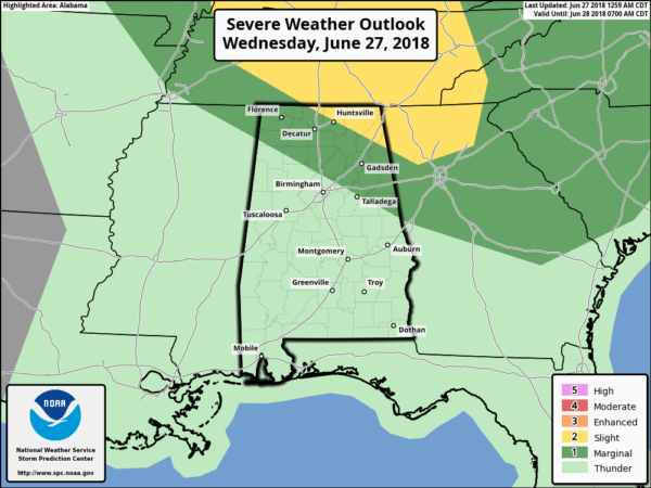
The main threat will come from strong straight line winds, possibly enough in a few spots to knock down trees and power lines. But, understand the storms will still be random and scattered, and it won’t rain everywhere.
It will be another hot summer day; the high will be in the low 90s, and parts of Central Alabama are under a “heat advisory” with potential heat index values peaking near 105 for a brief time before afternoon storms can cool things down.
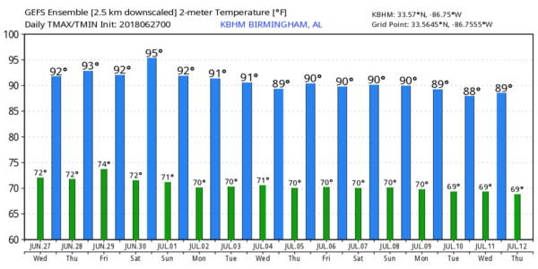
REST OF THE WEEK AND THE WEEKEND: The weather will feature basically more of the same… partly sunny, hot, humid days, and “scattered, mostly afternoon and evening showers and thunderstorms”. The chance of any one spot getting wet most days will be around one in three, and afternoon highs will hold mostly in the low 90s. Just what you expect in late June and early July in Alabama.
NEXT WEEK: The overall synoptic weather pattern won’t change, and accordingly the weather stays the same through most of the week. Hot, humid days with the threat of a passing thunderstorm, mainly during the afternoon and evening hours. Daily storms will be random and scattered, and no way of knowing in advance exactly when and where they pop up. Highs will be at or just over 90 degrees on most days. Again, this is just what we almost always get in July around here. See the Weather Xtreme video for maps, graphics, and more details.
TROPICS: A weak disturbance off the North Carolina coast has only a 10 percent chance of any development over the next five days as it moves out to sea. The rest of the Atlantic basin is very quiet, and if you have trip planned to the Gulf of Mexico beaches from Gulf Shores over to Panama City Beach ahead, you will have no tropical worries for a least the next 7-10 days.
BEACH FORECAST: Click here to see the AlabamaWx Beach Forecast Center page.
WEATHER BRAINS: Don’t forget you can listen to our weekly 90 minute netcast anytime on the web, or on iTunes. This is the show all about weather featuring many familiar voices, including our meteorologists here at ABC 33/40.
CONNECT: You can find me on all of the major social networks…
Facebook
Twitter
Google Plus
Instagram
Pinterest
Snapchat: spannwx
Look for the next Weather Xtreme video here by 4:00 this afternoon… enjoy the day!
Category: Alabama's Weather, ALL POSTS, Weather Xtreme Videos
About the Author (Author Profile)
James Spann is one of the most recognized and trusted television meteorologists in the industry. He holds the AMS CCM designation and television seals from the AMS and NWA. He is a past winner of the Broadcast Meteorologist of the Year from both professional organizations.Subscribe
If you enjoyed this article, subscribe to receive more just like it.


