

Afternoon Showers/Storms More Numerous Today
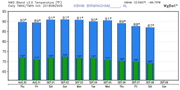
MORNING SUN, AFTERNOON STORMS: The upper ridge over the southern U.S. will weaken a bit in coming days… this means a general increase in the number of showers and thunderstorms during the afternoon and evening hours. Chance of any one community seeing rain today is around 50 percent, and close to 60 percent tomorrow and Friday. Most of the storms will come from about 12:00 noon to 10:00 p.m. Otherwise, look for a mix of sun and clouds each day with a high between 88 and 91 degrees.
THE WEEKEND: The ridge strengthens again, so afternoon showers and storms should become fewer in number Saturday and Sunday with afternoon highs close to 90 degrees. Risk of any one place seeing rain both days will fall into the 20/30 percent range. The sky will be partly sunny.
FOOTBALL WEATHER: For high school games tomorrow night and Friday night, the weather will be warm and humid with the risk of a thunderstorm, mainly during the first half of the games. Temperatures will be in the upper 70s at kickoff for most stadiums, falling into the mid 70s.
UAB kicks off the season with a Thursday night special tomorrow night at Legion Field in Birmingham… they host Savannah State (kickoff is at 7p CT). A passing shower or storm is possible during the first half of the game, otherwise a humid night with temperatures falling through the mid to upper 70s.
Saturday, Auburn takes on Washington in Atlanta in Mercedes Benz Stadium (2:30p CT kickoff). Outside the domed stadium, afternoon temperatures will be in the 87-90 degree range with the risk of a shower or thunderstorm.
Then, Saturday evening, Alabama will take on Louisville in Orlando (7:00p CT kickoff). The weather will be humid, and a shower or thunderstorm is possible during the game, especially during the first half. Kickoff temperature in the low 80s, falling into the upper 70s by the final whistle.
NEXT WEEK: It looks pretty routine for the first week of September; hot, humid days with a partly sunny sky and “widely scattered, mostly afternoon and evening showers and thunderstorms”. Highs will be around 90 degrees… see the Weather Xtreme video for maps, graphics, and more details.
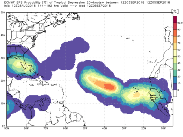
TROPICS: The Atlantic basin remains quiet, but we are seeing signals in global model output that the tropics could wake up in early September. Just something to watch for now…
ON THIS DATE IN 2005: Hurricane Katrina made landfall over Southeast Louisiana at category three strength. Overall, at least 1,245 people died in the hurricane and subsequent floods, making it the deadliest United States hurricane since the 1928 Okeechobee hurricane. Severe property damage occurred in numerous coastal areas, such as Mississippi beachfront towns where boats and casino barges rammed buildings, pushing cars and houses inland; water reached 6–12 miles from the beach. Total property damage was estimated at $125 billion, roughly four times the damage wrought by Hurricane Andrew in 1992, tying Katrina with Hurricane Harvey of 2017 as the costliest Atlantic tropical cyclone on record.
BEACH FORECAST: Click here to see the AlabamaWx Beach Forecast Center page.
WEATHER BRAINS: Don’t forget you can listen to our weekly 90 minute netcast anytime on the web, or on iTunes. This is the show all about weather featuring many familiar voices, including our meteorologists here at ABC 33/40.
CONNECT: You can find me on all of the major social networks…
Facebook
Twitter
Instagram
Pinterest
Snapchat: spannwx
Look for the next Weather Xtreme video here by 4:00 this afternoon… enjoy the day!
Category: Alabama's Weather, ALL POSTS, Weather Xtreme Videos
About the Author (Author Profile)
James Spann is one of the most recognized and trusted television meteorologists in the industry. He holds the AMS CCM designation and television seals from the AMS and NWA. He is a past winner of the Broadcast Meteorologist of the Year from both professional organizations.Subscribe
If you enjoyed this article, subscribe to receive more just like it.


