Eyes On Gordon In The Gulf
HOT LABOR DAY AFTERNOON: Temperatures are pretty close to 90 degrees on the Labor Day afternoon across Alabama… showers are small, and rather isolated. They are moving to the west/northwest, and will dissipate once the sun goes down later this evening.
Our weather through mid-week will be determined by the behavior of Tropical Storm Gordon, now in the far southeast Gulf of Mexico. Here is the latest…
RIGHT NOW: Gordon is packing sustained winds of 50 mph, and the center is west of Naples, Florida. The tropical storm is moving west/northwest at 16 mph. Tropical-storm-force winds extend outward up to 45 miles from the center.

WATCHES/WARNINGS: A Hurricane Warning has been issued from the Mouth of the Pearl River to the Alabama-Florida Border. This warning replaces the Hurricane Watch and Tropical Storm Warning for this area. A Storm Surge Warning is in effect for Shell Beach to Dauphin Island.
FORECAST TRACK: Gordon is expected to move into the Central Gulf Coast, near the Alabama/Mississippi border, tomorrow evening as category one hurricane with 75 mph winds.

COASTAL IMPACT: The primary threat for the Central Gulf Coast is rain; rain amounts of 3-5″ are likely from Pensacola to New Orleans; flash flood watches are in effect. SPC now has put that same general area under a “marginal risk” (level 1/5) for tomorrow afternoon and tomorrow night due to the potential for a few isolated tornadoes or waterspouts. Storm surge flooding is possible along and east of the landfall point; a surge of 2-4 feet is expected along the Alabama Gulf Coast.
Winds on the Alabama coast will be in the 35-55 mph range late tomorrow and tomorrow night, with gusts possible to hurricane force (74 mph).
The weather on the coast will begin to improve Wednesday morning, and the rest of the week will feature routine weather with the usual mix of sun and scattered storms.
INLAND IMPACT: Most of the really widespread rain directly associated with Gordon will fall over Southwest Alabama, generally south of a line from Butler to Monroeville to Florala. Only widely scattered showers are expected for North and East Alabama…
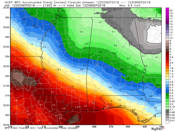
We will mention mostly scattered showers for the western half of the state tomorrow and Wednesday; best chance of seeing rain will be south of I-20 and west of I-65. Showers over North and East Alabama will be few and far between.
REMEMBER: Tropical storm forecasts can, and often will change… so keep an eye on the blog for updates over the next 36 hours. We will post frequently.
THURSDAY/FRIDAY: Partly to mostly sunny both days with only isolated showers around; the high will be very close to 90 degrees. Deeper moisture associated with the remnants of Gordon will be well to the west.
THE ALABAMA WEEKEND: Saturday looks hot and mostly dry with only isolated showers; the high will be near 90 with a good supply of sunshine. We will bring in the chance of scattered showers and thunderstorms over the northern third of the state Sunday as a surface front drifts down into Tennessee; otherwise Sunday will feature a mix of sun and clouds with a high in the upper 80s.
NEXT WEEK: Scattered showers and storms are possible for the first half of the week as the front stalls out near the Alabama/Tennessee border… but unfortunately no sign of any really good push of cool air into our state. The first really good fall front usually arrives in late September. See the Weather Xtreme video for maps, graphics, and more details.

FLORENCE: Tropical Storm Florence in the Atlantic is packing sustained winds of 65 mph… it is far from land at this point.

The GFS global model recurves Florence into the open Atlantic, but the European model builds a blocking high to the north of the system, and pushes Florence toward the U.S. East Coast as a hurricane. It is simply to early to know which solution is correct, but those on the U.S. Atlantic coast need to keep a close eye on this one.
And, a wave now off the coast of Africa has potential to become a tropical depression or storm later this week.
BEACH FORECAST: Click here to see the AlabamaWx Beach Forecast Center page.
WEATHER BRAINS: Don’t forget you can listen to our weekly 90 minute netcast anytime on the web, or on iTunes. This is the show all about weather featuring many familiar voices, including our meteorologists here at ABC 33/40.
CONNECT: You can find me on all of the major social networks…
Facebook
Twitter
Instagram
Pinterest
Snapchat: spannwx
Look for the next Weather Xtreme video here by 7:00 a.m. tomorrow…
Category: Alabama's Weather, ALL POSTS, Weather Xtreme Videos
About the Author (Author Profile)
James Spann is one of the most recognized and trusted television meteorologists in the industry. He holds the AMS CCM designation and television seals from the AMS and NWA. He is a past winner of the Broadcast Meteorologist of the Year from both professional organizations.Subscribe
If you enjoyed this article, subscribe to receive more just like it.


