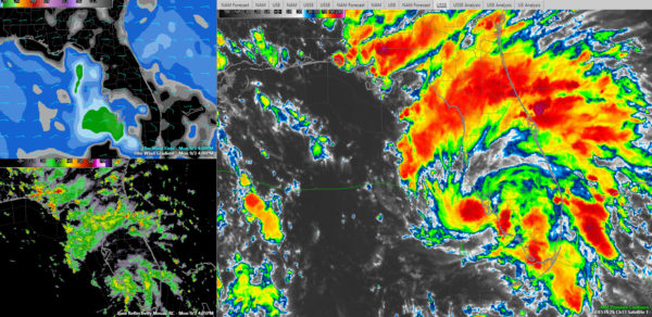
A Few Afternoon Notes on Tropical Storm Gordon
Now that we have the 4 p.m. advisory, here are a few notes on Tropical Storm Gordon:
…Not much change in the vitals. Top winds 50 mph still, pressure 1006 millibars.
…We haven’t had a reconnaissance fix since 12:51 p.m. The plane did find that surface winds were approaching 60 mph then, but the inner core has weakened since then, so the NHC kept the winds at 50 mph.
…Another Air Force Reserve Hurricane Hunter plane is due to leave any time from Biloxi. It should be in the vicinity of the storm’s center around 6 p.m. or so.
…A NOAA plane is in the vicinity of Gordon right now.
…Satellite data indicates that Gordon is still struggling to build an inner core. Tropical cyclones are like steam engines. They huff and puff and gradually build deeper convection. Much of the convection is still on the eastern side of the storm, but convection is beginning to wrap around the northern semicircle now according to radars along the West Coast of Florida as well as GOES-16 satellite data.
…Well to the north of Gordon’s center, strong storms are moving westward across much of the Florida Panhandle at this hour. They are affecting areas from Destin to Panama City. They will move westward along the coast for the next few hours.
…The outflow does not appear to be very good at this time, but as it pulls away from the Florida Peninsula, it will be in a low shear environment.
…There has been a strong anticyclone over the Central Gulf, which is usually good for the outflow, but that strong high has been causing moderate shear. We have been monitoring to see if that shear weakens with time as Gordon approaches from the southeast. That appears to be the case.
…It is over very warm water as well, so gradual strengthening should occur.
…Gordon is now forecast to become a hurricane late tomorrow before making landfall tomorrow night.
…The model guidance is generally a little left of the official forecast track, which was not changed. It still shows landfall near Biloxi around midnight tomorrow night.
…A hurricane warning is now in effect from the Mouth of the Pearl River to the Alabama/Florida border. A storm surge warning is in effect from Shell Beach near New Orleans to Dauphin Island.
…Tropical storm force winds should begin along the Alabama/Mississippi coast by late afternoon tomorrow. If the official track works out, strong tropical storm force winds will impact the Mississippi coast with a small area of hurricane force winds arriving after 10 pm tomorrow night.
…A more easterly track would mean tropical storm force winds would arrive by early afternoon at Destin and Fort Walton and at Orange Beach and Gulf Shore by mid-afternoon. Strong tropical storm force winds would impact the area from Gulf Shores to Navarre by late afternoon, overspread much of Baldwin County and the City of Mobile during the evening. There could be hurricane force winds in a small area near the center between Gulf Shores and Pensacola Beach.
…These wind impacts will be dictated by where the center finally moves inland. If a more westerly track is taken, tropical storm force winds could miss the entire Alabama and Northwest Florida coast.
…Gordon will have a fairly small wind field.
…Storm surge above dry ground is expected to reach 3-5 feet along the Mississippi coast over to Dauphin Island with 2-4 feet in Mobile Bay over to Navarre. The eastern parishes of the New Orleans area, like St. Bernard and Plaquemines, could see 2-4 feet of surge.
…There will be a high risk of rip currents all along the coast.
…4-6 inches of rain is expected across southern Alabama, Central and southern Mississippi into northern Louisiana.
…Tornadoes are posisble tonight across the Florida Peninsula.
FLORENCE
…We will eventually have to contend with Hurricane Florence along the U.S. Southeast Coast, at leat if youbelieve the European model, which swings it around to affect the coasts of Georgia or Northeast Florida around September 13th.


