A Quick Check On Our Weather At Midday
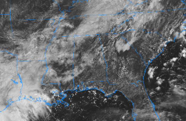
Much of Central Alabama is enjoying mostly cloudy skies at this point, but we do have some thicker cloud cover over parts of the area. Only a few isolated showers are over parts of Clay and Randolph counties, while the rest of the area is dry. Temperatures are in the lower 70s in the northwest to the upper 80s in the southeast. Haleyville is at 73 degrees as the cool spot north of the cold front, while Eufaula is south of the cold front sitting in bright sunshine at 89 degrees. Birmingham was at 81 degrees.

For the remainder of the afternoon and into the early evening hours, skies will be partly cloudy to the north of the I-20 corridor and should remain mainly dry, but an isolated shower is possible. Along and south of the I-20 corridor, scattered shower and storm chances gradually increase from 20% to 50% as you move southward. Afternoon highs will top out in the lower 80s in the northwest to the lower 90s in the southeast. For this evening and throughout the overnight hours, any shower/storm activity should dissipate completely before midnight, leaving us with partly to mostly cloudy skies. Lows will be in the mid-60s to the lower 70s from northwest to southeast.
LOOK BEFORE YOU LOCK
Never leave children, disabled or elderly adults, or pets in parked vehicles. Studies have shown that the temperature inside a parked vehicle can rapidly rise to a dangerous level for children, pets, and even adults. Leaving the windows slightly open does not significantly decrease the heating rate. The effects can be more severe on children because their bodies have not developed the ability to efficiently regulate internal temperature. Heat-related deaths are preventable, so look before you lock.
ON THIS DAY IN WEATHER HISTORY
1961 – Very large and slow-moving Hurricane Carla made landfall near Port Lavaca TX. Carla battered the central Texas coast with wind gusts to 175 mph, and up to 16 inches of rain, and spawned a vicious tornado which swept across Galveston Island killing eight persons. The hurricane claimed 45 lives and caused 300 million dollars damage. The remnants of Carla produced heavy rain in the Lower Missouri Valley and southern sections of the Upper Great Lakes Region.
BEACH FORECAST CENTER
Get the latest weather and rip current forecasts for the beaches from Fort Morgan to Panama City on our Beach Forecast Center page. There, you can select the forecast of the region that you are interested in.
WE’RE HAVING A RECORD-BREAKING YEAR… ADVERTISE WITH US TODAY!
Don’t miss out! We have enjoyed over 14 million page views on AlabamaWx.com since the start of 2018. We can customize a creative, flexible and affordable package that will suit your organization’s needs. Contact Bill Murray at (205) 687-0782.
E-FORECAST
Get the AlabamaWx Weather Blog’s Seven-Day Forecast delivered directly to your inbox by email twice daily. It is the most detailed weather forecast available in Central Alabama. Subscribe here… It’s free!
WEATHERBRAINS:
Don’t forget you can listen to our weekly 90 minute netcast anytime on the web at WeatherBrains.com or on iTunes, Stitcher, or Spotify. This is the show all about weather featuring many familiar voices, including the meteorologists at ABC 33/40.
Category: Alabama's Weather, ALL POSTS
About the Author (Author Profile)
Scott Martin is an operational meteorologist, professional graphic artist, musician, husband, and father. Not only is Scott a member of the National Weather Association, but he is also the Central Alabama Chapter of the NWA president. Scott is also the co-founder of Racecast Weather, which provides forecasts for many racing series across the USA. He also supplies forecasts for the BassMaster Elite Series events including the BassMaster Classic.Subscribe
If you enjoyed this article, subscribe to receive more just like it.


