Warm and Dry for Mid-September
Clear skies this morning as Florence remained drifting into western sections of South Carolina. Temperatures remained mild and somewhat summer-like with lows in the lower half of the 70s. Look for partly cloudy weather across much of Alabama today with highs again climbing into the lower 90s. A few showers are possible in the northeast quadrant of the state due to the proximity of Florence.

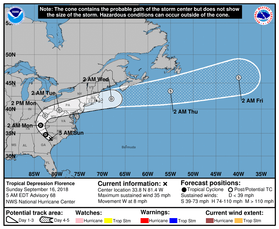
Tropics: Florence, now a depression, continued to produce severe freshwater flooding across parts of the Carolinas; it sure looks like rain totals could be in excess of 3 feet in spots as rain gradually comes to an end for the Carolinas later today. The system continued to drift through western South Carolina, still producing heavy rain while the wind field weakens.
Florence will have very little impact on Alabama’s weather besides than keeping most of us dry and perhaps producing a shower or two in the northeast corner of the state.
Tropical storms Joyce and Helene were in the eastern Atlantic and were moving north to northeast and are no threat to North America.
High pressure migrates across our area to keep our weather sunny and dry through much of the week ahead. An upper ridge will be the primary feature in our weather pattern through the end of next week. The remnants of Florence slowly move northwest and north before becoming an open wave and accelerating into the Atlantic by Wednesday.
The dry pattern keeps rainfall totals very light. This is perhaps not the best conditions for us to enter October which is the driest month of the year for Alabama.

A trough in the westerlies moves into the Great Lakes region by the end of the week trailing a cold front into the Mid South region. This along with increased moisture will bring isolated showers back into the forecast for Friday and into next weekend. Temperatures all week should be in the range of 89 to 92 as summer holds tough. There is some promise to slightly lower temperatures with added moisture and clouds Friday and Saturday.
Looking out into voodoo, we get to follow the movements of a substantial trough as it migrates eastward through the Mississippi River Valley around the 29th. The GFS promises a big change with with the passage of the trough across the eastern US into the first of October.
Beach Forecast: Click here to see the AlabamaWx Beach Forecast Center page.
WeatherBrains: Don’t forget you can listen to our weekly 90 minute netcast anytime on the web, or on iTunes. This is the show all about weather featuring many familiar voices, including our meteorologists here at ABC 33/40.
Thanks for tuning in. James Spann will have the next Weather Xtreme Video posted here by 7 am or so on Monday. You can catch the latest forecasts on ABC 3340 at 5 and 10 pm this evening as I fill in for Charles Daniel. Have a great Sunday and Godspeed.
-Brian-

Category: Alabama's Weather, ALL POSTS, Weather Xtreme Videos
About the Author (Author Profile)
Brian Peters is one of the television meteorologists at ABC3340 in Birmingham and a retired NWS Warning Coordination Meteorologist. He handles the weekend Weather Xtreme Videos and forecast discussion and is the Webmaster for the popular WeatherBrains podcast.Subscribe
If you enjoyed this article, subscribe to receive more just like it.


