Dangerous Hurricane Michael Heads For The Florida Coast; Cooler Air in Alabama Thursday
EYES ON MICHAEL: Alabama’s weather won’t change much today; high clouds will increase ahead of Hurricane Michael in the Gulf of Mexico, and a few scattered showers will develop today and tonight, but nothing especially widespread. We reach the low to mid 80s this afternoon; the average high for October 9 at Birmingham is 77.
Showers will be more numerous tomorrow as Michael moves inland, but rain amounts over much of North and Central Alabama will be fairly light… under 1/2″ for most places. Winds will be less than 20 mph for the northern half of the state as the main impact comes across Southeast Alabama.
MICHAEL THIS MORNING: Michael is now a category two hurricane with sustained winds of 100 mph in the Gulf of Mexico. Strengthening is expected today, and Michael is expected to become a dangerous, category three hurricane tonight. Landfall is forecast tomorrow on the Florida coast near, or just east of Panama City Beach.
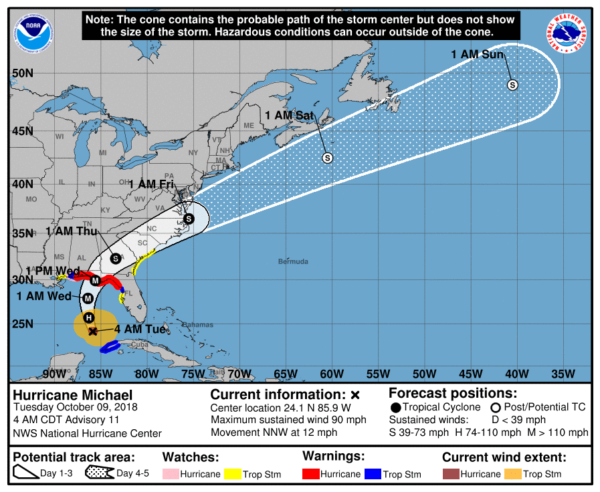
*A Hurricane Warning is in effect from the Alabama/Florida border to Suwannee River Florida. Everyone in these areas should prepare for life-threatening winds associated with the core of Michael. Damaging winds will also extend inland across portions of the Florida Panhandle, southern Georgia, and Southeast Alabama as Michael moves inland.
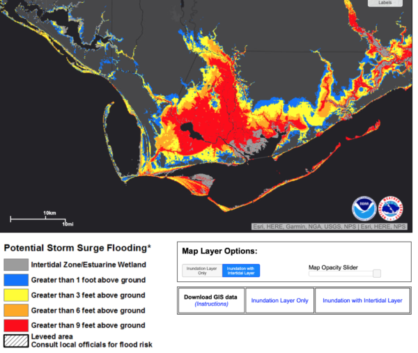
*A Storm Surge Warning is in effect from the Okaloosa/Walton County line to Anclote River Florida. Life-threatening storm surge is likely along portions of the coasts of the Florida Panhandle, Big Bend, and Nature Coast. Residents in these areas should follow all advice given by their local officials.
*Hurricane-force winds extend outward up to 40 miles from the center and tropical-storm-force winds extend outward up to 195 miles.
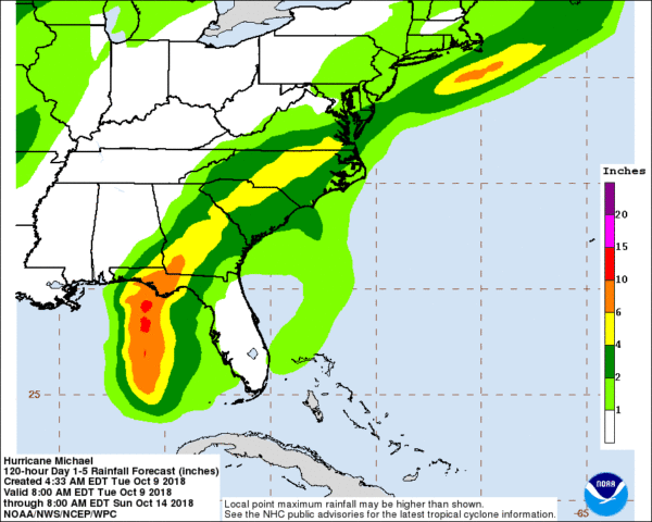
*Heavy rainfall from Michael could produce life-threatening flash flooding from the Florida Panhandle and Big Bend region into portions of Georgia and South Carolina.
*A few tornadoes are possible tomorrow and tomorrow night across parts of North Florida and South Georgia.
*The Alabama Gulf Coast, and Pensacola/Navarre will be on the “good” west side of the circulation. Winds could gust to 45 mph tomorrow and tomorrow night there, but there will be no storm surge issues no tornado threat, and no structural damage. Rain amounts in these areas should be under 2 inches… some some places under one inch. However, dangerous rip currents are likely through tomorrow night.
*The main impact in Alabama will come over the southeast part of the state. Houston and Geneva counties are under a hurricane warning; winds there could gust to 75 mph, potentially knocking down many trees and power lines. Tropical storm force winds (39 mph or higher) are possible as far north as Greenville, Troy, and Eufaula. Rain amounts of 4-6 inches are possible over the southeast corner of the state; a flash flood watch is in effect.
*Michael will not stall; it will move along at a good pace. So, the weather improves greatly on the Gulf Coast Thursday with sunshine returning. The weather there will be beautiful Thursday through the weekend with sunny days and fair nights… perfect conditions for the National Shrimp Festival in Gulf Shores.
*We still encourage you to watch for any potential forecast changes over the next 24 hours as Micheal gets closer to the coast.
COOL CHANGE: For Alabama, any lingering showers will end early Thursday morning, and we will forecast a clearing sky, and big change to cooler temperatures with highs only in the low 70s. Then, we are forecasting delightful weather Friday through the weekend with sunny pleasant days and clear cool nights. Many places will visit the 40s early Friday and Saturday morning; the high Friday will be near 70, followed by low 70s Saturday and upper 70s Sunday.
Showers are possible Sunday night and Monday with a cold front; moisture will be limited, and rain amounts should be light. Then, another shot of cooler air blows into the Deep South by Tuesday and the middle of next week. See the ABC 33/40 Weather Blog for maps, graphics, and more details.
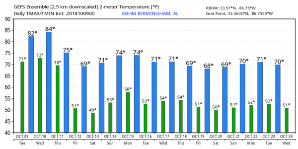
RACE WEEKEND AT TALLADEGA: Beautiful weather for the big weekend; sunny pleasant days, fair cool nights Friday through Sunday with highs in the 70s and lows in the upper 40s and low 50s. It now looks like showers associated with the next cold front will hold off until Sunday night or Monday.
BEACH FORECAST: Click here to see the AlabamaWx Beach Forecast Center page.
WEATHER BRAINS: Don’t forget you can listen to our weekly 90 minute show anytime on your favorite podcast app. This is the show all about weather featuring many familiar voices, including our meteorologists here at ABC 33/40.
CONNECT: You can find me on all of the major social networks…
Facebook
Twitter
Instagram
Pinterest
Snapchat: spannwx
I will be speaking today at Concord Highland Baptist Church (senior adult group)… look for the next Weather Xtreme video here by 4:00 this afternoon. Enjoy the day!
Category: Alabama's Weather, ALL POSTS, Tropical, Weather Xtreme Videos
About the Author (Author Profile)
James Spann is one of the most recognized and trusted television meteorologists in the industry. He holds the AMS CCM designation and television seals from the AMS and NWA. He is a past winner of the Broadcast Meteorologist of the Year from both professional organizations.Subscribe
If you enjoyed this article, subscribe to receive more just like it.


