Michael Strengthens Into A Major Hurricane, Continues On Track To The Gulf Coast
THE LATEST ON HURRICANE MICHAEL
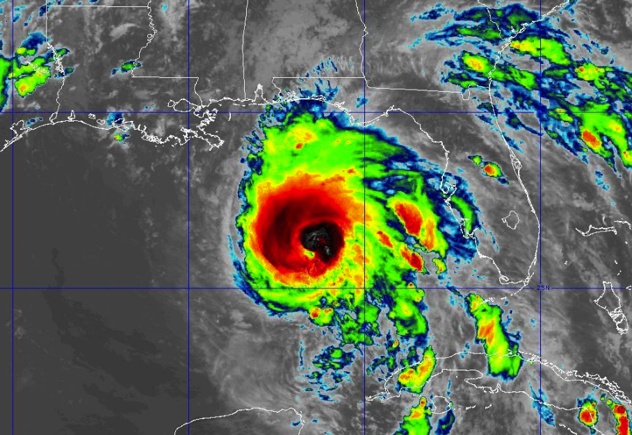
As of the latest update from the National Hurricane Center, maximum sustained winds are at 120 MPH, making it a major hurricane at category 3. Movement is still to the north at 12 MPH. The minimum central pressure is at 957mb. The eye is currently located around 295 miles south of Panama City, Florida, and around 270 miles south-southwest of Apalachicola, Florida.
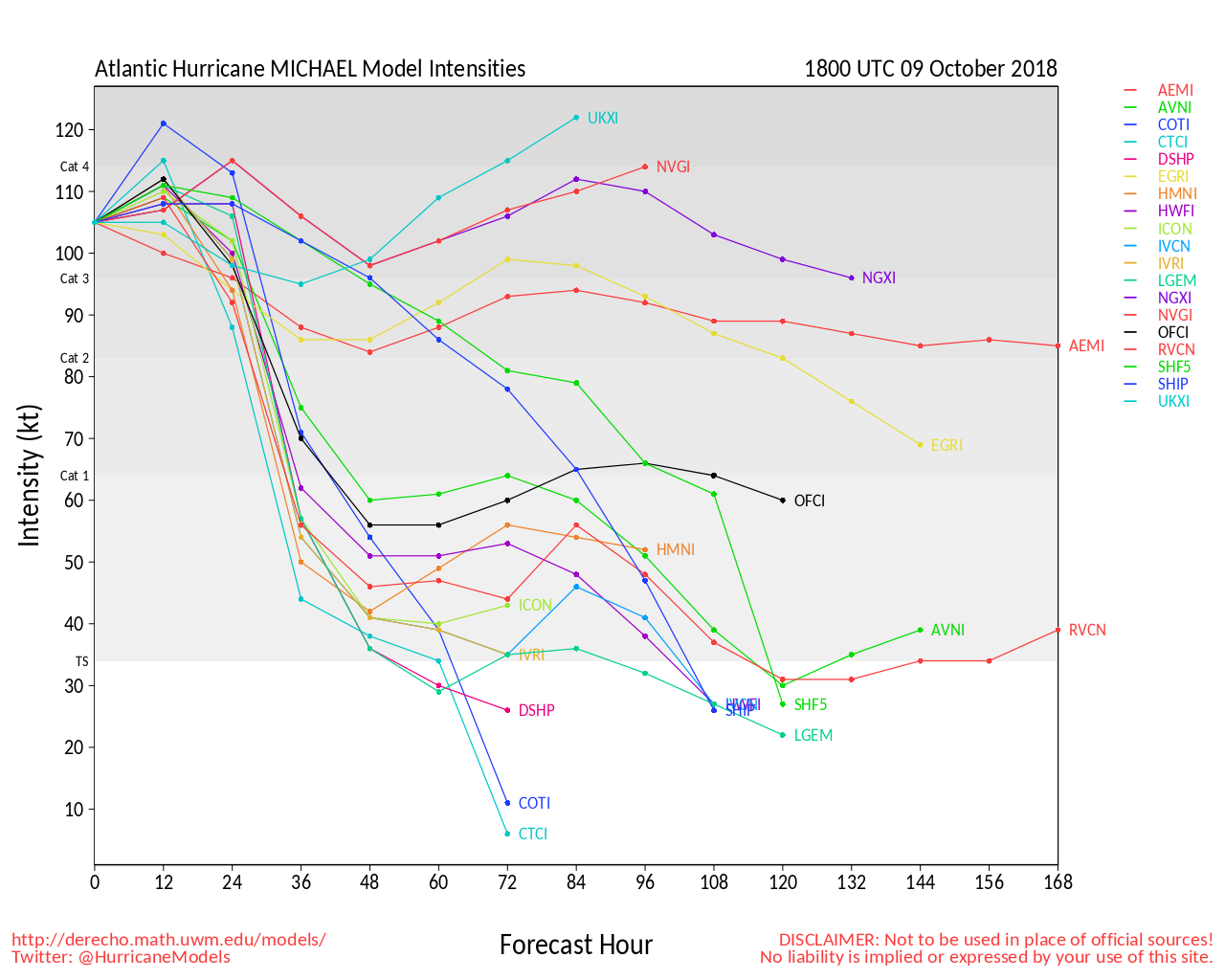
Looking at the Atlantic Hurricane Model Intensities for Michael, every member has it as a category 3 storm, with 3 of the members quickly ramping it up to a category 4 storm within the next 12-24 hours before making landfall, while the rest keep it as a category 3 storm until landfall.
The National Hurricane Center currently has Michael forecast to be a major hurricane as it makes landfall on the coast of the Florida Panhandle, with the eye crossing on shore somewhere from Mexico Beach to Apalachicola.
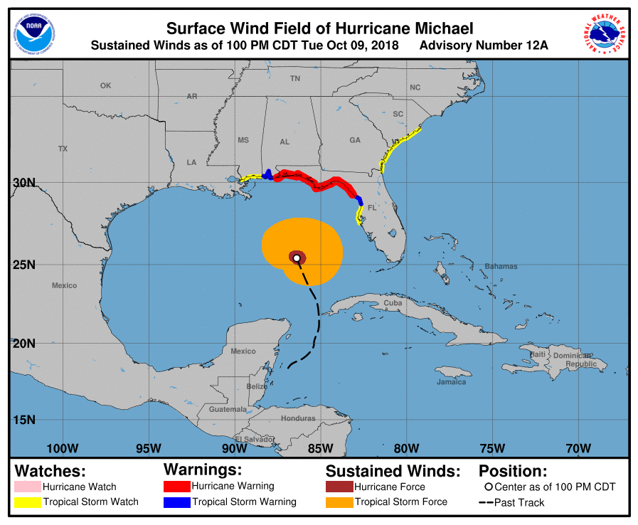
A Tropical Storm Warning has been issued from the Ferdinandina Beach, Florida, to the South Santee River in South Carolina. A Tropical Storm Watch has been issued from South Santee River in South Carolina to Duck, North Carolina.
The forecast continues to be on track for Central Alabama that we have been posting all day today. Much of the area will see scattered to numerous showers through the day on Wednesday, but rainfall totals will be less than 1/2 inch for much of the area.
The southeastern parts of the area, mainly along and south of the I-85 corridor, will be the only parts of the area that could see rainfall amounts in the 2-5 inch range and the possibility of winds in the tropical-storm-force range. The rest of Central Alabama should see wind gusts of 25 MPH or less throughout the day on Wednesday and into Wednesday evening. A Flash Flood Watch goes into effect tomorrow morning for Barbour, Bullock, Pike, and Russell counties. A Tropical Storm Watch is in effect for Pike and Barbour counties until further notice.
UPDATED SCHOOL CLOSINGS
Baldwin County
• Baldwin County Schools – closed Wednesday
Barbour County
• Barbour County Schools- closed Wednesday
• Eufaula City Schools- closed Wednesday
Coffee County
• Coffee County Schools – Tuesday’s after school activities canceled, closed Wednesday
• Enterprise City Schools – closed Wednesday, Tuesday’s after school activities canceled
• Elba City Schools- Tuesday’s after school activities canceled, closed Wednesday
Conecuh County
• Conecuh County Schools – closed Wednesday.
Covington County
• Andalusia City Schools – closed Wednesday
• Opp City Schools- closed Wednesday
• Covington County Schools- closed Wednesday
Crenshaw County
• Crenshaw County Schools – Tuesday after school activities canceled, closed Wednesday
Escambia County
• Escambia County Schools – closed Wednesday
• Brewton City Schools – closed Wednesday
Geneva County
• Geneva County Schools – on Fall break
Henry County
• Henry County Schools – closed Wednesday
Houston County
• Dothan City Schools – closing at 1 p.m. Tuesday. Closed Wednesday.
• Houston County Schools – closed all week for Fall break
• Wallace Community College, Dothan campus – closing at noon Tuesday. Closed Wednesday.
• Providence Christian School and First Presbyterian Preschool and Childcare – closed Wednesday
Pike County
• Pike County Schools – closed Wednesday
Category: Alabama's Weather, ALL POSTS, Tropical
About the Author (Author Profile)
Scott Martin is an operational meteorologist, professional graphic artist, musician, husband, and father. Not only is Scott a member of the National Weather Association, but he is also the Central Alabama Chapter of the NWA president. Scott is also the co-founder of Racecast Weather, which provides forecasts for many racing series across the USA. He also supplies forecasts for the BassMaster Elite Series events including the BassMaster Classic.Subscribe
If you enjoyed this article, subscribe to receive more just like it.


