Michael To Make Landfall Tomorrow; Main Impact Far Southeast Alabama
THIS AFTERNOON: As expected, we have high clouds over Alabama this afternoon along with a few widely scattered showers. Nothing widespread; temperatures are mostly in the low to mid 80s. We will maintain the chance of a few showers tonight.
Showers are more likely over the northern two-thirds of Alabama tomorrow as Hurricane Michael makes landfall, but it won’t rain all day, and most places will see rain amounts of 1/2 inch or less. Winds will stay under 20 mph over North and Central Alabama; impact from Micheal will be fairly minimal. The big issues will come across Southeast Alabama.
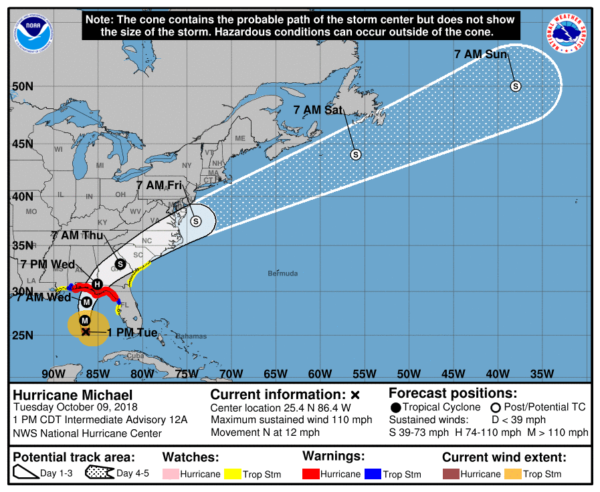
THE LATEST ON HURRICANE MICHAEL: The storm is now a dangerous, category three hurricane packing sustained winds of 120 mph.
*A Hurricane Warning is in effect from the Alabama/Florida border to Suwannee River Florida. The warning includes Geneva and Houston counties in Southeast Alabama. Hurricane conditions are expected within the hurricane warning area along the U.S. Gulf Coast tomorrow, with tropical storm conditions expected by tonight or early tomorrow. Hurricane conditions will also spread well inland across portions of the Florida Panhandle, southeastern Alabama and southwestern Georgia.
*Landfall is expected to be near Panama City Beach tomorrow at category three strength; the main storm surge damage will be from PCB eastward.. around to places like Mexico Beach, Port St. Joe, Cape San Blas, Indian Pass, Apalachicola, St. George Island, Carrabelle… and eastward through the “Big Bend” region.
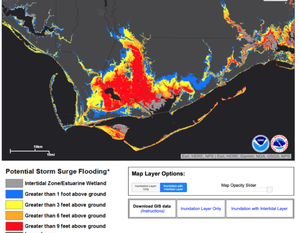
*A Storm Surge Warning is in effect from the Okaloosa/Walton County Line Florida to Anclote River Florida. The combination of a dangerous storm surge and the tide will cause normally dry areas near the coast to be flooded by rising waters moving inland from the shoreline. The water has the potential to reach the following heights above ground if peak surge occurs at the time of high tide…
Mexico Beach FL to Keaton Beach FL…9-13 ft
Okaloosa/Walton County Line FL to Mexico Beach FL…6-9 ft
Keaton Beach FL to Cedar Key FL…6-9 ft
Cedar Key FL to Chassahowitzka FL…4-6 ft
Chassahowitzka to Anna Maria Island FL including Tampa Bay…2-4 ft
Alabama/Florida border to Okaloosa/Walton County Line FL…2-4 ft
*The Alabama Gulf Coast, Mobile, Pensacola, and Navarre Beach will be on the “good” west side of the circulation with an offshore flow. Winds could gust there to 45 mph, and rain should be under 2 inches. No risk of tornadoes, most likely not enough rain for flash flooding.
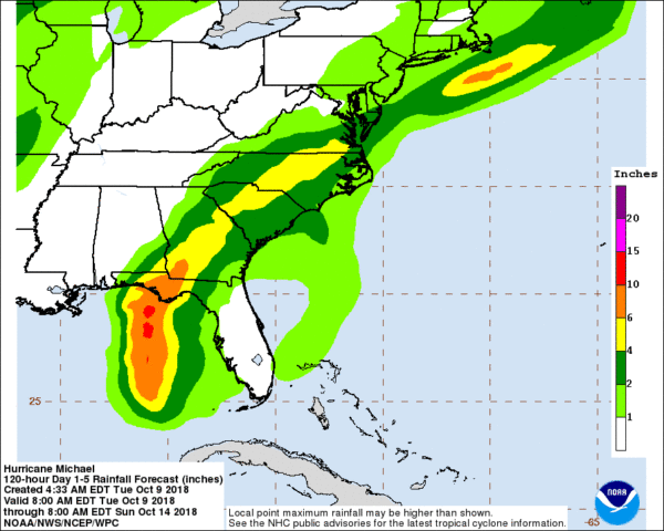
*A flash flood watch is in effect for much of North Florida, Southeast Alabama, and South Georgia. Michael is expected to produce the following rainfall amounts through Friday…
Florida Panhandle and Big Bend, southeast Alabama, and southern Georgia…4 to 8 inches, with isolated maximum amounts of 12 inches. This rainfall could lead to life threatening flash floods.
Eastern Georgia, the Carolinas, and southern Virginia…3 to 6 inches. This rainfall could lead to life-threatening flash floods.
*A few tornadoes are possible tomorrow and tomorrow night over North Florida and South Georgia.
*Double red flags are flying on the Gulf Coast; the water is closed due to rip currents.
*Michael will move along quickly, and weather conditions will improve on the Gulf Coast by early Thursday. Sunshine returns Thursday, and the weather looks very nice Friday through Sunday with sunny pleasant days and fair cool nights. Prefect weather for the National Shrimp Festival in Gulf Shores.
SOUTHEAST ALABAMA: Winds could gust to hurricane force over Geneva and Houston counties late tomorrow and tomorrow night, with potential for downed trees and power lines. Rain amounts of 3-5 inches are likely with potential for flash flooding. Winds could gust to 40 mph (tropical storm force) as far north as Greenville, Troy, and Eufaula.
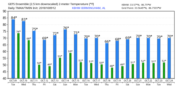
THURSDAY THROUGH THE WEEKEND: The sky clears across Alabama Thursday… any lingering showers over East Alabama will end early in the day. And, finally, much cooler air arrives with a high in the 70s. Look for low in the 46-49 degree range early Friday morning, the coolest temperatures so far this season. Then, the weather looks very nice Friday through the weekend with sunny pleasant days and clear cool nights. The high Friday and Saturday will be in the low 70s, followed by upper 70s Sunday. A few showers could reach the state Sunday night ahead of another cold front.
NEXT WEEK: We will mention a risk of showers Monday as the front passes through, but moisture will be very limited, and rain amounts will be light. More cool, dry air flows into the state during the middle of the week… see the Weather Xtreme video for maps, graphics, and more details.
RACE WEEKEND AT TALLADEGA: The weather looks fantastic Friday through Sunday with sunny days and fair nights. Highs in the 70s, lows in the 40s and 50s. A few showers could arrive Sunday night well after the big race has ended.
BEACH FORECAST: Click here to see the AlabamaWx Beach Forecast Center page.
WEATHER BRAINS: Don’t forget you can listen to our weekly 90 minute show anytime on your favorite podcast app. This is the show all about weather featuring many familiar voices, including our meteorologists here at ABC 33/40.
CONNECT: You can find me on all of the major social networks…
Facebook
Twitter
Instagram
Pinterest
Snapchat: spannwx
Look for the next Weather Xtreme video here by 7:00 a.m. tomorrow…
Category: Alabama's Weather, ALL POSTS, Tropical, Weather Xtreme Videos
About the Author (Author Profile)
James Spann is one of the most recognized and trusted television meteorologists in the industry. He holds the AMS CCM designation and television seals from the AMS and NWA. He is a past winner of the Broadcast Meteorologist of the Year from both professional organizations.Subscribe
If you enjoyed this article, subscribe to receive more just like it.


