6 a.m. NHC Update: Pressure Even Lower, Northeasterly Turn May Be Starting
The Air Force WC-130 plane just observed a pressure of 934.3 millibars. That could be 933 millibars when t is adjusted.
Hurricane Michael continues to strengthen and top winds will likely even be higher than the current 140 mph when the new advisory comes out before 7 a.m.
The fix shows a definite wobble to the right, which may be the expected northeasterly turn. If it is the turn, it places the center righto n the official forecast track, which would bring the center near or just southeast of Panama City.
The eye os Michael is clearly visible on coastal radars:
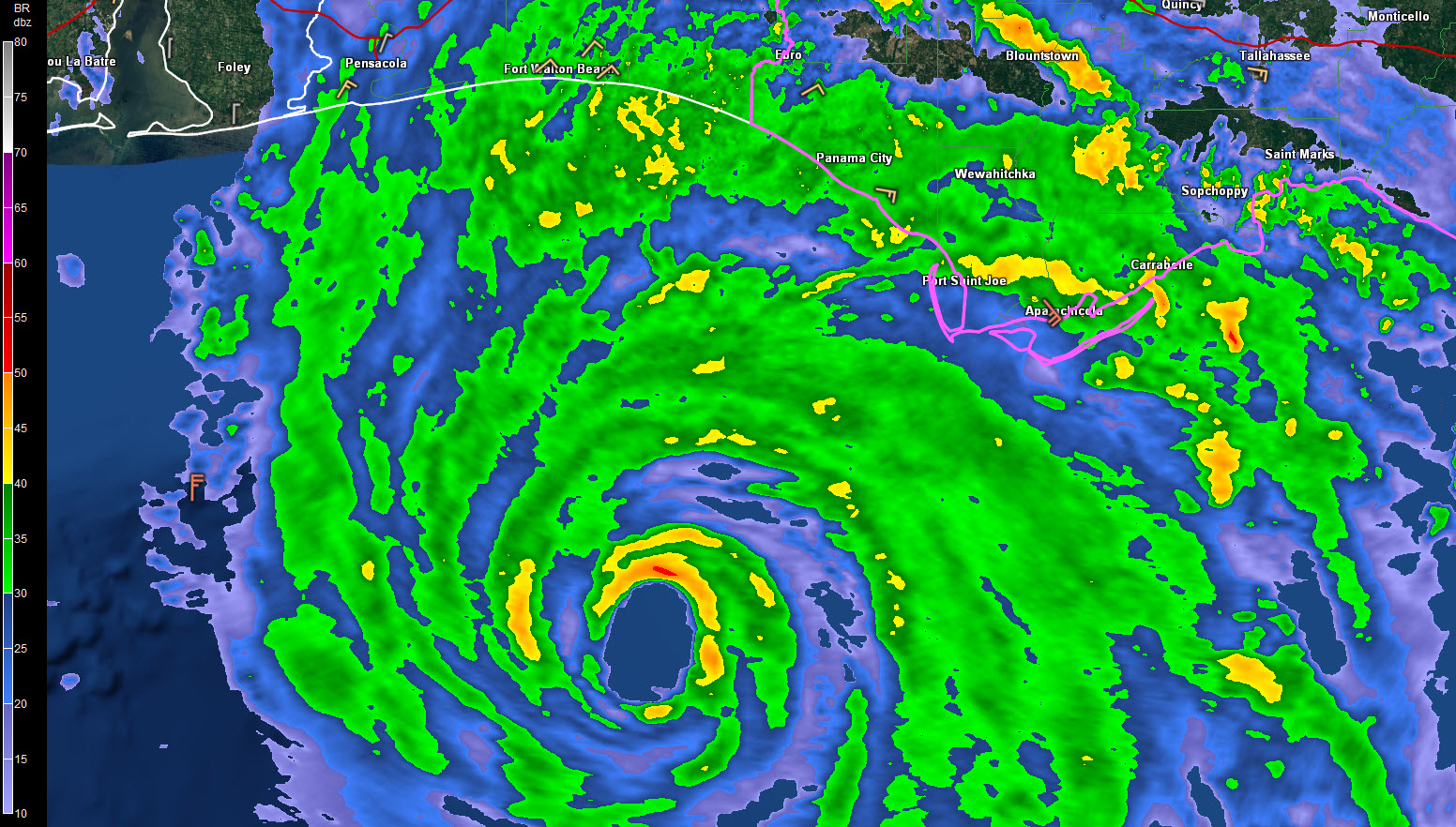
Hurricane Michael Tropical Cyclone Update
NWS National Hurricane Center Miami FL AL142018
600 AM CDT Wed Oct 10 2018
…6 AM CDT POSITION UPDATE…
…TROPICAL-STORM-FORCE WINDS SPREADING ONSHORE OF THE COAST OF THE
FLORIDA PANHANDLE…
NOAA buoy 42039, located about 90 miles (145 km) south-southwest
of Panama City, Florida, recently reported sustained winds
of 60 mph (97 km/h) and a wind gust of 76 mph (122 km/h). A wind
gust to 54 mph (87 km/h) was recently reported at Apalachicola
Regional Airport.
SUMMARY OF 600 AM CDT…1100 UTC…INFORMATION
———————————————–
LOCATION…28.8N 86.3W
ABOUT 105 MI…165 KM SSW OF PANAMA CITY FLORIDA
ABOUT 100 MI…160 KM SW OF APALACHICOLA FLORIDA
MAXIMUM SUSTAINED WINDS…140 MPH…220 KM/H
PRESENT MOVEMENT…N OR 5 DEGREES AT 13 MPH…20 KM/H
MINIMUM CENTRAL PRESSURE…937 MB…27.67 INCHES
$$
Forecaster Brown
About the Author (Author Profile)
Bill Murray is the President of The Weather Factory. He is the site's official weather historian and a weekend forecaster. He also anchors the site's severe weather coverage. Bill Murray is the proud holder of National Weather Association Digital Seal #0001 @wxhistorianSubscribe
If you enjoyed this article, subscribe to receive more just like it.


