Michael Nearing Landfall; Cooler Days Ahead
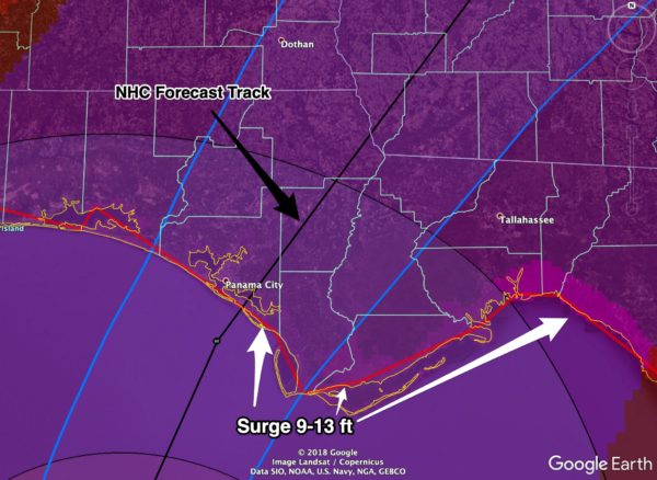
MICHAEL NOW A CATEGORY FOUR HURRICANE: Overnight Michael strengthened into an extremely dangerous, life threatening category four hurricane in the Gulf of Mexico with sustained winds of 145 mph. Landfall comes around midday today near Panama City Beach.
*A Hurricane Warning is in effect from the Alabama/Florida border to Suwannee River Florida. Hurricane conditions are expected within the hurricane warning area along the U.S. Gulf Coast today, with tropical storm
conditions expected to begin during the next few hours. Hurricane conditions will also spread well inland across portions of the Florida Panhandle, southeastern Alabama and southwestern Georgia.
We note the hurricane warning includes four counties in Southeast Alabama… Houston, Geneva, Dale, and Henry. Winds could gust to over 70 mph in these four counties this afternoon and tonight.
*A Tropical Storm Warning is in effect for Southeast Alabama, as far north as Evergreen, Greenville, Luvurne, Troy, and Phenix City. Winds in these areas could gust to 40-50 mph at times late this afternoon and tonight.
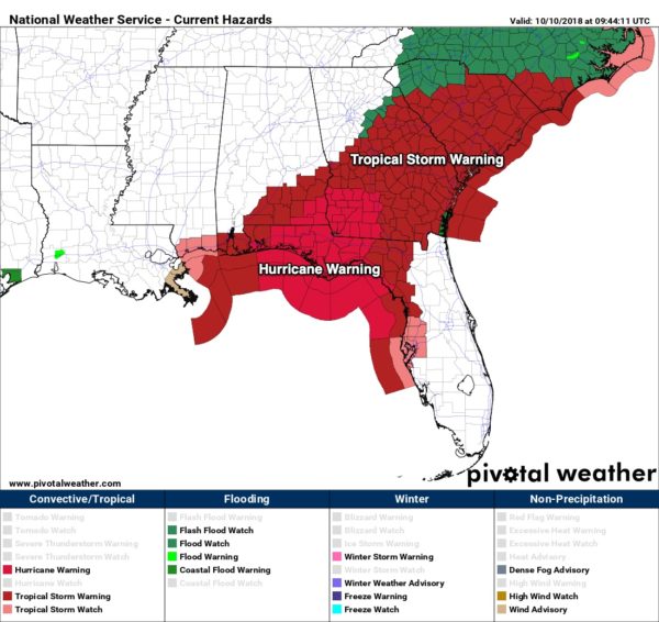
*A Storm Surge Warning is in effect from the Okaloosa/Walton County Line to Anclote River Florida. The combination of a dangerous storm surge and the tide will cause normally dry areas near the coast to be flooded by rising waters moving inland from the shoreline. The water has the potential to reach the following heights above ground if peak surge occurs at the time of high tide…
Tyndall Air Force Base FL to Keaton Beach FL…9-13 ft
Okaloosa/Walton County Line FL to Tyndall Air Force Base FL…6-9 ft
Keaton Beach FL to Cedar Key FL…6-9 ft
Cedar Key FL to Chassahowitzka FL…4-6 ft
Chassahowitzka to Anna Maria Island FL including Tampa Bay…2-4 ft
*The Alabama Gulf Coast, Mobile, and Pensacola will be on the “good”, west side of the system. Rain amounts under 2 inches, no tornado threat, no storm surge flooding due to the offshore flow.
*Rain amounts of 5 inches are possible across the southeast tip of Alabama today with some flooding potential; thankfully Michael will be moving along at a good clip… the hurricane will not stall like Florence.
*A few tornadoes are possible later today and tonight across North Florida and South Georgia, on the right side of the circulation of Michael.
*Sunshine returns to the Gulf Coast tomorrow, and the weather will be perfect for the National Shrimp Festival in Gulf Shores this weekend with sunny pleasant days and fair cool nights.
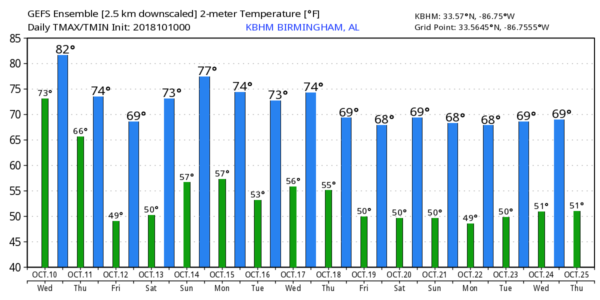
IMPACT FOR NORTH/CENTRAL ALABAMA: Michael will have little impact for the northern half of Alabama. Occasional, light showers are likely today… most communities will see rain amounts 1/2 inch or less. No risk of severe storms, and winds will be under 20 mph.
COOL CHANGE: Sunshine returns tomorrow, and a north wind of 10-20 mph will usher in the coolest air so far this season; the high will be in the 70s. Then, by Friday morning, we expect a low in the mid to upper 40s over the northern half of the state. Friday, Saturday, and Sunday will feature delightful fall weather with sunny pleasant days and clear cool nights. The high Saturday will be in the low 70s… Sunday will be a bit warmer with an afternoon high not too far from 80. Perfect weather for race weekend at Talladega.
NEXT WEEK: A few showers are possible Sunday night or Monday with a cold front, but moisture will be very limited and rain amounts very light. More cool air rolls in for the first half of the week… see the Weather Xtreme video for maps, graphics, and more details.
BEACH FORECAST: Click here to see the AlabamaWx Beach Forecast Center page.
WEATHER BRAINS: Don’t forget you can listen to our weekly 90 minute show anytime on your favorite podcast app. This is the show all about weather featuring many familiar voices, including our meteorologists here at ABC 33/40.
CONNECT: You can find me on all of the major social networks…
Facebook
Twitter
Instagram
Pinterest
Snapchat: spannwx
I have a weather program today at East Elementary in Cullman… keep an eye on the blog for frequent updates throughout the day!
Category: Alabama's Weather, ALL POSTS, Tropical, Weather Xtreme Videos
About the Author (Author Profile)
James Spann is one of the most recognized and trusted television meteorologists in the industry. He holds the AMS CCM designation and television seals from the AMS and NWA. He is a past winner of the Broadcast Meteorologist of the Year from both professional organizations.Subscribe
If you enjoyed this article, subscribe to receive more just like it.


