Rain Returns Later This Week
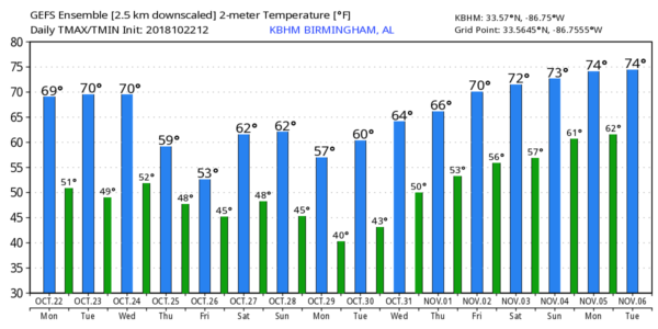
FINE FALL DAY: With ample sunshine, temperatures are mostly in the upper 60s and low 70s across the northern half of Alabama this afternoon. We see a few high cirrus clouds over South Alabama, but the low levels remain very dry. Tonight will be fair and cool, but not as cold as last night, with lows in the 40s for most places. Some of the traditionally colder spots could visit the 30s again.
TOMORROW/WEDNESDAY: Dry weather continues across Alabama with mostly sunny days and fair nights; highs will be in the low 70s, and lows in the 40s. Clouds move in Wednesday night ahead of a developing low on the Louisiana coast.
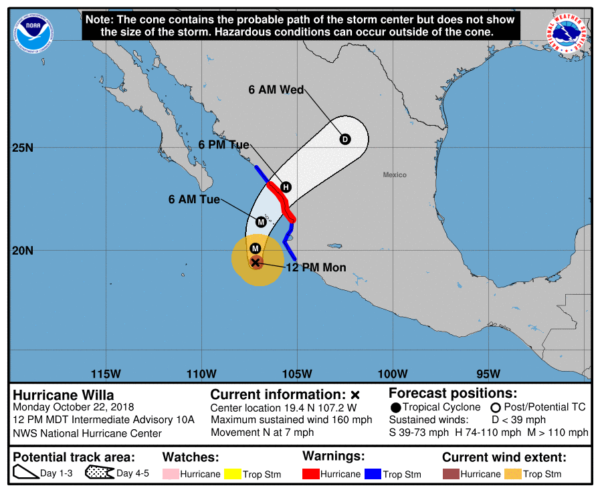
THURSDAY/FRIDAY: That surface low will move along the Gulf Coast; it partially the product of upper air wave energy now associated with Hurricane Willa in the eastern Pacific. This feature will set the stage for cloudy, cool, and wet weather for Alabama and the Deep South. Our main 24 hour window for rain will come from roughly 12 noon Thursday through 12 noon Friday. During that time we expect periods of rain, with amounts in the 1/2 to 1 range. Heavier totals will most likely come over the southern half of the state. The high Thursday will be close to 60, and we will hover in the low to mid 50s all day Friday… that is about 20 degrees below average for late October in Alabama.
The rain should be out of here in time for the high school football games Saturday night.
THE ALABAMA WEEKEND: We are forecasting partly sunny days, and mostly fair nights over the weekend with highs in the 60s and lows in the 40s. An upper trough will pass overhead Saturday night and Sunday, but for now it looks like the air will be too dry for any meaningful precipitation.
MAGIC CITY CLASSIC: For Saturday’s big game at Legion Field (Alabama State vs Alabama A&M… 2:30p CT kickoff), the sky should be partly sunny with temperatures in the 60s.
NEXT WEEK: The first half of the week looks dry with highs in the 60s and lows in the 40s… a weather system will have the potential to bring some rain toward the end of the week, but for now Halloween looks cool and dry on Wednesday. See the Weather Xtreme video for maps, graphics, and more details.
TROPICS: The Atlantic basin remains quiet, but over in the eastern Pacific Hurricane Willa reached category five status this morning with sustained winds of 160 mph. It should weaken by the time it reaches the coast of Mexico tomorrow, but it will still remain a major, dangerous hurricane. The system weakens rapidly over land, but moisture will move up into South Texas by Wednesday.
BEACH FORECAST: Click here to see the AlabamaWx Beach Forecast Center page.
WEATHER BRAINS: Don’t forget you can listen to our weekly 90 minute show anytime on your favorite podcast app. This is the show all about weather featuring many familiar voices, including our meteorologists here at ABC 33/40.
CONNECT: You can find me on all of the major social networks…
Facebook
Twitter
Instagram
Pinterest
Snapchat: spannwx
I had a great time today visiting with the students at Iola Roberts Elementary in Pell City… and Friday I had a fun trip to Odenville Elementary… be looking for them on the Pepsi KIDCAM today at 5:00 and 6:00 on ABC 33/40 News! The next Weather Xtreme video will be posted here by 7:00 a.m. tomorrow…
Category: Alabama's Weather, ALL POSTS, Weather Xtreme Videos
About the Author (Author Profile)
James Spann is one of the most recognized and trusted television meteorologists in the industry. He holds the AMS CCM designation and television seals from the AMS and NWA. He is a past winner of the Broadcast Meteorologist of the Year from both professional organizations.Subscribe
If you enjoyed this article, subscribe to receive more just like it.


