

Clouds Linger Today; A Mostly Dry Weekend Ahead
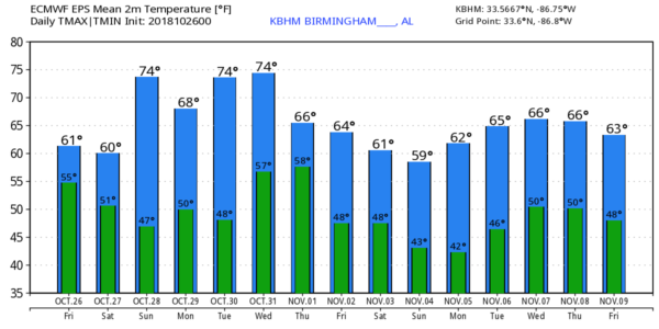
RADAR CHECK: Rain is still falling over parts of East Alabama early this morning, but the rain has ended over the western two-thirds of the state. And, that lingering rain should be out of the state soon. But, clouds will linger today, and temperatures remain below average for late October with a low only in the low 60s in most places (the average high for today in Birmingham is 72).
THE ALABAMA WEEKEND: The sky will stay cloudy tomorrow, although we could see some clearing by mid to late afternoon. We will still mention a few isolated showers in the forecast for the afternoon hours thanks to an upper trough overhead, but most places will be dry. The high tomorrow will be in the low 60s. Then, Sunday will be brighter and warmer… with a good supply of sunshine temperatures rise into the mid 70s. A cold front will pass through Sunday night, but it looks like the air will be too dry for any significant risk of showers.
FOOTBALL WEATHER: For the high school games tonight, the weather will be dry and cool.. the sky will be cloudy with temperatures falling in the 50s for the games.
For tomorrow’s Magic City Classic in Birmingham (Alabama State vs Alabama A&M at Legion Field; 2:30p CT kickoff), the sky will be mostly cloudy with just a slight risk of a shower during the game. In fact, the sun could break out a times. Temperatures will be in the low 60s at kickoff, but they will fall into the upper 50s by the final whistle.
Alabama and Auburn have a bye week; UAB is on the road; they take on UTEP in El Paso, Texas Saturday evening (6:30p CT kickoff)… the sky will be clear with temperatures falling from the low 70s at kickoff to near 60 by the end of the game.
NEXT WEEK: The weather will be dry Monday and Tuesday with chilly mornings but pleasant afternoons; the high Monday will be in the upper 60s, followed by mid 70s Tuesday. Wednesday will be mild and dry with a high well up in the 70s; clouds move in Wednesday night, and rain and storms are likely after midnight and into Thursday. There will be some surface based instability, and a few strong storms are possible. This looks like a good rain event with totals around one inch for most places. Drier air returns Friday. See the Weather Xtreme video for maps, graphics, and more details.
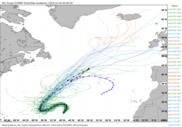
TROPICS: A disturbance in the Central Atlantic is expected to become Tropical Storm Oscar the weekend; it will drift westward before turning northeast out to sea… no threat to North America. The rest of the Atlantic basin is quiet.
BEACH FORECAST: Click here to see the AlabamaWx Beach Forecast Center page.
WEATHER BRAINS: Don’t forget you can listen to our weekly 90 minute show anytime on your favorite podcast app. This is the show all about weather featuring many familiar voices, including our meteorologists here at ABC 33/40.
CONNECT: You can find me on all of the major social networks…
Facebook
Twitter
Instagram
Pinterest
Snapchat: spannwx
I have a weather program this morning at Lupton Junior High School in Walker County… look for the next Weather Xtreme video here by 4:00 this afternoon. Enjoy the day!
Category: Alabama's Weather, ALL POSTS, Weather Xtreme Videos
About the Author (Author Profile)
James Spann is one of the most recognized and trusted television meteorologists in the industry. He holds the AMS CCM designation and television seals from the AMS and NWA. He is a past winner of the Broadcast Meteorologist of the Year from both professional organizations.Subscribe
If you enjoyed this article, subscribe to receive more just like it.


