Mostly Dry Weekend Ahead; Brighter/Warmer Sunday
CLOUDS HANGING TOUGH: Most of Alabama remains under a cloudy sky this afternoon, although the far southern counties are enjoying some sun. Temperatures remain well below average for late October; most North Alabama communities are in the 50s. Tonight will be dry, but overcast for most of the state.
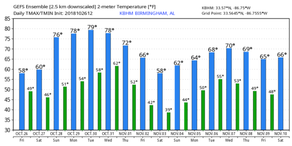
THE WEEKEND: Clouds will stay in place tomorrow morning, but the sun could begin to break through tomorrow afternoon as sinking air motion on the back side of an upper trough kicks in. You might see a few small, isolated showers, but most of Alabama will remain dry with a high around 60. Sunday will be brighter and warmer with sunshine in full supply… afternoon temperatures will rise into the mid 70s. A cold front will pass through Sunday night, but with little moisture we don’t expect any rain.
FOOTBALL WEATHER: For the high school games tonight, the weather will be dry and cool.. the sky will be cloudy with temperatures falling in the 50s for the games.
For tomorrow’s Magic City Classic in Birmingham (Alabama State vs Alabama A&M at Legion Field; 2:30p CT kickoff), the sky will be mostly cloudy with just a slight risk of a shower during the game. In fact, the sun could break out a times. Temperatures will be in the low 60s at kickoff, but they will fall into the upper 50s by the final whistle.
Alabama and Auburn have a bye week; UAB is on the road; they take on UTEP in El Paso, Texas Saturday evening (6:30p CT kickoff)… the sky will be clear with temperatures falling from the low 70s at kickoff to near 60 by the end of the game.
NEXT WEEK: The weather stays dry Monday and Tuesday with a good supply of sunshine both days; the high Monday will be in the mid 70s, followed by upper 70s Tuesday. For now Wednesday looks dry with a partly sunny sky along with a high between 77 and 80 degrees, but rain and storms return Thursday with a rather dynamic weather system approaching from the west; this one will have sufficient instability and dynamic support for strong thunderstorms… see the Weather Xtreme video for maps, graphics, and more details.
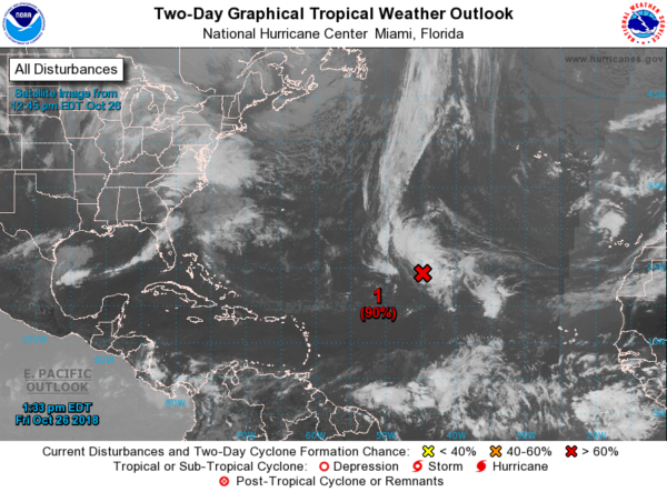
TROPICS: A high chance (90 percent) the disturbance in the Central Atlantic becomes a tropical or subtropical storm over the weekend (the name will be Oscar)… it will drift to the west, and then be carried out to the North Atlantic by an upper trough. It should remain far from land. The rest of the Atlantic basin is quiet.
BEACH FORECAST: Click here to see the AlabamaWx Beach Forecast Center page.
WEATHER BRAINS: Don’t forget you can listen to our weekly 90 minute show anytime on your favorite podcast app. This is the show all about weather featuring many familiar voices, including our meteorologists here at ABC 33/40.
CONNECT: You can find me on all of the major social networks…
Facebook
Twitter
Instagram
Pinterest
Snapchat: spannwx
I had a great time today visiting with the second graders at Lupton Junior High in Walker County… be looking for them on the Pepsi KIDCAM today at 5:00 on ABC 33/40 News! My next Weather Xtreme video will be posted here Monday morning by 7:00… enjoy the weekend!
Category: Alabama's Weather, ALL POSTS, Weather Xtreme Videos
About the Author (Author Profile)
James Spann is one of the most recognized and trusted television meteorologists in the industry. He holds the AMS CCM designation and television seals from the AMS and NWA. He is a past winner of the Broadcast Meteorologist of the Year from both professional organizations.Subscribe
If you enjoyed this article, subscribe to receive more just like it.


