Rain This Morning; Much Cooler Tomorrow
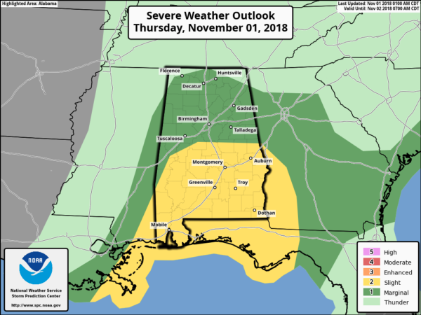
STORMY MORNING: A band of heavy showers continues to push into Alabama this morning; it will sweep rapidly through the state over the next few hours. There is little to no surface based instability over the northern half of Alabama, but there is a fairly high amount of directional shear. NWS has issued a tornado watch for roughly the western half of Alabama…
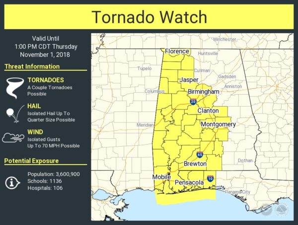
One or two short lived, isolated tornadoes are possible, but the overall severe weather risk is quite low for North Alabama due to the lack of instability. There is no lightning associated with the showers early this morning, and winds will be generally in the 20-30 mph range as they pass through, well below classic severe limits. Basically for most across North Alabama just a rainy morning.
There is a higher severe weather threat for South Alabama, where better instability is found. Storms there could produce strong, potential damaging winds.
Most of the heavier rain will be east of Alabama, into Georgia, by early afternoon. Clouds linger this afternoon and tonight, with a few lingering showers possible.
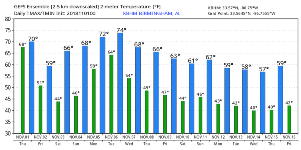
MUCH COOLER TOMORROW: Temperatures won’t get out of the 50s across North Alabama tomorrow with lingering clouds; some places near the Tennessee border could hold in the 40s all day. The sky will clear late in the day as drier air works in from the west.
THE ALABAMA WEEKEND: Saturday morning will be cold; we drop into the 38-42 degree range, and colder pockets across North Alabama could see some frost. Otherwise, we are forecasting a beautiful weekend with sunny days and fair nights. The high Saturday will be in the upper 60s, followed by low 70s Sunday.
FOOTBALL WEATHER: Great weather for the high school games across the state tomorrow night; look for a clearing sky with temperatures falling from the mid 50s at kickoff, into the 40s by the fourth quarter.
Auburn will host Texas A&M Saturday (11:00a CT kickoff) at Jordan-Hare Stadium… the sky will be sunny with temperatures rising from near 64 degrees at kickoff, into the upper 60s by the second half.
Alabama is on the road to take on LSU in Baton Rouge Saturday night (7:00p CT kickoff)… it will be a perfect night for football with a clear sky and temperatures falling through the 60s.
UAB will host UTSA at Legion Field in Birmingham Saturday evening (6:30 CT kickoff)… the sky will be clear with low 60s at kickoff, and mid 50s by the fourth quarter.
NEXT WEEK: More unsettled weather for Alabama early in the week, at some point we could be dealing with more strong storms (possibly severe), but model consistency in details is not good. Most likely the core threat will come on Tuesday, but showers are certainly possible Monday as well. The latter half of the week will be dry and cooler… see the Weather Xtreme video for maps, graphics, and more details.
TROPICS: Former Hurricane Oscar is now a post-tropical system in the North Atlantic… the rest of the Atlantic basin is quiet.
BEACH FORECAST: Click here to see the AlabamaWx Beach Forecast Center page.
WEATHER BRAINS: Don’t forget you can listen to our weekly 90 minute show anytime on your favorite podcast app. This is the show all about weather featuring many familiar voices, including our meteorologists here at ABC 33/40.
CONNECT: You can find me on all of the major social networks…
Facebook
Twitter
Instagram
Pinterest
Snapchat: spannwx
Look for the next Weather Xtreme video here by 4:00 this afternoon… enjoy the day!
Category: Alabama's Weather, ALL POSTS, Weather Xtreme Videos
About the Author (Author Profile)
James Spann is one of the most recognized and trusted television meteorologists in the industry. He holds the AMS CCM designation and television seals from the AMS and NWA. He is a past winner of the Broadcast Meteorologist of the Year from both professional organizations.Subscribe
If you enjoyed this article, subscribe to receive more just like it.


