Calm For Now, But New Tornado Watch Coming Soon For Parts of North Alabama
Here is a look at the Alabama weather situation as of 9 p.m.:
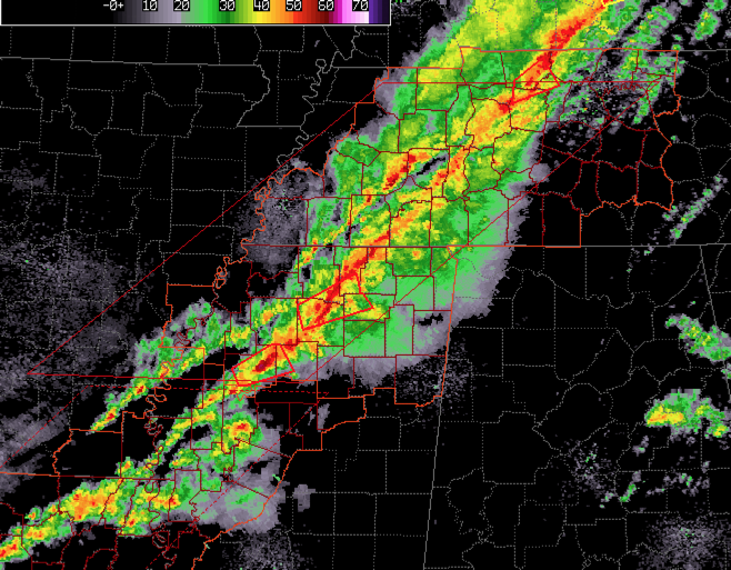
A dynamic storm system is bringing a severe weather threat to Alabama back through the Mid South tonight.
A iine of intense thunderstorms extends from southwestern Kentucky through western Tennessee and into northwestern Mississippi tonight. The storms extend from well west of Nashville to near Holly Springs and Batesville in Mississippi. The storms extend further back into northern Louisiana.
There is a tornado warning currently in effect for northern Mississippi around new Albany and Abbeville. Another tornado warning has just been issued for areas just to the southwest toward Batesville. Another tornado warned storm is about to cross I-55 north of Grenada.
A tornado watch continues until 3 a.m. for Central Tennessee and northern Mississippi. Another watch continues for northeastern Louisiana western Mississippi until 11 p.m.
A new watch is coming shortly for North Alabama. NWS Offices have already coordinate with the SPC.
For now across Alabama, things are still fairly calm. Showers are straddling I-20 west of Oxford. This cell is close to being able to produce lightning. It is likely along the surface warm front. Surface-based instability is around 500 joules/KG, which is modest.
The warm front appears to be lying from Huntsville to Birmingham to Roanoke. South of the boundary, dew points are greater than or equal to 65F. That moisture is important for severe weather. Surface-based instabilities will continue to increase during the overnight hours, with CAPE values approaching 1,000-1,500 joules across the northern half Alabama, with some values pushing 2,000 joules over Central Alabama.
Right now, there is a tremendous amount of shear over the northern half of Alabama, with 0-1 km helicity values approaching 300 m2/s2 over the northern half of Alabama. Bulk shear values are really high, with an 850 mb (about 5,000 feet above the ground) wind max moving over western Tennessee and southwestern Kentucky. Some of these working their way to the ground across northern Mississippi, northern Alabama and Tennessee. Winds have been consistently gusting to over 30 mph at Nashville for several hours.
There is plenty of lift with an approaching cold front as well.
There could be damaging winds and embedded tornadoes within the line of storms as it moves into Alabama later tonight. The timing looks like this:
Northwest Corner of Alabama: 11 p.m.
Hamilton: 2:30-3:30 a.m.
Jasper: 3:30-4:30 a.m.
Birmingham and Tuscaloosa: 4:00-5:00 a.m.
Gadsden: 5:30-6:30 a.m.
The good news is that the upper-level dynamics will be diminishing in coming hours as the wind max and disturbance lifts out to the northeast. But as the line arrives in the northwestern part of Alabama, there will be sufficient shear to overcome the limited instability and brief strong updrafts could tap the really strong winds aloft to produce tornadoes. Damaging winds will be likely as well.
Damaging winds and isolated tornadoes will be possible in the line of storms until about the time it gets to I-59, including places like Gadsden, Birmingham and Tuscaloosa. The threat will continue to diminish after the line crosses I-59.
Stay tuned to AlabamaWX throughout the night. We will have frequent weather updates throughout the night and the latest watches and warnings as they occur.
Make sure you have a reliable way to receive warnings all night, even while sleeping. Have a place to go if you are in a mobile home in case a warning is issued. You don’t want to be caught on the highway though, as cars are death traps in a tornado.
Category: Alabama's Weather, ALL POSTS, Severe Weather
About the Author (Author Profile)
Bill Murray is the President of The Weather Factory. He is the site's official weather historian and a weekend forecaster. He also anchors the site's severe weather coverage. Bill Murray is the proud holder of National Weather Association Digital Seal #0001 @wxhistorianSubscribe
If you enjoyed this article, subscribe to receive more just like it.


