Becoming Sunny Today; Rain Returns Late Friday
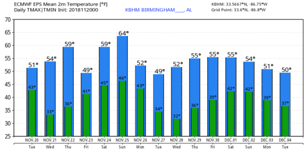
CLEARING THIS MORNING: We have a few a lingering sprinkles on radar early this morning in the wake of a cold front that passed through a few hours ago; those will end soon and the sky will clear this morning. Everyone will be in bright sunshine by afternoon, and temperatures will be cooler today with highs generally in the 50s. Tonight will be clear and cold; we will be very close to freezing early tomorrow morning.
TOMORROW/THANKSGIVING: Dry weather continues tomorrow and Thursday with sunny days and clear nights; the high tomorrow will be in the mid to upper 50s, and on Thanksgiving Day we rise into the low 60s.
FRIDAY THROUGH THE WEEKEND: Clouds will return Friday, and rain should arrive late in the day as a wave aloft approaches from the west. Rain will be widespread statewide Friday night with a few thunderstorms possible. Severe storms are not expected, and rain amounts of 1/2 to 1 inch are likely. The rain should end very early in the day Saturday, possibly before daybreak, we might see a few peeks of sun Saturday afternoon with a high in the mid 60s.
Clouds thicken again Sunday, and showers are likely Sunday afternoon and evening ahead of another cold front. This will be a fairly dynamic system, but moisture and instability will be lacking. The high Sunday will also be in the mid 60s.
FOOTBALL WEATHER: For the high school playoff games Friday night, rain is likely with temperatures in the 50s. Then, for the Iron Bowl Saturday in Tuscaloosa (Auburn at Alabama… 2:30p CT kickoff)… the sky will be mostly cloudy, but the weather looks dry. Temperatures will be in the mid 60s at kickoff, falling back into the upper 50s by the final whistle.
UAB plays at Middle Tennessee State Saturday (2:00p CT kickoff in Murfreesboro)… the sky will be mostly cloudy, but no rain is expected. Temperatures will be in the low 60s at kickoff, falling into the 50s by the second half.
NEXT WEEK: Monday will be breezy and cooler with clouds lingering much of the day, then we expect dry and chilly weather on Tuesday and Wednesday. More rain is possible late in the week… see the Weather Xtreme video for maps, graphics, and more details.
ON THIS DATE IN 1900: A tornado struck the town of Columbia, in Maury County, Tennessee, at approximately 9:30 PM CST. A very destructive and devastating path was cut through the northwestern parts of town, with the most damage occurring in the Macedonia community. This twister ended up being rated a F4, and was on the ground for a total of 8 miles. The damage path at its widest was 300 yards, littered with pieces of homes and cabins. 27 people lost their lives, and another 75 were injured.
BEACH FORECAST: Click here to see the AlabamaWx Beach Forecast Center page.
WEATHER BRAINS: Don’t forget you can listen to our weekly 90 minute show anytime on your favorite podcast app. This is the show all about weather featuring many familiar voices, including our meteorologists here at ABC 33/40.
CONNECT: You can find me on all of the major social networks…
Facebook
Twitter
Instagram
Pinterest
Snapchat: spannwx
I have weather programs today at Coldwater Elementary in Calhoun County… and Vestavia Hills Cahaba Heights Elementary. Look for the next Weather Xtreme video here by 4:00 this afternoon… enjoy the day!
Category: Alabama's Weather, ALL POSTS, Weather Xtreme Videos
About the Author (Author Profile)
James Spann is one of the most recognized and trusted television meteorologists in the industry. He holds the AMS CCM designation and television seals from the AMS and NWA. He is a past winner of the Broadcast Meteorologist of the Year from both professional organizations.Subscribe
If you enjoyed this article, subscribe to receive more just like it.


