Models Still Show The Potential For Strong To Severe Storms On Saturday Afternoon
The latest high-resolution models continue to show some differences on the 00z runs, but some aspects are coming into a better agreement at this time. We continue to see a conditional threat of severe storms during the afternoon and into the early evening hours across a good portion of Central Alabama as conditions will be conducive. We are still seeing that there is the possibility of the air over the area to become stable after the morning round of storms due to rain-cooled air and some cloud cover.
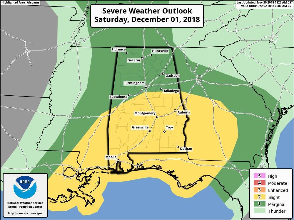
At this point, the Storm Prediction Center continues to have the southern half of Alabama in the standard Slight Risk (level 2 of 5) of severe storms throughout the day on Saturday, with the northern half of the state defined in a Marginal Risk (level 1 of 5). The latest Hazardous Weather Outlook from NWS Birmingham states that there is a low threat for strong to marginally severe storms Saturday from 12:00 pm through 6:00 pm. If storms are able to redevelop after morning rain, there could be a risk of a brief tornado and hail up to one inch in diameter (quarter size). Confidence remains low in the forecast at this time.
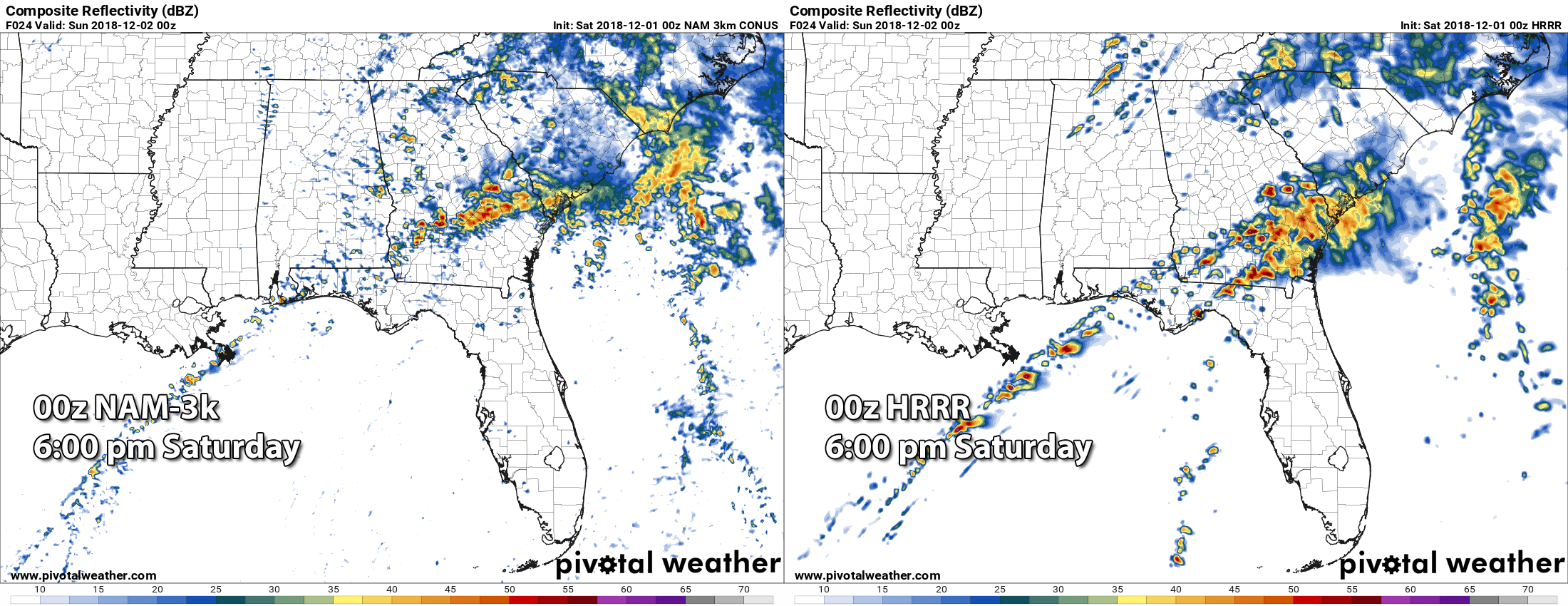
Where the high-resolution models (NAM and HRRR) agree at this point is the amount of shear that will be possible throughout Saturday afternoon, as the crossover winds from the surface will be backed out of the south-southeast and quickly veering out of the southwest at the 5,000 feet level. Those models also agree somewhat on the lack of redevelopment of storms after the morning rain, even though the HRRR does show a little development around 6:00 PM over the northern counties of the state.
Where these models differ are in the location and values of the instability and the significant tornado parameter. At 6:00 pm Saturday, STP values of 1.0 to 3.0 can be seen on the NAM confined to the southwestern parts of Central Alabama, while the HRRR has values up to 4.2 across a good portion of the central and south-central parts of Central Alabama. Nearly the same setup on instability as CAPE values of 1,000 to 2,200 J/kg on the NAM is confined to the southwestern parts of Central Alabama, while the HRRR paints the same range in values over the central and south-central parts of Central Alabama.
So we are still expecting a round of rain and a few thunderstorms during the morning hours on Saturday from 6:00 am to 12:00 pm. Some of these could become strong, but the likelihood of severe weather is very low at this point. The better thermodynamics move into the area during the afternoon and into the early evening hours where the potential is there for storms to develop that could be strong to severe. The big questions are… Will there be enough time for the atmosphere to recover from the morning rain?… Will there be enough sunshine during the afternoon that will allow for the atmosphere to become more unstable?… and… Will the cap continue to win out the battle and keep the instability contained at the surface?
We’re almost at the point where we’ll just have to wait and see what happens. Please, to be on the safe side, go ahead and have you severe weather action plan ready to go and have your supplies ready in your safe place, just in case a warning is issued for your location. While this doesn’t appear to be a big severe weather outbreak, all it takes is one storm to make it a big deal for you. Have fresh batteries in your NOAA WeatherRadio and in your flashlights, and have your smartphones fully charged. Be sure to download the ABC 33/40 app on your smartphone so you can watch live severe weather coverage from your safe place if you are in a warning.
We’ll have updates throughout Saturday on the AlabamaWx Weather Blog. Check back often.
Category: Alabama's Weather, ALL POSTS
About the Author (Author Profile)
Scott Martin is an operational meteorologist, professional graphic artist, musician, husband, and father. Not only is Scott a member of the National Weather Association, but he is also the Central Alabama Chapter of the NWA president. Scott is also the co-founder of Racecast Weather, which provides forecasts for many racing series across the USA. He also supplies forecasts for the BassMaster Elite Series events including the BassMaster Classic.Subscribe
If you enjoyed this article, subscribe to receive more just like it.


