Potential For Strong To Severe Storms This Afternoon Across Central Alabama
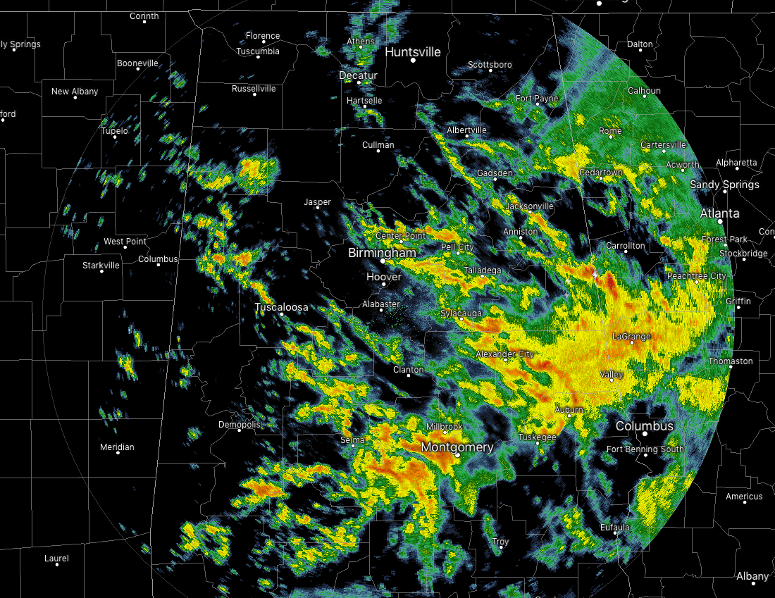
Radar at 7:15 AM shows much of the rain activity has moved well into the eastern half of the state, while the coverage is more scattered in nature in the western half. Temperatures are in the mid-50s to the lower 60s across Central Alabama at this point, with the warm spots being Troy, Montgomery, and Tuscaloosa at 61 degrees. Birmingham was at 57 degrees.
TODAY: We have a tricky forecast for today as conditions would support the development of strong to severe thunderstorms during the afternoon and into the early evening hours, but that is conditional on how much can the atmosphere recover from this morning’s storms.
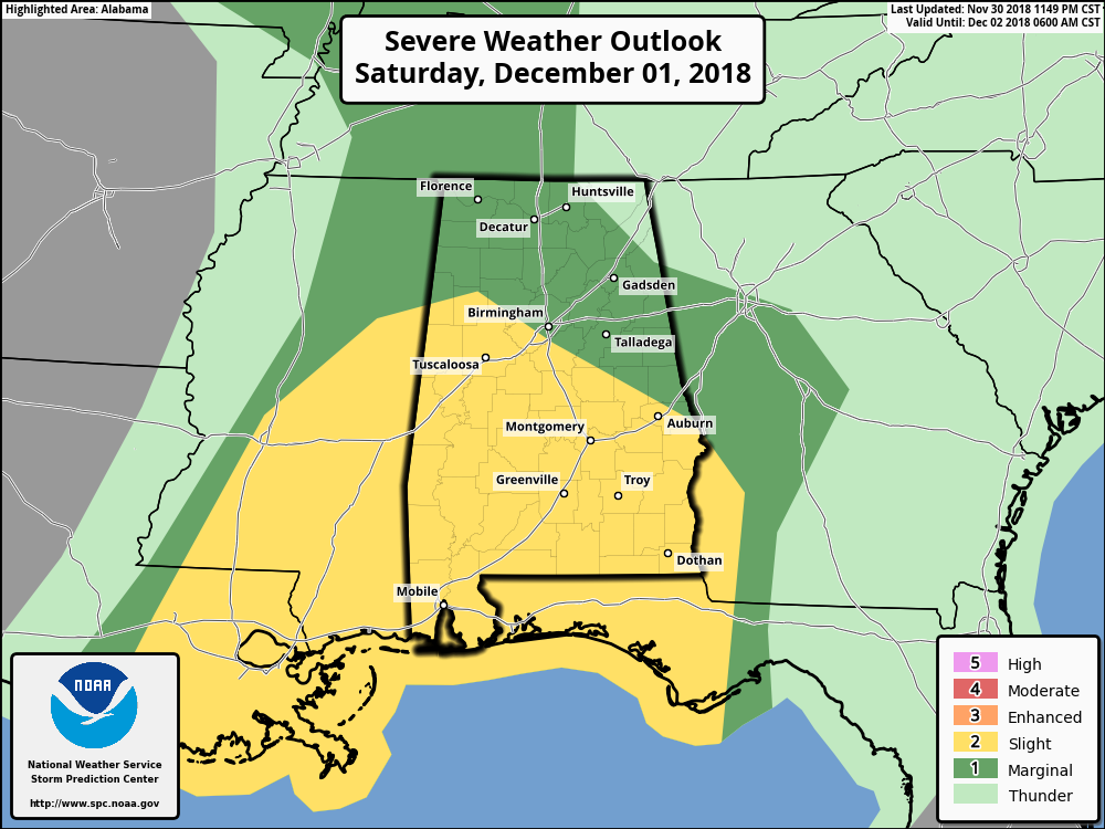
The Storm Prediction Center continues to have much of Central Alabama in the standard Slight Risk of severe storms for today, while the extreme northern parts of the area continue in a Marginal Risk.
The 06z run of the NAM this morning shows that the instability doesn’t really move into the area until after 3:00 pm and dropping as it moves throughout the area. Shear would be the strongest through 9:00 pm with surface winds backing out of the south-southeast then quickly veering to the southwest at 5,000 feet. Significant tornado parameter values start off in the 1.0-3.0 range at 3:00 pm and gradually lowers into the 1.0-2.0 range by midnight.
All of this shows that the ingredients are there for the development of severe storms as we’ll have high shear and a good bit of instability in place. Threats would be from damaging winds, some isolated hail up to quarter size, and one or two tornadoes. The only thing that will be lacking is the forcing to get the convection. The front doesn’t move through tonight until the late night and into the overnight hours, well behind when the atmosphere would be primed. Plus, the front will be weakening and starting to flatten out as it moves into the area.
So once the morning push of showers and storms move through this morning, we’ll have a chance of more showers and thunderstorms through the remainder of the day. Any storms that do form during the afternoon hours has the potential to become strong to severe. Afternoon highs will top out in the lower 60s to the mid-70s. Rain will come to an end later tonight and skies will begin a gradual clearing. Lows will get down into the lower 50s to the mid-60s.
SUNDAY: The weakened cold front has made its way through the area and will stall out to our south and southeast on Sunday, confining showers and storms to the Gulf Coast of Florida and over into Georgia. For us, we’ll have sunny skies and highs will be in the upper 60s to the mid-70s.
MONDAY: The front continues to be stalled out near the Gulf Coast on Monday, keeping the active weather southeast of us, while we will have an overall nice day with mostly sunny skies and highs in the upper 50s to the upper 60s.
TUESDAY: The stalled front finally gets kicked out of here on Tuesday and colder temperatures will start to move into the area. Skies will be partly to mostly cloudy with clearing occurring late in the day. Highs will range from the mid-40s to the upper 50s.
WEDNESDAY: High pressure is just off to our west and this will continue to reinforce the flow of cooler and dry continental air from the north. We’ll have plenty of sunshine on Wednesday with just a few clouds and highs in the lower 40s to the lower 50s.
THURSDAY: With higher pressure sitting over the top of Central Alabama on Thursday, we’ll continue to have dry weather. Skies will be partly cloudy with afternoon highs in the mid-40s to the lower 50s.
FRIDAY: While much of the day on Friday will be dry with mostly cloudy skies, a few scattered showers are possible during the evening and into the overnight hours as another system heads in our direction. Afternoon highs will be in the upper 40s to the upper 50s.
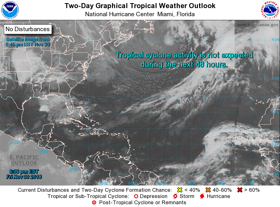
TROPICS: The Atlantic Hurricane Season ended very quietly as of Friday night at 11:59 pm. This will be the last update on the tropics until the start of the season on June 1st, unless we get an rogue off-season cyclone to develop.
Category: Alabama's Weather, ALL POSTS, Weather Xtreme Videos
About the Author (Author Profile)
Scott Martin is an operational meteorologist, professional graphic artist, musician, husband, and father. Not only is Scott a member of the National Weather Association, but he is also the Central Alabama Chapter of the NWA president. Scott is also the co-founder of Racecast Weather, which provides forecasts for many racing series across the USA. He also supplies forecasts for the BassMaster Elite Series events including the BassMaster Classic.Subscribe
If you enjoyed this article, subscribe to receive more just like it.


