Rain Rolls Into Alabama Friday Night; Wet Weekend Ahead
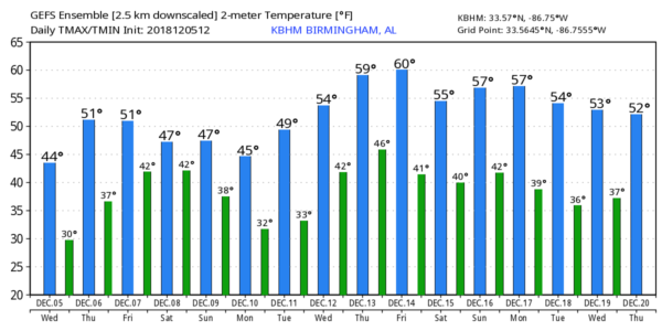
CLOUDLESS SKY: Despite sunshine in full supply, temperatures are well below average across Alabama this afternoon. In fact, Fort Payne and Albertville are at 37 degrees at 3:00… Cullman reports 40. We could typically be in the mid to upper 50s in early December, based on seasonal averages. Tonight will be clear and cold with another significant freeze; most communities across North/Central Alabama will be in the mid 20s early tomorrow. Some of the colder pockets could visit the upper teens.
Tomorrow will be partly to mostly sunny with a high close to 50 degrees. Then, on Friday, clouds roll into the state, and rain should arrive Friday night, spreading into the state from the west.
COLD, WET WEEKEND: A cold, soaking rain is likely Saturday as a surface low scoots eastward along the Gulf Coast. No severe storms, probably no thunder. Just an all-day kind of rain with temperatures holding in the 40s over North Alabama, with 50s to the south. The weather on Sunday won’t be much better; cloudy, cold, and wet with periods of light rain and drizzle.
SNOWFLAKES? As the surface low moves to the east, and colder air is pulled down into Alabama, there is some risk of light snow or snow flurries across the northeast part of the state Sunday night into Monday morning. Based on forecast thermal and moisture profiles, we aren’t expecting any impact at this point if we do see a snowflake or two. Of course, this is still five days away and things could change as the system gets closer.
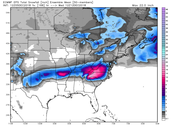
The significant snow from the weekend system will be north of Alabama, in a broad zone from the Texas Panhandle to Virginia and North Carolina. Some of the heaviest snow is expected to fall in the southern Appalachians.
REST OF NEXT WEEK: Tuesday and Wednesday look dry with a slow warming trend, then rain and possibly a few thunderstorms should arrive late Thursday and Thursday night ahead of a new system moving in from the west, followed by another shot of colder air. See the Weather Xtreme video for maps, graphics, and more details…
BEACH FORECAST: Click here to see the AlabamaWx Beach Forecast Center page.
WEATHER BRAINS: Don’t forget you can listen to our weekly 90 minute show anytime on your favorite podcast app. This is the show all about weather featuring many familiar voices, including our meteorologists here at ABC 33/40.
CONNECT: You can find me on all of the major social networks…
Facebook
Twitter
Instagram
Pinterest
Snapchat: spannwx
Look for the next Weather Xtreme video here by 7:00 a.m. tomorrow…
Category: Alabama's Weather, ALL POSTS, Weather Xtreme Videos
About the Author (Author Profile)
James Spann is one of the most recognized and trusted television meteorologists in the industry. He holds the AMS CCM designation and television seals from the AMS and NWA. He is a past winner of the Broadcast Meteorologist of the Year from both professional organizations.Subscribe
If you enjoyed this article, subscribe to receive more just like it.


