Clouds Move In Tonight; Cold, Wet Days Ahead
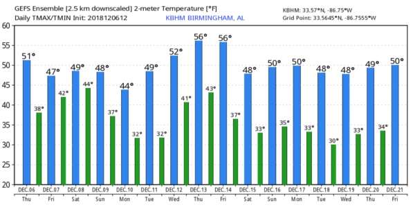
EXTENDED PERIOD OF WET WEATHER IS AHEAD: The sky is partly to mostly sunny this afternoon with temperatures around 50 degrees across North/Central Alabama… clouds will thicken tonight ahead of a weather system loaded with moisture. Tomorrow will be a cloudy and rather chilly day, and computer model guidance continues to speed up the arrival time of the rain. Rain should begin during the day tomorrow, then becoming widespread tomorrow night and Saturday as a surface low moves along the Gulf Coast.
We should mention that as the precipitation begins tomorrow morning, some sleet could be mixed in with the rain, especially over Northwest Alabama. Temperatures will be above freezing and we expect no impact if we do see any ice pellets.
The low will be well east of Alabama Sunday, but wrap around moisture means another cloudy, cold day with light rain and drizzle. For those of you over the northern half of Alabama, temperatures won’t get out of the 40s tomorrow through the weekend; South Alabama will see highs in the 50s.
It will be a cold, soaking rain for much of the state; amounts of 2-3 inches are likely. No worries with severe weather thanks to the stable in place. About the only chance of any thunder is near the Gulf Coast. This certainly won’t be a “Chamber of Commerce” weekend.
MONDAY: Monday will be another cloudy, cold day with highs in the 40s over North Alabama, with 50s to the south. Some drizzle is possible during the morning hours… a few snow flurries are possible over the northeast tip of the state. If we do see any flurries we expect no impact.
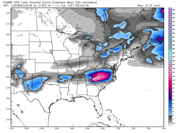
To see some real snow, try western North Carolina, or the southwest part of Virginia. This could be a huge snow event for them, with amounts over one foot in many places. Snow is likely in the mountains of East Tennessee late Sunday into Monday as well.
REST OF NEXT WEEK: Tuesday and Wednesday will be dry with a warming trend, then we will deal with a round of rain and thunderstorms by late Thursday and Friday.. the latest GFS run is suggesting some potential for strong thunderstorms. See the Weather Xtreme video for maps, graphics, and more details.
ON THIS DATE IN 1983: An early morning tornado tore through Selma. Path length = 13 mi. A total of 103 structures were damaged/destroyed along the path. 30+ vehicles at a new car dealership destroyed. A dorm at Selma University had significant damage. There was one fatality at an apartment complex.
BEACH FORECAST: Click here to see the AlabamaWx Beach Forecast Center page.
WEATHER BRAINS: Don’t forget you can listen to our weekly 90 minute show anytime on your favorite podcast app. This is the show all about weather featuring many familiar voices, including our meteorologists here at ABC 33/40.
CONNECT: You can find me on all of the major social networks…
Facebook
Twitter
Instagram
Pinterest
Snapchat: spannwx
I had a great time today seeing the 5th graders at Southside Elementary… be looking for them on the Pepsi KIDCAM today at 5:00 on ABC 33/40 News! Also a big thanks to everyone at Honda Manufacturing of Alabama for having me as the emcee of the 2019 Passport rollout today, and also to the senior adults at North Glencoe Baptist for a great visit as well. The next Weather Xtreme video will be posted here by 7:00 a.m. tomorrow…
Category: Alabama's Weather, ALL POSTS, Weather Xtreme Videos
About the Author (Author Profile)
James Spann is one of the most recognized and trusted television meteorologists in the industry. He holds the AMS CCM designation and television seals from the AMS and NWA. He is a past winner of the Broadcast Meteorologist of the Year from both professional organizations.Subscribe
If you enjoyed this article, subscribe to receive more just like it.


