Snowflakes Cause Excitement But No Problems For Alabama; Could Be Icy Spot or Two Tomorrow Morning Though
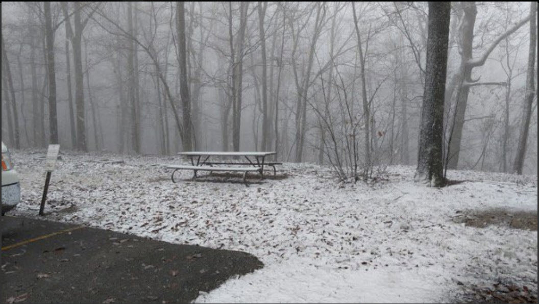
A fairly miserable day is in progress across North and Central Alabama with temperatures in the 36-42F range across North and Central Alabama, thick cloud cover and some light precipitation. Some of that precipitation is falling as a mix of light rain and snow. Check out this view from atop Monte Sano Mountain in Huntsville from Kevin Richmond:
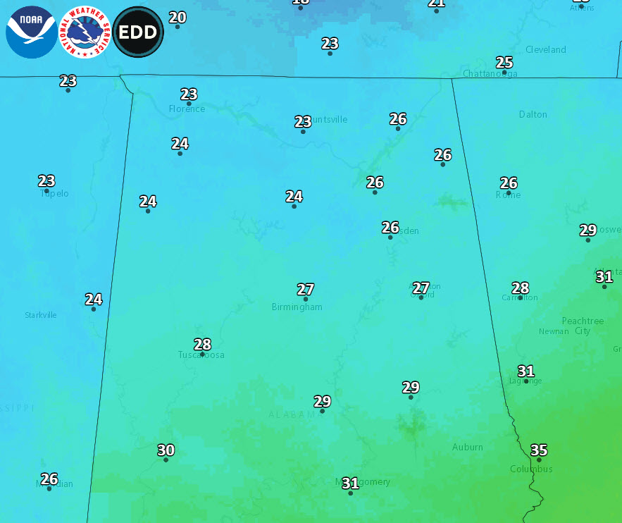
No travel problems are occurring though, with ground temperatures in the upper 30s to low 40s and air temperatures where they are. The precipitation area will slide to the south and east and wane as we go through the late afternoon hours with precipitation ending by mid-evening. Lows tonight will be cold, in the middle 20s across North Central Alabama, with upper 20s south of I-20. Here are official forecast lows for tomorrow morning:
PATCHY ICE IN THE MORNING THOUGH: The sky will clear late tonight, and we drop into the 20s by daybreak tomorrow. While the sky will be clear tomorrow morning, be aware any standing water left over from the big weekend rain event could turn into ice in spots.
TOMORROW/WEDNESDAY: These two days will be dry with a warming trend as high pressure builds in; the sky will be mostly sunny both days. The high tomorrow will be around 50, followed by mid to upper 50s on Wednesday.
NEXT WEATHERMAKER: Our next system will come in the form of another strong upper-level trough that will be moving out on to the Plains by Wednesday. Rain will arrive over western sections during the day on Thursday and increase overnight with around 1 to 1.5 inches of rain expected across the northern half of the state. There could be some thunder, with the surface near Memphis by Friday morning, but I wouldn’t count on it.
HEADING TO THE WEEKEND: Rain should diminish by midday Friday, and a slot of drier air could keep the state relatively dry Friday afternoon and Friday night, but we will still keep a chance of showers going. The high Friday will be in the mid 50s. We will keep a chance of showers in the forecast Saturday morning, but the rest of the weekend looks dry. Sunday should feature a good supply of sunshine as dry air settles into the state; the high both days will be in the 55-59 degree range.
NEXT WEEK: For now the week looks relatively quiet; generally dry with seasonal temperatures… highs mostly in the 50s. See the Weather Xtreme video for maps, graphics, and more details.
I CAN SEE CHRISTMAS: The GFS paints the picture that Alabama will be dry and seasonal for the holiday period. No real hope of a White Christmas. Our hopes dashed again!
BEACH FORECAST: Click here to see the AlabamaWx Beach Forecast Center page.
Category: Alabama's Weather, ALL POSTS
About the Author (Author Profile)
Bill Murray is the President of The Weather Factory. He is the site's official weather historian and a weekend forecaster. He also anchors the site's severe weather coverage. Bill Murray is the proud holder of National Weather Association Digital Seal #0001 @wxhistorianSubscribe
If you enjoyed this article, subscribe to receive more just like it.


