Weather Xtreme Video: A Few Pesky Showers Today Before Nice Weather Returns
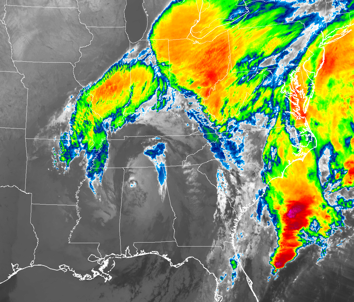
TODAY: While the center of low pressure will be slowly moving across the deep south today, we’ll be on the south side of the low which has been the drier side of the system for the past day. While we’ll continue to have a chance of showers for the much of the area north of the I-85 corridor, the activity will be scattered and light in nature. Rain chances throughout the daylight hours will range from 20% to just below 50% across the area from south to north. Highs will top out in the lower to mid-50s. For tonight and through the overnight hours, much of the activity will have moved out of the area, but I wouldn’t be surprised if one or two light showers or sprinkles linger around after sunset. After that, we’ll dry out with mostly cloudy skies. Overnight lows drop into the mid-30s to the lower 40s.
SUNDAY: The low finally moves out of the area and we get a chance to dry out for several days starting on Sunday. Skies will start off mostly cloudy, but slow clearing will occur and we’ll end up with partly cloudy skies by the late afternoon hours. Afternoon highs will be in the 50s across the area.
MONDAY: The start of the work week will be a great one across the area. We’ll have plenty of bright sunshine to brighten your Monday with only one or two passing clouds. Afternoon highs top out in the upper 50s to the lower 60s.
TUESDAY: A great weather day across Central Alabama as the closest organized precipitation to us will be up in the Pacific Northwest. We’ll have plenty of sunshine with just a few passing clouds and afternoon highs will be in the mid-50s to the lower 60s.
WEDNESDAY: Wednesday will be another nice day across Central Alabama. Skies will be mostly clear throughout the day, but clouds will start to move into the area from the west during the late afternoon and into the evening hours. No rain at this point as shower chances hold off until early Thursday. Afternoon highs will be in the upper 50s to the lower 60s.
THURSDAY: We’ll have a disturbance move into Central Alabama before sunrise on Thursday that will bring us our next shot at rain. Showers at this point look to be scattered in nature, but we’ll have a decent chance of rain throughout the entire day and well into the evening and late night hours. Rainfall amounts will be around 0.25 inches for the entire day and afternoon highs will top out in the mid-50s to the lower 60s.
FRIDAY: On Friday, the system lifts out of the area and moves up the Atlantic states as the low deepens. We’ll have some wrap-around precipitation on the backside of the low moving across the northern half of the area. During the morning and into the early afternoon hours. This run of the GFS is painting the possibility of some flurries or light snow showers at the end, but I am having a hard time believing that as daytime highs will be in the upper 40s to the mid-50s across the area.
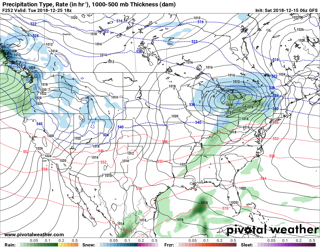
Valid on Christmas Day at noon.
VOODOO LAND: As we are now 10 days away from Christmas Day, we are getting closer to having a good idea on what to expect. Christmas Eve looks to be a nice day, but we may have to deal with a brief period of showers on the late morning through the afternoon hours on Christmas Day. Both days at this point look to be really cool with highs near 50 degrees and lows in the mid-30s.
BEACH FORECAST CENTER: Get the latest weather and rip current forecasts for the beaches from Fort Morgan to Panama City on our Beach Forecast Center page. There, you can select the forecast of the region that you are interested in.
WE’RE HAVING A RECORD-BREAKING YEAR… ADVERTISE WITH US TODAY!: Don’t miss out! We have enjoyed over 19.2 MILLION page views on AlabamaWx.com so far in 2018. We can customize a creative, flexible and affordable package that will suit your organization’s needs. Contact Bill Murray at (205) 687-0782.
E-FORECAST: Get the Alabama Wx Weather Blog’s Seven-Day Forecast delivered directly to your inbox by email twice daily. It is the most detailed weather forecast available in Central Alabama. Subscribe here… It’s free!
CONNECT ON SOCIAL MEDIA: You can find the AlabamaWx Weather Blog on the major social media networks:
Facebook
Twitter
WEATHERBRAINS: Don’t forget you can listen to our weekly 90 minute netcast anytime on the web at WeatherBrains.com or on iTunes, Stitcher, or Spotify. This is the show all about weather featuring many familiar voices, including the meteorologists at ABC 33/40.
ON THIS DAY IN WEATHER HISTORY: 2005 – Freezing rain and ice pellets fell throughout portions of the southeast U.S. The accumulation of ice caused about 683,000 utilities customers to lose power from northern Georgia northward through the western Carolinas. The power outages were the result of ice accretions of up to three-quarter inch in thickness. The ice storm was blamed for at least four deaths.
Category: Alabama's Weather, ALL POSTS, Weather Xtreme Videos
About the Author (Author Profile)
Scott Martin is an operational meteorologist, professional graphic artist, musician, husband, and father. Not only is Scott a member of the National Weather Association, but he is also the Central Alabama Chapter of the NWA president. Scott is also the co-founder of Racecast Weather, which provides forecasts for many racing series across the USA. He also supplies forecasts for the BassMaster Elite Series events including the BassMaster Classic.Subscribe
If you enjoyed this article, subscribe to receive more just like it.


