Some Sun Later Today; Big Time Cold Five Days Away
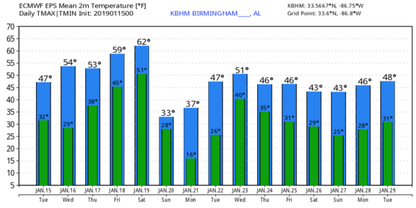
BRIGHTER THIS AFTERNOON: A layer of status has been very persistent across Alabama over the past few days, and they are still hanging over the state early this morning. But, subsidence should take over later today as the sky becomes partly sunny, and we project a high around 50 degrees this afternoon. Tonight will be clear and cold with a low near the freezing mark, and tomorrow will feature a partly to mostly sunny sky with a high in the mid to upper 50s.
THURSDAY/FRIDAY: A disturbance will bring clouds back into Alabama Thursday, and a few showers are likely Thursday afernoon and Thursday night. Moisture will be very limited with this feature, and rain amounts should be fairly light; the high Thursday will be in the upper 50s. Then, on Friday, the warming trend continues as temperatures rise into the 60s. A stray shower is possible Friday morning in spots, otherwise the day will be generally cloudy with only a limited amount of sun.
SATURDAY: Clouds thicken again as the weekend begins, and a dynamic weather system will bring rain to our state Saturday afternoon and into Saturday night. Some thunder is possible, but we don’t expect any issues with severe thunderstorms due to the lack of instability. The main window for rain comes from about noon until midnight, and rain amounts of 1/2 to 1 inch are likely. It will be a mild day with a high in the 60s.
COLDEST AIR SO FAR ARRIVES SUNDAY: Bitterly cold air rolls into Alabama Sunday with a strong north wind. Many communities north of Birmingham will stay below freezing all day, and the north wind of 15-30 mph will push the wind chill index into the single digits much of the day. A few snow flurries are possible after midnight Saturday night and Sunday morning as the Arctic air blasts into the state, but we expect no accumulation or impact. The cold air is the big story.
The sky will clear Sunday night, and by Monday morning we project a low in the 10-20 degree range for North/Central Alabama, easily the coldest morning so far this season. The day Monday will be sunny with a high in the low 40s.
TO THE NORTH: Another high impact snow event is likely this weekend in a broad zone from St. Louis and Chicago into the Northeast U.S. Too early to be specific on placement and amounts, but travelers beware.
REST OF NEXT WEEK: Tuesday will be dry with a high in the upper 40s, and then we will bring in a chance of some rain Wednesday afternoon or Wednesday night. The chance of rain will linger into Thursday, and possibly Friday. Thermal profiles suggest all liquid precipitation; there is no evidence of any significant snow or ice for Alabama for the next seven days, despite what you might read on Facebook, or what your “crap app” says. See the Weather Xtreme video for maps, graphics, and more details.
ON THIS DATE IN 1967: The Green Bay Packers beat the Kansas City Chiefs, 35-10, in Super Bowl I at the Memorial Coliseum in Los Angeles. From the weather station at the USC campus in downtown LA, the high temperature was 79 degrees and the low was 51. There was a light west wind.
BEACH FORECAST: Click here to see the AlabamaWx Beach Forecast Center page.
WEATHER BRAINS: Don’t forget you can listen to our weekly 90 minute show anytime on your favorite podcast app. This is the show all about weather featuring many familiar voices, including our meteorologists here at ABC 33/40.
CONNECT: You can find me on all of the major social networks…
Facebook
Twitter
Instagram
Pinterest
Snapchat: spannwx
I have a weather program this morning at Edgewood Elementary in Homewood… look for the next Weather Xtreme video here by 4:00 this afternoon… enjoy the day!
Category: Alabama's Weather, ALL POSTS, Weather Xtreme Videos
About the Author (Author Profile)
James Spann is one of the most recognized and trusted television meteorologists in the industry. He holds the AMS CCM designation and television seals from the AMS and NWA. He is a past winner of the Broadcast Meteorologist of the Year from both professional organizations.Subscribe
If you enjoyed this article, subscribe to receive more just like it.


