Clouds Return Tomorrow; Rain Wednesday
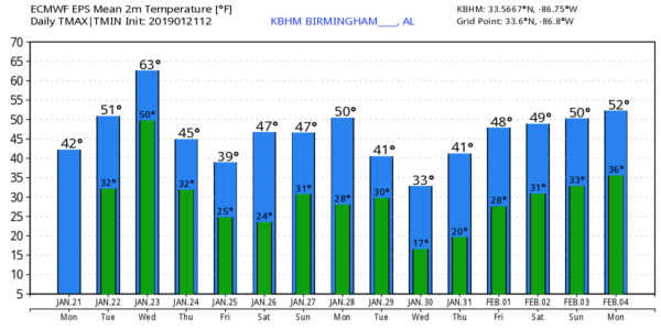
SUNNY BUT COLD: Despite sunshine in full supply, temperatures are only in the 30s and 40s over North Alabama this afternoon, with 50s across the southern counties. Tonight will be clear and cold, but not as cold as last night. Most places will see a low in the upper 20s early tomorrow morning.
RAIN RETURNS: Clouds move into the state tomorrow ahead of the next weather system to the west, and rain becomes widespread during the day Wednesday. The air will be stable, so there is no threat of severe storms, and probably little thunder. Rain amounts will be around 1/2 inch, with isolated heavier totals. Colder air begins to flow into the state late Wednesday night, and there is a chance a few snow flurries could develop from around midnight Wednesday night through daybreak Thursday, but for now we expect no accumulation or impact.
The sky becomes partly to mostly sunny Thursday with a high in the 40s. Dry, chilly weather continues on Friday with a partly sunny sky and highs mostly in the low to mid 40s.
THE ALABAMA WEEKEND: Saturday looks dry and a bit warmer with temperatures possibly edging up into the 50s thanks to a good supply of sunshine. An “Alberta Clipper” type system will bring some clouds into the state late Saturday night and Sunday, and it could squeeze out a little light rain. But new model guidance continues to trend drier, and we might even get away with dry conditions Sunday. The high Sunday will be in the 45-50 degree range with more clouds than sun.
NEXT WEEK: Monday will be dry, then another clipper type system will bring a chance of some light rain, or maybe a little light snow, Tuesday and Tuesday night. Much colder air will follow the clipper on Wednesday; looks like we won’t get out of the 30s with a brisk north wind.
We note there is no evidence at this point of any disruptive snow or ice event for Alabama over the next 7 days, although a few flurries are possible late Wednesday night. See the Weather Xtreme video for maps, graphics, and more details.
SATURDAY’S STORM REPORTS: NWS Birmingham identified 4 tornadoes this past Saturday. The most significant was an upper end EF-2 that moved through Wetumpka, in Elmore County, producing significant damage. That tornado was 18.2 miles long with maximum winds of 135 MPH… the maximum width was 700 yards. An EF-1 tornado touched down in Coosa County southeast of Rockford, and other EF-1 tornado damage paths were found in Dallas and Autauga counties.
BEACH FORECAST: Click here to see the AlabamaWx Beach Forecast Center page.
WEATHER BRAINS: Don’t forget you can listen to our weekly 90 minute show anytime on your favorite podcast app. This is the show all about weather featuring many familiar voices, including our meteorologists here at ABC 33/40.
CONNECT: You can find me on all of the major social networks…
Facebook
Twitter
Instagram
Pinterest
Snapchat: spannwx
Look for the next Weather Xtreme video here by 7:00 a.m. tomorrow…
Category: Alabama's Weather, ALL POSTS, Weather Xtreme Videos
About the Author (Author Profile)
James Spann is one of the most recognized and trusted television meteorologists in the industry. He holds the AMS CCM designation and television seals from the AMS and NWA. He is a past winner of the Broadcast Meteorologist of the Year from both professional organizations.Subscribe
If you enjoyed this article, subscribe to receive more just like it.


