

Wet/Windy Weather For Alabama Today
GOOD SOAKING AHEAD: Rain becomes widespread across the great state of Alabama today; we project rain amounts between 1 an 2 inches statewide between now and midnight. And, a few strong storms are possible over the southern counties of the state… SPC has defined a “slight risk” (level 2/5) of severe storms for parts of Mobile and Baldwin counties today, with a “marginal risk” (level 1/5) as far north as Demopolis, Greenville, and Geneva.
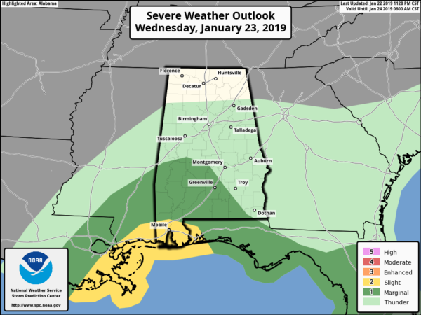
Storms over far South Alabama will have the potential to produce strong winds, and an isolated tornado or waterspout. The main window for the heavier storms there will come from roughly 12 noon until 6 p.m.
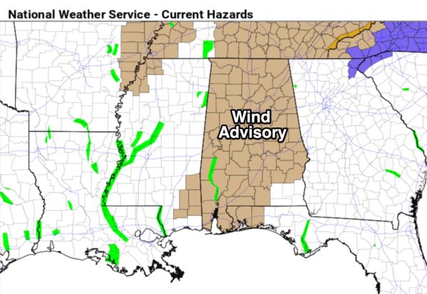
In addition, there is a wind advisory in effect today for all of Alabama, with the exception of the southeast corner of the state. Pressure gradient winds (not related to thunderstorms) out of the south will average 15 to 25 mph with higher gusts.
FLURRIES? The rain ends from west to east tonight, and as colder air rushes into the state, a few light flurries are possible over North Alabama, but there will be no impact or accumulation.
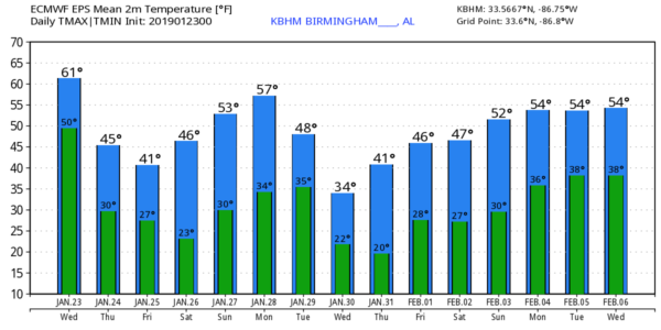
TOMORROW/FRIDAY: The weather both days will be cold and dry. The sky partly to mostly sunny; tomorrow’s high will be in the upper 40s, followed by low 40s Friday. A cold front should pass through in mostly dry fashion tomorrow night, although it might squeeze out a snow flake or two in spots. Again, no impact, and most places will be dry.
THE ALABAMA WEEKEND: Dry weather continues. Saturday morning will be cold with a low in the 20-25 degree range, but we rise into the mid 50s Saturday afternoon with a mostly sunny sky. Sunday will be partly sunny with high back in the mid 50s; a clipper type system to the north won’t impact the state with precipitation since the air will be so dry.
NEXT WEEK: Monday will be dry and pleasant with a high around 60, but an Arctic front will bring much colder air Tuesday, along with the chance of some light rain. A few flurries, or areas of light snow, are possible Tuesday in the colder air, but for now the chance of meaningful accumulation or impact looks small. Temperatures on Tuesday will likely fall into the 30s with a brisk north wind.
Wednesday will be cold and dry with a high only around 40 degrees; upper teens are possible Wednesday and Thursday morning. No precipitation Wednesday through Friday… see the Weather Xtreme video for maps, graphics, and more details.
ON THIS DATE IN 1969: An F4 tornado cut a 120-mile long path from Jefferson through Copiah, Simpson, Smith, Scott, and Newton Counties in Mississippi, killing 32 and injuring 241 others. Property damage was estimated at $2 million. An inbound Delta Airlines aircraft reported a hook echo on its scope with this storm.
BEACH FORECAST: Click here to see the AlabamaWx Beach Forecast Center page.
WEATHER BRAINS: Don’t forget you can listen to our weekly 90 minute show anytime on your favorite podcast app. This is the show all about weather featuring many familiar voices, including our meteorologists here at ABC 33/40.
CONNECT: You can find me on all of the major social networks…
Facebook
Twitter
Instagram
Pinterest
Snapchat: spannwx
I have a weather program this morning at Oscar Adams Elementary in Gadsden… look for the next Weather Xtreme video here by 4:00 this afternoon. Enjoy the day!
Category: Alabama's Weather, ALL POSTS, Weather Xtreme Videos
About the Author (Author Profile)
James Spann is one of the most recognized and trusted television meteorologists in the industry. He holds the AMS CCM designation and television seals from the AMS and NWA. He is a past winner of the Broadcast Meteorologist of the Year from both professional organizations.Subscribe
If you enjoyed this article, subscribe to receive more just like it.


