Rain Tonight; Snow Early Tomorrow; Sun By Afternoon
QUICK HITTING WINTER STORM AHEAD: Hard to believe snow flakes are possible across Alabama tomorrow if you take a walk outside this afternoon. Temperatures are in the low 60s in many places with a good supply of sunshine. It almost feels like spring. But all eyes are on the Arctic front, now entering far northern Arkansas. That front will race through Alabama early tomorrow morning.
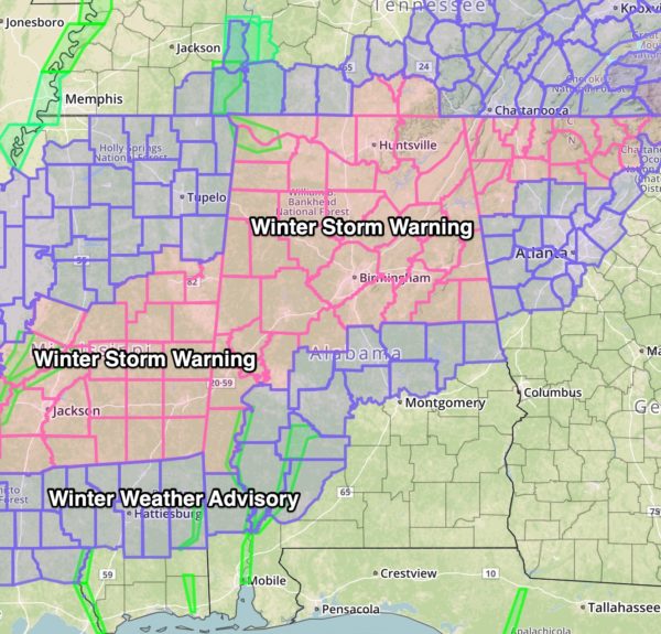
A winter storm warning remains in effect for roughly the northern half of Alabama (Bibb, Calhoun, Clay, Cleburne, Greene, Hale, Randolph, Shelby, Sumter, Talladega counties have been added to the Winter Storm Warning), and a winter weather advisory is in effect down to Jackson, Camden, Selma, Prattville, Wetumpka, and Lafayette.
TIMING: Rain will move into North Alabama tonight, and the change to snow begins over the northwest counties of the state from midnight to 2 a.m. The change to snow for places like Tuscaloosa, Birmingham, and Gadsden will come between 3:00 and 5:00 a.m… and for Anniston from 4:00 until 6:00 a.m.
The snow won’t last too long; generally 2 hours for most places. But the snow rates will be fairly high, giving us the chance of accumulating snow despite the warm soil temperatures after the sunny day today.
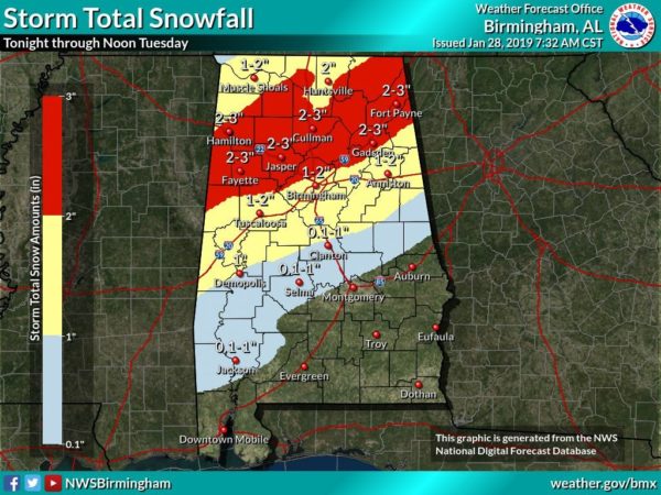
HOW MUCH: Snow amounts of 1-2″ are expected across the winter storm warning area, or areas along and north of I-59. Amounts of 1/2 to 1″ are possible across the winter weather advisory area across Central and Southwest Alabama. Our “boom” value is 4 inches at Birmingham; this is not expected, but we believe the maximum amount the system can generate. The “bust” value is 1/4″, or basically a dusting. The “boom” and “bust” values are just a way of communicating the inherent uncertainty that is a part of all winter weather forecasts.
ACCUMULATION AFTER A DAY IN THE LOW 60S??? High snow rates can always overcome warm soil temperatures. I have seen this many times in my career, and with heavier snow at 4, 5, and 6:00 a.m. it can indeed accumulate. The warmth today was expected.
IMPACT: I often point out that we aren’t road engineers; our training is in atmospheric science. So forecasting road conditions is a little out of our field of expertise. But, temperatures will go below freezing tomorrow morning as the snow falls, and travel certainly can be impacted. Initially with ice on bridges and overpasses, and if snow rates are heavy enough, some black top roads can become snow covered and dangerous. Icy travel could begin in the Birmingham metro as early as 5:00/6:00 a.m.
The sun will break out tomorrow afternoon, pushing temperatures into the 35-40 degree range. This will melt much of the snow, and allow for improvements on roads. There will also be a good bit of evaporation thanks to lowering dew points. But, if any moisture lingers, icy spots will redevelop tomorrow night into early Wednesday morning when temperatures fall through the 20s. The potential for icy travel tomorrow night and early Wednesday is very conditional.
If we do have icy travel early Wednesday morning, it won’t last long. The sun will be out in full force Wednesday and temperatures will rise above freezing by mid-morning.
POWER OUTAGES? No. There is no freezing rain involved with this system. It will be light rain changing to snow, and will be of short duration.
SCHOOLS: You can see the list of school closings tomorrow on the ABC 33/40 site here.
BUT MY APP SAYS NO SNOW??? Automated weather apps (most all of them are automated) are pretty much useless in this kind of situation. Always check with actual professional meteorologists who give you information like you are getting on this blog post. Timing, amount, uncertainty, etc. Apps use raw computer model data without any human intervention, and can lead you down a bad path.
REMEMBER: Not everyone in a winter storm warning will get a lot of snow. Some will get nothing at all. Snow never follows state and county lines like we show on accumulation maps, they are simply a guideline. And, the volume of social media posts about snow is not necessarily directly proportional to the amount of snow we’re actually going to get. It seems like the more people are talking about it, the worse it’s going to be, but that’s not always the case.
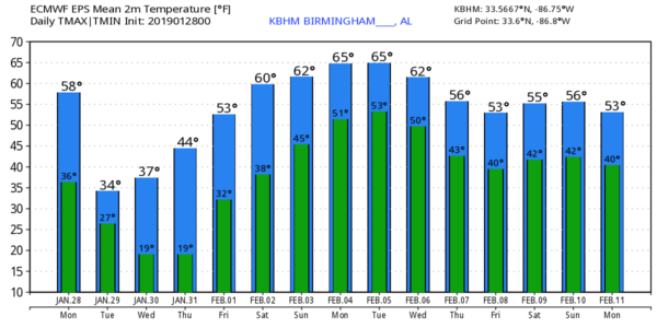
THURSDAY/FRIDAY: Thursday will be a sunny day with a high in the low 50s. Then, on Friday, clouds increase with a chance of showers by afternoon; the high will be in the mid to upper 50s.
THE ALABAMA WEEKEND: Temperatures rise into the 60s Saturday and Sunday. The sky will be generally cloudy, and a few showers are possible both days. But, probably nothing too heavy or widespread.
NEXT WEEK: We will have some risk of rain for at least the first half of the week with a slow moving front just to the north; highs will be in the 60s Monday and Tuesday. See the Weather Xtreme video for maps, graphics, and more details.
ON THIS DATE FIVE YEARS AGO: “Snowmageddon” crippled much of North/Central Alabama for several days. It was only about 2 inches of snow, but temperatures were in the 17-22 degree range as the snow fell. After initially melting, we had a “flash freeze”, putting down a base of ice on all roads, making travel almost impossible. Thousands had to abandon their cars and walk home, or to any warm place they could find. Children were stranded at school, and many were stuck at work.
BEACH FORECAST: Click here to see the AlabamaWx Beach Forecast Center page.
WEATHER BRAINS: Don’t forget you can listen to our weekly 90 minute show anytime on your favorite podcast app. This is the show all about weather featuring many familiar voices, including our meteorologists here at ABC 33/40.
CONNECT: You can find me on all of the major social networks…
Facebook
Twitter
Instagram
Pinterest
Snapchat: spannwx
We will keep the blog updated with fresh information tonight and tomorrow… stay tuned…
Category: Alabama's Weather, ALL POSTS, Weather Xtreme Videos, Winter Weather
About the Author (Author Profile)
James Spann is one of the most recognized and trusted television meteorologists in the industry. He holds the AMS CCM designation and television seals from the AMS and NWA. He is a past winner of the Broadcast Meteorologist of the Year from both professional organizations.Subscribe
If you enjoyed this article, subscribe to receive more just like it.


