Turning Sharply Colder Friday
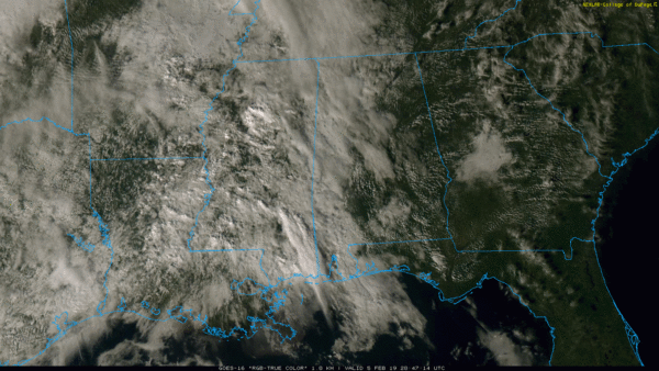
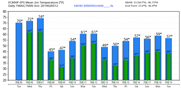
FEBRUARY WARMTH CONTINUES THROUGH MID-WEEK: Temperatures are generally in the low 70s across Alabama this afternoon; the sky is mostly cloudy over the western counties at mid-afternoon, with a partly sunny sky to the east. There is very little on radar.
Tonight will be mostly cloudy with a few isolated showers possible; temperatures won’t drop below the low 60s.
TOMORROW/THURSDAY: Not much change tomorrow; more clouds than sun, a few scattered showers, and a high in the low 70s for most communities. Then, Thursday looks mostly dry during the day with a mix of sun and clouds. For now we are forecasting a high of 75 degrees, within one degree of the record high for February 7, 76 set in 1999. Showers will likely move through the state Thursday night ahead of a cold front.
COLDER FRIDAY: Friday will be a different kind of day with a much colder airmass dropping into the state. Breezy, cold, and lingering clouds most of the day. Temperatures will hold in the 40s over the northern counties with a cool north breeze. Some partial clearing is possible Friday afternoon.
Friday night will be cold; we project a low in the mid 20s by early Saturday morning as the sky becomes clear and the wind dies down.
THE ALABAMA WEEKEND: Saturday will be a sunny day with a high near 50, and we have removed the chance of showers Sunday. The day will be partly sunny with a high between 56 and 60 degrees.
NEXT WEEK: Most of the week looks mostly cloudy and mild with some risk of showers on a daily basis; highs mostly in the 60s. On a positive note, we see no risk of severe storms, tornadoes, flooding, snow, or ice across Alabama for the next 7 to 10 days. See the Weather Xtreme video for maps, graphics, and more details.
ON THIS DATE IN 2008: The 2008 Super Tuesday tornado outbreak was underway; it was a deadly event which affected the Southern United States and the lower Ohio Valley on February 5 and 6, 2008. The event began on Super Tuesday, when 24 United States states were holding primary elections and caucuses to select the presidential candidates for the upcoming presidential election. Missouri, Illinois, Arkansas, Alabama, and Tennessee were among the affected regions in which primaries were being held. Some voting locations were forced to close early due to the approaching severe weather. A total of 57 people were killed across four states and 18 counties, with hundreds of others injured.
After midnight that night, a supercell that developed over Starkville, Mississippi, and tracked over Lamar, Marion and Fayette Counties in Alabama. It spawned a tornado in Lawrence County at 3:02 am CT. The tornado touched down south of Moulton… many houses were damaged or destroyed, and a church was leveled. Three fatalities, all from a single family, were reported north of Aldridge Grove. Another tornado was responsible for a death in Jackson County.
BEACH FORECAST: Click here to see the AlabamaWx Beach Forecast Center page.
WEATHER BRAINS: Don’t forget you can listen to our weekly 90 minute show anytime on your favorite podcast app. This is the show all about weather featuring many familiar voices, including our meteorologists here at ABC 33/40.
CONNECT: You can find me on all of the major social networks…
Facebook
Twitter
Instagram
Pinterest
Snapchat: spannwx
Look for the next Weather Xtreme video here by 7:00 a.m. tomorrow…
Category: Alabama's Weather, ALL POSTS, Weather Xtreme Videos
About the Author (Author Profile)
James Spann is one of the most recognized and trusted television meteorologists in the industry. He holds the AMS CCM designation and television seals from the AMS and NWA. He is a past winner of the Broadcast Meteorologist of the Year from both professional organizations.Subscribe
If you enjoyed this article, subscribe to receive more just like it.


