Record Warmth Tomorrow; Much Colder Friday
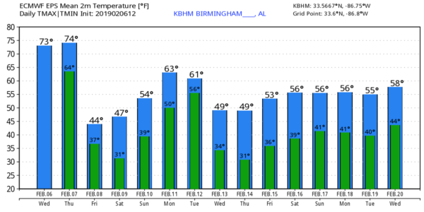
ANOTHER SPRING-LIKE AFTERNOON: Birmingham is enjoying a temperature of 74 degrees at 3:00p CT… within two degrees of the record high today, 76 set in 1999. The sky features more clouds than sun, and we have a few showers on radar, mainly over the Tennessee Valley of far North Alabama.
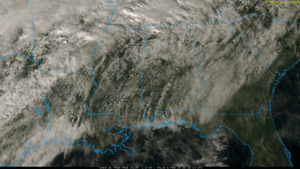
Tonight will be mostly cloudy with a few scattered showers over the northern quarter of the state. Severe storms are possible in a broad zone from far North Texas to western parts of Kentucky and Tennessee.
RECORD WARMTH POSSIBLE TOMORROW: Tomorrow will be warm and mostly dry across Alabama with a mix of sun and clouds; the high will be in the 76 to 80 degree range. A good chance we will establish a new record daily maximum temperature at Birmingham; the record high for tomorrow (February 7) is also 76 set in 1999. Then, tomorrow night, a cold front will pass through with a weakening band of showers. No risk of severe storms in our state despite the warmth.
MUCH COLDER FRIDAY: We will forecast gradual clearing Friday, and the day will be much colder. Temperatures will hold in the 40s over the northern half of the state, and a brisk northwest wind will make it feel colder. A freeze is likely Friday night with a clear sky and diminishing wind; we project temperatures down in the mid 20s by daybreak Saturday.
THE ALABAMA WEEKEND: Saturday will be a sunny and cool day with a high in the low 50s. Sunday looks dry as well with a partly sunny sky; Sunday’s high will in the 57-60 degree range. Clouds will thicken Sunday night.
NEXT WEEK: Monday and Tuesday will be mostly cloudy and mild with a chance of showers both days… highs will be in the 60s. A cold front will pass thorough early Wednesday; some rain is likely Wednesday, especially during the morning hours, and the weather turns colder with temperatures falling into the 40s. Thursday and Friday look cool and dry… see the Weather Xtreme video for maps, graphics, and more details.
ON THIS DATE IN 1978: A massive nor’easter buried the cities of the northeastern U.S. Storm totals included 18 inches in New York City, 16 inches at Philadelphia, and 14 inches at Baltimore. The Boston MA area received 25 to 30 inches in “The Great New England Blizzard,” and the mayor outlawed travel in the city for an entire week.
BEACH FORECAST: Click here to see the AlabamaWx Beach Forecast Center page.
WEATHER BRAINS: Don’t forget you can listen to our weekly 90 minute show anytime on your favorite podcast app. This is the show all about weather featuring many familiar voices, including our meteorologists here at ABC 33/40.
CONNECT: You can find me on all of the major social networks…
Facebook
Twitter
Instagram
Pinterest
Snapchat: spannwx
I enjoyed seeing the students at First Assembly Christian School in Ashland yesterday, and Mitchell Elementary in Gadsden this morning… be looking for them on the Pepsi KIDCAM today at 5:00 and 6:00 on ABC 33/40 News! The next Weather Xtreme video will be posted here by 7:00 a.m. tomorrow…
Category: Alabama's Weather, ALL POSTS, Weather Xtreme Videos
About the Author (Author Profile)
James Spann is one of the most recognized and trusted television meteorologists in the industry. He holds the AMS CCM designation and television seals from the AMS and NWA. He is a past winner of the Broadcast Meteorologist of the Year from both professional organizations.Subscribe
If you enjoyed this article, subscribe to receive more just like it.


