

Weather Xtreme Video for Sunday Morning: Heavy Rain, Flooding, and Storms For Alabama This Week
It was mainly quiet across Alabama this morning. Temperatures have warmed overnight and are in the 50s area-wide now. a few light showers are showing up on radar across the northern third of the area. Those showers will continue to increase and become widespread as we go through the day for areas along and north of I-20. They will end from the northwest tonight ahead of a weak cold front. Most folks will see 0.25-0.50 inches of rain, but some areas like Jasper, Cullman, and Fort Payne could see over an inch by tomorrow morning.
Skies will be mostly cloudy north of a line from Demopolis to Clanton to Roanoke, but south of that line, sunshine will push readings to near or above 70F. The I-20 Corridor will see highs in the middle and upper 60s. North Central Alabama locations like Cullman and Jasper will stay in the lower 60s. Northeast Alabama won’t get out of the 50s.
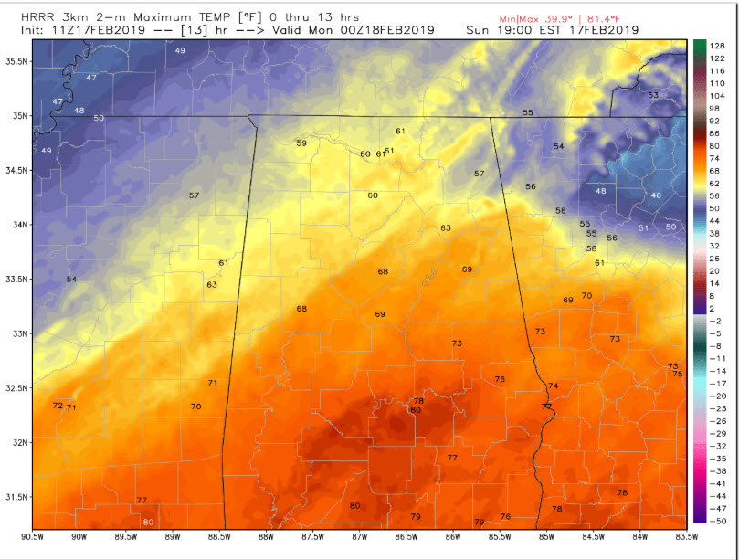
Highs for your Sunday
FOR YOUR MONDAY
Monday will be cooler with some sunshine as high-pressure noses it. Highs will be in the 50s along and north of I-20 with 60s to the south. Rain will begin returning late Monday evening, and there could be a few pellets of sleet on the front end of the precipitation in places like Hamilton and Cullman. Lows will be in the upper 30s around US-278 from Hamilton to Gadsden, with readings near 40F for Tuscaloosa, Birmingham, and Anniston. 40s will prevail further south.
YUCKY TUESDAY
Tuesday will be cloudy, dreary, cold and rainy for most of the day and night. Highs will be in the 40s along and north of I-20 with lower 50s to the south. There could be a little thunder over western sections but don’t count on it.
HEAVY RAIN WEDNESDAY
A cold front will try to force the issue on Wednesday, bringing more rain. Many spots will get over two inches of rain, and on top of the inch from Tuesday and half an inch from today, flooding may start to become a problem. Thunderstorms may be involved with a little instability over the area.
THURSDAY
The front lurks across the area continuing to provide a focus for rain and storms. A few storms could be strong to severe south of I-20. It will be warmer for areas south of the front, with upper 60s and lower 70s. Areas northwest of I-59 will be in the 59s however.
FRIDAY
Looks a lot like Thursday, with more rain and storms and a threat for severe weather for portions of the area. Highs will be in the 60s and 70s.
SATURDAY
Rain and storms will increase ahead of a cold front that will finally put an end to the rain. Highs areawide will be in the 70s.
VOODOO
Looks like more heavy rain and storms on March 1st and 2nd as the month appears that it will roar in like a lion.
WEATHERBRAINS
We will be talking Australian weather on Monday night with the President of the American Meteorological Society, who is a Penn State professor working in the Land Down Under right now.
TODAY IN WEATHER HISTORY
On this date in 2003, six major airports in the Northeast were closed as the major Presidents Day snowstorm was pounding the region. Baltimore recorded its biggest snowstorm on record with 26.5 inches.
Category: Alabama's Weather, ALL POSTS
About the Author (Author Profile)
Bill Murray is the President of The Weather Factory. He is the site's official weather historian and a weekend forecaster. He also anchors the site's severe weather coverage. Bill Murray is the proud holder of National Weather Association Digital Seal #0001 @wxhistorianSubscribe
If you enjoyed this article, subscribe to receive more just like it.


