Mild Through Friday; A Few Showers
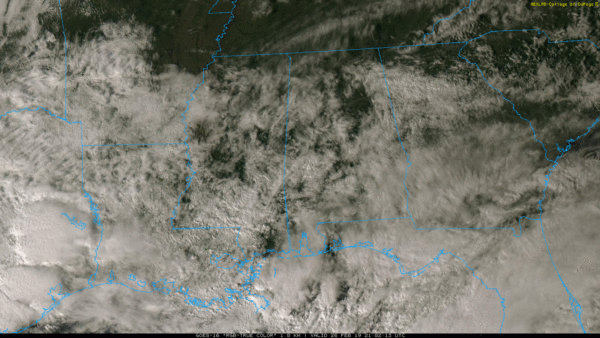
PLEASANT AFTERNOON: With a partly sunny sky, temperatures are mostly in the 67-70 degree range across North/Central Alabama this afternoon. We note a few scattered showers over the southern half of the state. Clouds will increase statewide tonight.
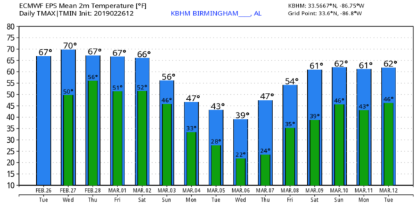
TOMORROW THROUGH FRIDAY: The weather won’t change too much tomorrow; we expect a mix of sun and clouds with only isolated showers… the high will be between 68 and 72 as the mild weather continues. The best chance of rain comes late tomorrow night into Thursday morning, when amounts of 1/4 to 1/2 inch are possible. Then, the chance of showers will be relatively small Thursday afternoon through Friday. The latest guidance suggests most of the day Friday will be dry with a high in the low 70s.
THE ALABAMA WEEKEND: Models are beginning to converge on a weekend forecast solution, but there is still uncertainty. Saturday will be mostly cloudy, and a few showers are possible, but the most widespread rain will most likely come on Sunday as an Arctic front pushes through Alabama. Saturday will stay comfortable with a high in the 60s, but much colder air begins to enter the state Sunday. Much of North Alabama will most likely fall into the 40s as the rain falls Sunday.
NEXT WEEK: Rain will end early Monday as cold air continues to deepen across the state. For now the threat of any wintry precipitation looks fairly low, but we will keep a close eye on model trends. Otherwise Monday will be cloudy and cold with temperatures not getting out of the 40s; some places over the Tennessee Valley could hold in the 30s. Mid-week looks cold and dry with highs mostly in the 40s and lows in the 20s…see the Weather Xtreme video for maps, graphics, and more details.
TORNADO SURVEYS: NWS Birmingham identified three tornadoes in Alabama from Saturday’s thunderstorms… an EF-1 near Kingville in Lamar County (between Vernon and Kennedy), another EF-1 in Coosa County southeast of Rockford, and an EF-0 near the Fayette/Walker County line. Thankfully there were no injuries. The tornado at Columbus, MS was rated EF-3 by the NWS Jackson. One person was killed there, and 11 injuries were reported.
ON THIS DATE IN 2011: The tallest tree in Wales falls after a wind storm. Located on the Lake Vyrnwy Estate, this 124-year-old Douglas fir stood at 63.7 m (208.9 feet). The tree reportedly was leaning over and had two substantial cracks in the main trunk. This tree would be carved into a giant hand.
BEACH FORECAST: Click here to see the AlabamaWx Beach Forecast Center page.
WEATHER BRAINS: Don’t forget you can listen to our weekly 90 minute show anytime on your favorite podcast app. This is the show all about weather featuring many familiar voices, including our meteorologists here at ABC 33/40.
CONNECT: You can find me on all of the major social networks…
Facebook
Twitter
Instagram
Pinterest
Snapchat: spannwx
I enjoyed seeing a home school group this morning at the Church at Ross Bridge in Hoover… be looking for them on the Pepsi KIDCAM today at 5:00 on ABC 33/40 News! The next Weather Xtreme video will be posted here by 7:00 a.m. tomorrow…
Category: Alabama's Weather, ALL POSTS, Weather Xtreme Videos
About the Author (Author Profile)
James Spann is one of the most recognized and trusted television meteorologists in the industry. He holds the AMS CCM designation and television seals from the AMS and NWA. He is a past winner of the Broadcast Meteorologist of the Year from both professional organizations.Subscribe
If you enjoyed this article, subscribe to receive more just like it.


