Showers Late Tonight/Tomorrow; Much Colder Next Week
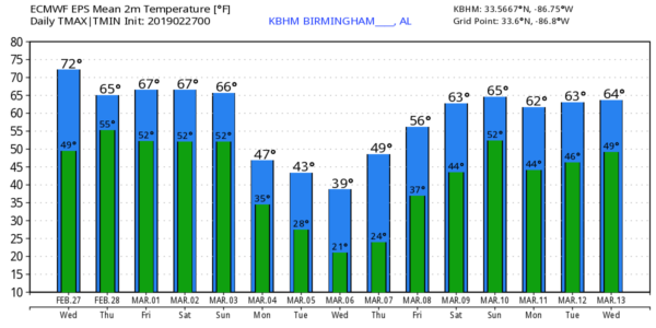
MILD THROUGH FRIDAY: Today will be pretty mild for the end of February; we project a high in the 70-75 degree range this afternoon. The sky will feature more clouds than sun, but the day will be generally dry with only isolated showers. Showers will arrive late tonight, after midnight, and tomorrow will be a cloudy day with occasional showers and possibly a thunderstorm. The most widespread rain tomorrow should come during the morning hours, and the high will be in the 60s.
Then, on Friday, showers should be fairly widely scattered with a mostly cloudy sky… we project a high Friday afternoon between 66 and 70 degrees.
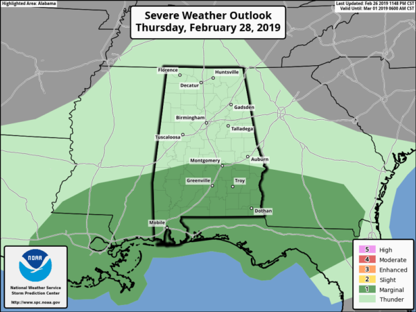
No severe storms are forecast for the northern half of Alabama through Friday, but SPC has defined a “marginal risk” (level 1/5) of severe thunderstorms for the southern quarter of the state tomorrow and Friday as instability values will rise there.
THE ALABAMA WEEKEND: Overall forecast confidence in the weekend forecast remains fairly low with a complex pattern across the Deep South. Saturday will be mostly cloudy and mild with a chance of showers; the high will be in the low 70s. But I would not consider the day a “wash-out”.
The most widespread rain will come on Sunday as an Arctic front approaches. There is great difference in global model output; the American global model (the GFS) shows a cold rain with falling temperatures, but the European model (the ECMWF) shows a much warmer environment with unstable air along with a chance of strong, maybe even severe thunderstorms. Again we will side the the Euro and trend the forecast toward a warmer and more stormy day.
Rain amounts over the weekend will be in the 1 to 2 inch range for most of Alabama.
NEXT WEEK: Very cold, Arctic air will move into the state. Highs will be only in the 40s Monday through Wednesday, with lows well down in the 20s each morning. Colder pockets across North Alabama could reach the upper teens Tuesday and Wednesday morning. Temperatures moderate late in the week, and a few showers are possible by Friday. See the Weather Xtreme video for maps, graphics, and more details.
FYI: The average date of the last freeze in Birmingham is March 25, but keep in mind we have experienced a freeze as late as April 23.
ON THIS DATE IN 1999: Severe thunderstorms moved across Alabama producing damaging winds and a few tornadoes. An EF-2 tornado touched down near Locust Fork in Blount County, another EF-2 produced damage at Killen in Lauderdale County. An EF-0 tornado brought down trees near Southside in Etowah County.
BEACH FORECAST: Click here to see the AlabamaWx Beach Forecast Center page.
WEATHER BRAINS: Don’t forget you can listen to our weekly 90 minute show anytime on your favorite podcast app. This is the show all about weather featuring many familiar voices, including our meteorologists here at ABC 33/40.
CONNECT: You can find me on all of the major social networks…
Facebook
Twitter
Instagram
Pinterest
Snapchat: spannwx
I have a weather program this morning at Bessemer Academy… look for the next Weather Xtreme video here by 4:00 this afternoon. Enjoy the day!
Category: Alabama's Weather, ALL POSTS, Weather Xtreme Videos
About the Author (Author Profile)
James Spann is one of the most recognized and trusted television meteorologists in the industry. He holds the AMS CCM designation and television seals from the AMS and NWA. He is a past winner of the Broadcast Meteorologist of the Year from both professional organizations.Subscribe
If you enjoyed this article, subscribe to receive more just like it.


