Dry Through Tomorrow; Strong Storms Thursday
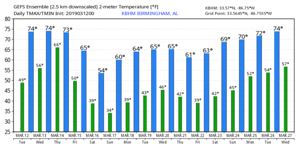
NICE WARM-UP TODAY: We are starting the day with temperatures mostly in the 40s early this morning; we project a high in the low 70s this afternoon with a good supply of sunshine. Tomorrow will be dry as well… with a mix of sun and clouds we expect a high in the mid 70s.
STRONG/SEVERE STORMS THURSDAY: A very intense surface low will form tomorrow across the Great Plains; models suggest the core pressure could drop to 972 mb (28.70″) over western Kansas by afternoon. This will bring very high wind and blizzard conditions to parts of Colorado, Wyoming, and Nebraska, and the risk of strong to severe storms southeast of the surface low in the warm sector.
The low will move up into Iowa Thursday, and the trailing cold front will push into Alabama Thursday evening. Ahead of the front, a band of rain and storms will push into Alabama, and SPC has introduced a risk of severe thunderstorms for a decent part of the state.
We have the standard “slight risk” (level 2/5) for areas west of a line from Huntsville to Birmingham to Linden, and a “marginal risk” (level 1/5) as far east as Gadsden, Rockford, Monroeville, and Satsuma.
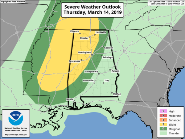
The main limiting factor is instability. There is a chance we have a rain mass move through Thursday morning, which would keep the air stable and mitigate the chance of severe storms later in the day. But, if we don’t get much rain during the morning, and if the sun can break out at times, instability values could be higher and accordingly the chance of severe storms would rise as well.
The 12 hour window for severe thunderstorms Thursday will come from noon to midnight, but the core threat is during the afternoon and evening hours. Storms will be capable of producing strong gusty winds and some hail, and an isolated tornado can’t be totally ruled out.
Rain amounts should be around one inch Thursday, and we are not expecting any flooding issues.
FRIDAY AND THE WEEKEND: Rain will end early Friday, and the sky becomes partly sunny by afternoon as drier air returns. Friday will be cooler with a high in the 60s. Then, the weekend looks dry with cool days and chilly nights. We will drop into the 32-36 degree range both Saturday and Sunday morning with potential for frost, and a freeze for colder pockets across North/Central Alabama. The high Saturday will be in the upper 50s, followed by low 60s Sunday… the sky will be mostly sunny both days.
NEXT WEEK: For now the week looks generally dry with seasonal temperatures. See the Weather Xtreme video for maps, graphics, and more details.
ON THIS DATE IN 1993: The generational “Blizzard of 93” was underway. All 67 Alabama counties had measurable snow; winds gusted to nearly hurricane force on ridges with white out conditions, snow amounts of 1 to 2 feet were common over the northern half of the state, with drifts to 4 feet. There was a lot of eerie green lightning followed by the muffled sound of thunder during the peak of the storm. With the atmosphere overloaded with big snowflakes, part of the sound of thunder was absorbed. Some had no power for over a week. We forecast 6 to 16 inches of snow going into the event, but many didn’t listen since it was mid-March, the flowers were blooming, and the high on March 10, 1993 (two days before the blizzard) was 75.
To the south, between Louisiana and Cuba, hurricane-force winds associated with the system produced high storm surges across the Big Bend of Florida which, in combination with scattered tornadoes, killed dozens of people.
WEATHER RADIO PROGRAMMING IN JACKSONVILLE: We will be in Jacksonville next Monday night, March 18, programing weather radios. Bring your weather radio and we will check it for you; we will be on the 5th floor of JSU Stadium from 4:00 until 6:30 p.m. I will be there doing weather live on ABC 33/40.
BEACH FORECAST: Click here to see the AlabamaWx Beach Forecast Center page.
WEATHER BRAINS: Don’t forget you can listen to our weekly 90 minute show anytime on your favorite podcast app. This is the show all about weather featuring many familiar voices, including our meteorologists here at ABC 33/40.
CONNECT: You can find me on all of the major social networks…
Facebook
Twitter
Instagram
Pinterest
Snapchat: spannwx
I have weather programs this morning at Pinson Elementary, and in Hayden for a home school group.. look for the next Weather Xtreme video here by 4:00 this afternoon. Enjoy the day!
Category: Alabama's Weather
About the Author (Author Profile)
James Spann is one of the most recognized and trusted television meteorologists in the industry. He holds the AMS CCM designation and television seals from the AMS and NWA. He is a past winner of the Broadcast Meteorologist of the Year from both professional organizations.Subscribe
If you enjoyed this article, subscribe to receive more just like it.


