Some Clouds & Gusty Winds At Midday; Severe Storm Threat Tomorrow
AT 12:45 PM
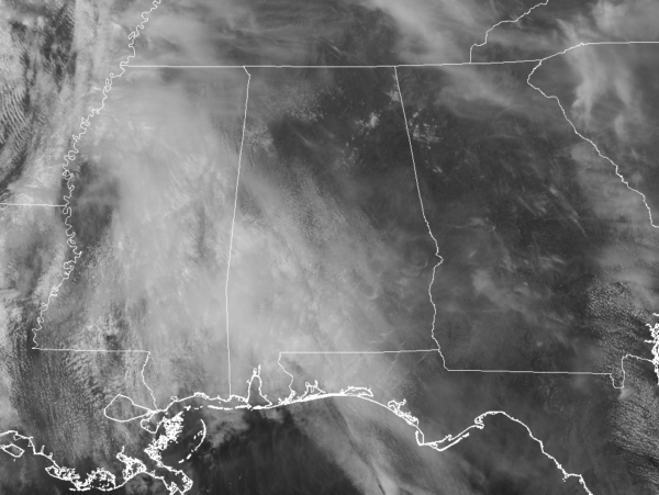
Much of the area has some cloud cover overhead at this point, but there is a good bit of sun shining over the northeastern parts of the area. But hold on to your hat and whatever else you are carrying if you go outside. Pressure gradient winds are gusting at times up to 30 MPH… Strong enough to affect larger vehicles on the roadways and rearranging your unsecured lawn furniture. Temperatures are already in the mild category, currently in the upper 60s to the lower 70s. The coolest spot on the board at this point is Alexander City at 69 degrees, while several locations have tied as the warm spot at 73 degrees. Birmingham was just one degree below that at 72 degrees.
WEATHER FOR THE REST OF YOUR WEDNESDAY
If you don’t mind the gusty winds and some cloud cover, the rest of the afternoon will not be all that bad across Central Alabama. Skies will remain partly to mostly cloudy across the area with afternoon highs topping out in the 70s. Winds will be quite breezy, averaging 10-15 MPH out of the south-southeast with gusts up to 30 MPH, thanks to the tightening of the pressure gradient from the approaching system that will affect us tomorrow. For tonight, we’ll stay dry through the evening and late night hours before rain chances begin to rise after midnight. We’ll have the chance of scattered showers over the northwestern half of the area during the overnight hours with lows dropping into the 60s across Central Alabama.
SEVERE STORM THREAT ON THURSDAY
We continue to have the potential for strong to severe storms across mainly the western half of Central Alabama with the main threats of damaging winds and isolated tornadoes. A strong cold front will be moving through the area between the hours of 1:00 pm Thursday and midnight.
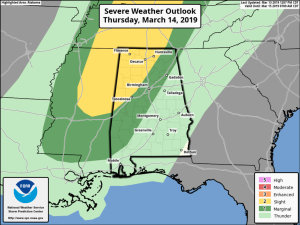
SPC has a Slight Risk (level 2 of 5) defined for locations in Central Alabama west of a line from Emelle (Sumter Co.) to Tuscaloosa to Fairview (Cullman Co). A Marginal Risk (level 1 of 5) extends eastward from the slight risk to a line from Selma (Dallas Co.) to Thorsby (Chilton Co). to Gadsden (Etowah Co.).
There is still some uncertainty to this system as the amount of morning rainfall could hamper the instability for the afternoon hours. If there is not a lot of rain and we get some sun at times, that will allow instability values to climb making the atmosphere more ripe for severe thunderstorms. If there is more rainfall with cloud cover, that will keep the atmosphere cooler and more stable which will help prevent storm development.
At this point, the main window for stronger to severe storms will be from 1:00 pm to midnight from northwest to southeast in the severe risk defined areas. After midnight, we’ll lose the better dynamics as the responsible for the storms will have moved well off into Canada north of the Great Lakes.
Highs will be in the lower 70s to the lower 80s across the area from northwest to southeast, with lows in the mid-40s to the lower 60s.
BEACH FORECAST CENTER
Get the latest weather and rip current forecasts for the beaches from Fort Morgan to Panama City on our Beach Forecast Center page. There, you can select the forecast of the region that you are interested in.
CONNECT WITH THE BLOG ON SOCIAL MEDIA
You can find the AlabamaWx Weather Blog on these major social media networks:
Facebook
Twitter
Follow on both, especially in situations like today where one is down, you can still get information from us on the other.
Category: Alabama's Weather, ALL POSTS
About the Author (Author Profile)
Scott Martin is an operational meteorologist, professional graphic artist, musician, husband, and father. Not only is Scott a member of the National Weather Association, but he is also the Central Alabama Chapter of the NWA president. Scott is also the co-founder of Racecast Weather, which provides forecasts for many racing series across the USA. He also supplies forecasts for the BassMaster Elite Series events including the BassMaster Classic.Subscribe
If you enjoyed this article, subscribe to receive more just like it.


